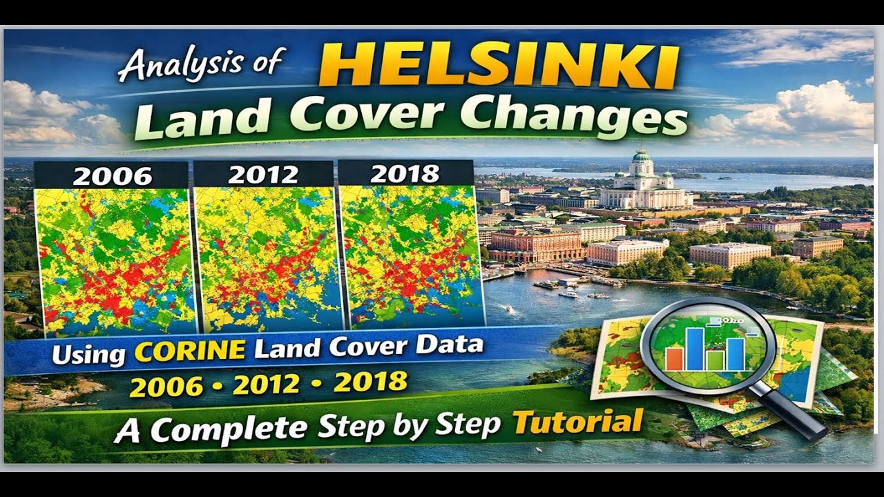
Analysis of Helsinki Land Cover Changes Using CORINE Land Cover Data for 2006, 2012 and 2018
Автор: Geojay GIS Solution
Загружено: 2026-01-19
Просмотров: 24
Описание:
#LandCoverAnalysis #CORINEData #HelsinkiGIS #finland #RemoteSensing #EnvironmentalChange
In this detailed tutorial, we will analyze land cover changes in Helsinki using CORINE Land Cover data from 2006, 2012, and 2018. This step-by-step guide is perfect for beginners and experienced GIS analysts alike, providing insights into land use dynamics over the years. This video aims to enhance your remote sensing and GIS skills, making it a valuable resource for researchers, planners, and anyone interested in environmental change. Don’t forget to like, subscribe, and hit the notification bell for more tutorials!
Buy me a coffee here: https://buymeacoffee.com/geojay
For business and enquiries: WhatsApp+2347065365193 or Email: [email protected]
Facebook Group: / 1fn4oqzn1l
Related videos:
How to download and style CORINE Land Cover in QGIS | Coordination of Information on the Environment: • How to download and style CORINE Land Cove...
How to Clip CORINE Land Cover and Style the Legend in QGIS: • How to Clip CORINE Land Cover and Style th...
How to create EU Account to Access CORINE Land Cover Data | Land use of the European Continent: • How to create EU Account to Access CORINE ...
SPECIAL GIS MODULES FOR YOU:
Groundwater Potential Analysis in GIS A Complete Module: https://buymeacoffee.com/geojay/e/498877
Geo-Referencing, Digitization and Data Attribution in GIS: https://buymeacoffee.com/geojay/e/478159
How To Produce Geological Map Shapefile or Generate Geology Shapefile of any Area: https://buymeacoffee.com/geojay/e/478816
Normalized Difference Vegetation Index (NDVI) Calculation and Reclassification: https://buymeacoffee.com/geojay/e/481012
Helsinki land cover, CORINE data, land cover changes, GIS tutorial, remote sensing, environmental analysis, spatial analysis, geographic information systems, land use planning, data processing, land cover mapping, change detection, 2006 2012 2018, urbanization, environmental monitoring, land classification, GIS analysis, satellite imagery, data visualization, land use change, city planning, ecological studies, geographic data, tutorial guide, time series analysis, data integration, environmental science, urban planning, remote sensing techniques, geographic analysis, map creation, land cover types, data interpretation, CORINE land cover, environmental management, data trends, mapping techniques, field data collection, hydrography, vegetation mapping, urban studies, land fragmentation, spatial datasets, aquifer mapping, natural resource management, statistical analysis, software tutorial, environmental indicators, data accuracy, scientific research, mapping revisions, classification systems, policy planning, municipal analysis, urban ecology, land degradation, socio-economic impacts, urban growth, natural systems, climate change, geospatial technology, image processing, spatial resolution, project management, administrative mapping, urban sprawl, landscape ecology, ecological design, user experience, sustainable practices, mapping software, environmental justice, flood risk assessment, monitoring systems, land ownership analysis, community engagement, sustainability studies, open-source GIS, geodatabase, modeling techniques, stakeholder engagement, educational resources, remote sensing applications, project evaluation, metadata management, qualitative analysis, quantitative analysis, system integration, community resources, thematic mapping, urban heat islands, land capability, spatial relationships, habitat loss, cartography principles, risk assessment, environmental conservation, data guidelines, vegetation indices, topographic mapping, site assessments, geological mapping, longitudinal studies, public health implications, climatic factors, agricultural mapping, educational content, hydrology, coastal studies, regulatory frameworks, surface analysis, participatory mapping, public outreach, capacity building, project deliverables, mapping standards, historical analysis, biodiversity mapping, habitat assessments, site analysis, qualitative data, land cover datasets, visualization techniques, urban forestry, ecosystem services, temporal analysis, spatial data management, planning regulations, interdisciplinary research, habitat modeling, land restoration, pollution tracking, socio-environmental studies, landscape metrics, data sources, partnerships in mapping, integration of data, urban features, community-based mapping, interactive mapping, cellular data, resource allocation, digital mapping, scientific exploration, water resource studies, academic research, outcome assessments, integrated studies, graph analysis, impact assessments, visual storytelling, land monitoring.
Повторяем попытку...
Доступные форматы для скачивания:
Скачать видео
-
Информация по загрузке: