ycliper

Популярное

Музыка Кино и Анимация Автомобили Животные Спорт Путешествия Игры Юмор

Интересные видео

2025 Сериалы Трейлеры Новости Как сделать Видеоуроки Diy своими руками

Топ запросов

смотреть а4 schoolboy runaway турецкий сериал смотреть мультфильмы эдисон
Скачать

ITRF & ICRF Explained: How Earth’s Motion Shapes Global Positioning Accuracy

Автор: Offshore Surveys

Загружено: 2022-06-15

Просмотров: 4248

Описание: Ever wondered how we measure Earth’s rotation, crust movement, and satellite positions with millimeter precision? 🌍 In this video, we explore the science behind the International Terrestrial Reference Frame (ITRF) and International Celestial Reference Frame (ICRF) — the backbone of modern geodesy, GNSS accuracy, and space navigation.

🛰️ What you'll learn:
Why WGS 84 isn’t enough for high-precision geodesy
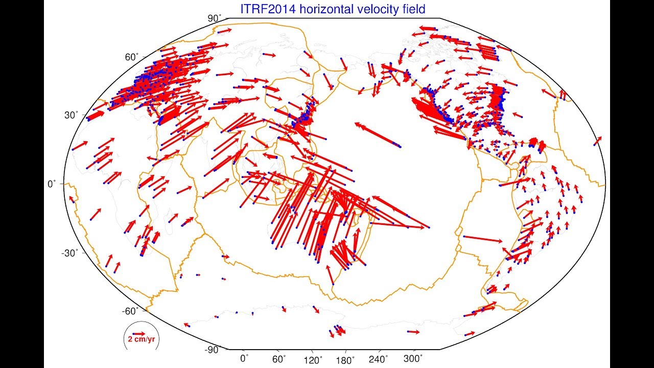
How tectonic plate movement affects GNSS reference stations
What Earth Orientation Parameters (EOP) are and why they matter
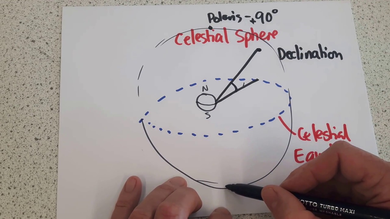
How celestial bodies like quasars and pulsars anchor our reference frames
The role of GNSS, VLBI, SLR, and DORIS in defining ITRF
How satellite laser ranging (SLR) helps measure Earth’s geocenter
Differences between ITRF and WGS 84 — and why 1mm matters
Why ITRF 2020 is the future, but many still use ITRF 2014

📡 Whether you're a surveyor, geophysicist, GNSS engineer, or just curious about how we track Earth’s motion, this video gives you a complete overview of the systems that keep our positioning accurate — from satellites to space telescopes.

🎓 This video is part of the "GNSS & Geodesy Fundamentals" series on Offshore Surveys — your trusted resource for mastering satellite navigation, reference frames, and Earth science.

#ITRF2020 #ICRFExplained #GeodesyFundamentals #GNSSAccuracy #EarthRotation #SatelliteLaserRanging #VLBI #DORIS #WGS84vsITRF #OffshoreSurveys

If you are interested to know more about the subject please check out the References below. If you like the content, Please give me a Big Thumbs Up and perhaps Subscribe to my channel.

Reference :
https://www.fig.net/resources/publica...
https://www.iers.org/IERS/EN/Home/hom...
https://itrf.ign.fr/en/homepage
https://itrf.ign.fr/ftp/pub/itrf/itrf...
https://www.iag-aig.org/
https://confluence.qps.nl/qinsy/lates...
https://ggos.org/item/terrestrial-ref...
https://earth-info.nga.mil/
http://www.iausofa.org/2020_0721_C/so...

Не удается загрузить Youtube-плеер. Проверьте блокировку Youtube в вашей сети.
Повторяем попытку...
ITRF & ICRF Explained: How Earth’s Motion Shapes Global Positioning Accuracy

Поделиться в:

Доступные форматы для скачивания:

Скачать видео

  • Информация по загрузке:

Скачать аудио

Похожие видео

Is Your GNSS System ITRF2020 Compliant? How do you Check?

Is Your GNSS System ITRF2020 Compliant? How do you Check?

Что такое ITRF? Координатная основа Земли

Что такое ITRF? Координатная основа Земли

Global reference systems - ITRS, ICRS and GCRS

Global reference systems - ITRS, ICRS and GCRS

3.3 - From Keplerian parameters to Earth centered Earth fied ECEF frame

3.3 - From Keplerian parameters to Earth centered Earth fied ECEF frame

(EN) Terrestrial Reference Frames - Connecting the World through Geodesy

(EN) Terrestrial Reference Frames - Connecting the World through Geodesy

The GENIUS of Inertial Navigation Systems Explained

The GENIUS of Inertial Navigation Systems Explained

The Only Video Needed to Understand Orbital Mechanics

The Only Video Needed to Understand Orbital Mechanics

Special Topics - GPS (64 of 100) ECEF: Earth Centered Earth Fixed Coordinate System

Special Topics - GPS (64 of 100) ECEF: Earth Centered Earth Fixed Coordinate System

Galactic Sphere, Declination, Right Ascension

Galactic Sphere, Declination, Right Ascension

The Earth and the Geographic Coordinates

The Earth and the Geographic Coordinates

Азимут магнитный. Дирекционный угол. Как их определить на карте. Гринвичский меридиан.

Азимут магнитный. Дирекционный угол. Как их определить на карте. Гринвичский меридиан.

Что такое ортометрическая высота?

Что такое ортометрическая высота?

What are Geodetic Datums?

What are Geodetic Datums?

How does Starlink Satellite Internet Work?📡☄🖥

How does Starlink Satellite Internet Work?📡☄🖥

Системы координат в геодезии. Зональная система прямоугольных координат. Гаусса-Крюгера

Системы координат в геодезии. Зональная система прямоугольных координат. Гаусса-Крюгера

Best Practices for Minimizing Errors during GNSS Data Collection

Best Practices for Minimizing Errors during GNSS Data Collection

Механизмы, которые должен знать КАЖДЫЙ инженер-механик

Механизмы, которые должен знать КАЖДЫЙ инженер-механик

Почему магниты магнитят?

Почему магниты магнитят?

DORIS the space surveyor (EN)

DORIS the space surveyor (EN)

GGOS: Terrestrial Reference Frames - Connecting the World through Geodesy

GGOS: Terrestrial Reference Frames - Connecting the World through Geodesy

© 2025 ycliper. Все права защищены.


  • Контакты
  • О нас
  • Политика конфиденциальности


Контакты для правообладателей: [email protected]