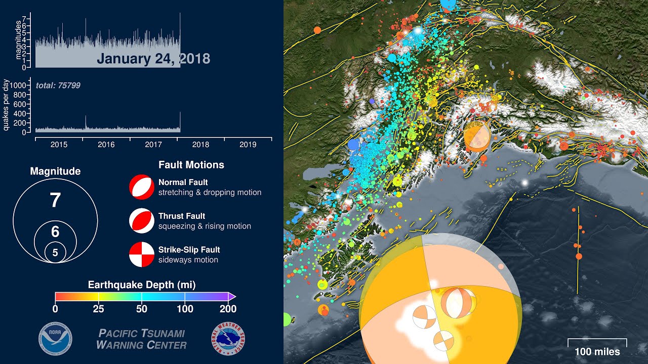
Five Years of Earthquakes in Southern Alaska: 2015 - 2019
Автор: PacificTWC
Загружено: 2020-01-25
Просмотров: 6046
Описание:
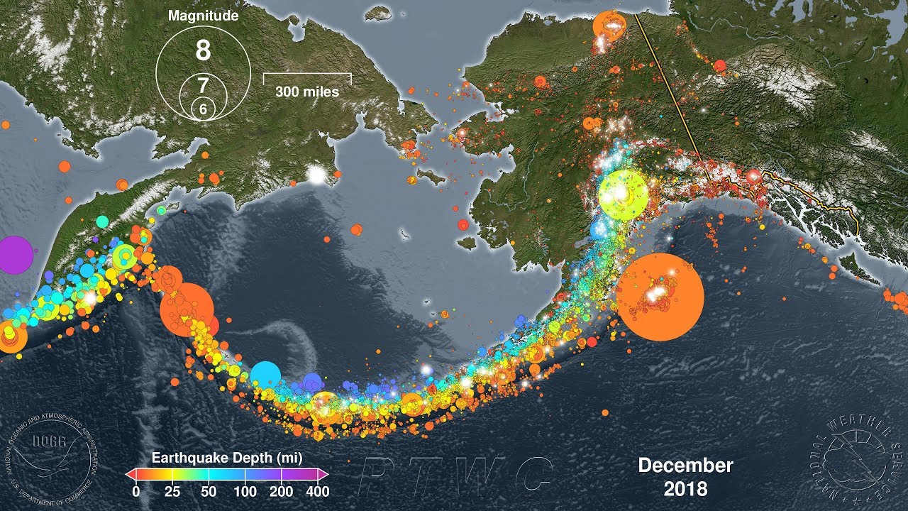
Alaska lies above a tectonic plate boundary called a “subduction zone” such that the Pacific Plate grinds beneath the North American Plate. This type of plate boundary can create volcanoes, such as Redoubt, Augustine, and Katmai. Subduction zones can also produce megathrust earthquakes with large vertical motions that cause devastating tsunamis, such as the M9.2 Great Alaska Earthquake that struck Prince William Sound in 1964. A subduction zone boundary will also produce many smaller earthquakes, and they can be seen in this animation as the earthquakes that become deeper and deeper the further away they occur from the plate boundary, the Aleutian Trench. Meanwhile, both plates also host their own shallow earthquakes that result from many smaller faults that form as they are being squeezed and sheared by their collision in this subduction zone. In other words, there is one gigantic fault--the subduction zone megathrust--and many smaller faults on both the Pacific and North American Plates that can produce earthquakes.
For an earthquake to pose a tsunami hazard it has to be able to significantly move the sea floor in a vertical direction, either by suddenly dropping or popping up. Therefore, when an earthquake occurs the scientists in the tsunami warning centers need to rapidly determine an earthquake’s location, including its depth. Is it on land or under the ocean? Is it shallow enough to move the seafloor, or is it so deep that it doesn’t pose a risk? They then determine its magnitude, since a larger earthquake will move more of the sea floor and over a larger area. These parameters can be determined within a matter of minutes. But over the course of the first hour following an earthquake they will continue to analyze their data and they may also be able to determine which direction the seafloor moved. It may have moved primarily in a vertical direction (either up or down), and thus pose a greater tsunami risk. Or it may have moved mostly sideways, posing a lesser tsunami hazard. Once these scientists have this information they can use it to better predict how dangerous a tsunami may be, but until they can figure it out they will assume the worst-case scenario of maximum vertical motion. If they figure out later that the earthquake is something else, such as an earthquake that mostly moved sideways, they may downgrade or cancel their tsunami alert. A graphical way to show this sense of motion for earthquakes is the “focal mechanism” sometimes informally referred to as a “beach ball.” These symbols are included in this animation to show which direction some of the earthquakes moved, especially the larger ones. Note that the locations of the focal mechanisms do not exactly coincide with the circles representing the hypocenters. That is because earthquake rupture starts in one spot then moves across the surface of a fault plane. The hypocenter circles represent where this rupture starts, whereas the focal mechanisms are positioned such that they represent the location of the average of all of the motion from the earthquake. Imagine you’re unzipping your jacket: the hypocenter is where the slider was at the top of your jacket, while the centroid will be somewhere around the middle of the zipper.
Thankfully the largest earthquakes that occurred in the five year period covered by this animation did not pose a significant tsunami hazard because they were too far inland, too deep, not big enough, or moved sideways. Three particularly large earthquakes occurred during this five-year period:
Jan 24, 2016 -- M 7.1 -- east of Old Iliamna, Alaska -- deep with sideways and downward motion
Jan 23, 2018 -- M 7.9 -- southeast of Kodiak -- shallow but with sideways motion (small tsunami)
Nov 30, 2018 -- M 7.1 -- Anchorage -- deep and inland with downward motion but damaging
The U.S. Pacific Tsunami Warning Center (PTWC) and the U.S. National Tsunami Warning Center (NTWC) will issue tsunami alerts for any potentially tsunami-causing earthquake in the Alaska region. These alerts will be posted to:
https://tsunami.gov
For a more thorough explanation of focal mechanisms, please watch:
• Focal Mechanisms Explained: What are those...
To see how subduction zones make tsunamis, please watch:
• How to Make a Tsunami
-----
Earthquake Data Source: United States Geological Survey (USGS)/National Earthquake Information Center (NEIC) searchable catalog:
https://earthquake.usgs.gov/earthquak...
Focal Mechanisms Source: Global Centroid Moment Tensor Project (GCMT):
https://www.globalcmt.org/
Plate Boundary from UTIG’s PLATES Project:
https://ig.utexas.edu/marine-and-tect...
Fault Lines from the State of Alaska’s Division of Geologic and Geophysical Surveys (DGGS):
https://dggs.alaska.gov/
Повторяем попытку...
Доступные форматы для скачивания:
Скачать видео
-
Информация по загрузке: