Philippines Pushes Back Against China’s 9-Dash Line with New International Law–Aligned Map
Автор: Geo Analysis Hub
Загружено: 2026-01-29
Просмотров: 856
Описание:
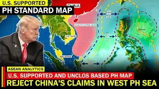
Manila is making waves in the South China Sea once again. The Philippine government has released a newly updated maritime map that directly counters China’s expansive 9-dash line claim—one of the most disputed issues in Asian geopolitics. Unlike China’s vague historical assertions, the Philippines’ map is firmly grounded in international law under UNCLOS.
In this episode, we explain how this map reinforces the Philippines’ sovereign rights over its Exclusive Economic Zone and why it represents more than just a symbolic gesture. By clearly defining maritime boundaries, Manila is not only asserting its legal position but also strengthening its case in diplomatic engagements and international forums.
This move comes amid rising tensions in the West Philippine Sea, where encounters between Philippine vessels and Chinese coast guard ships have increased. The new map provides clarity for allies, investors, and regional partners who rely on stable and lawful maritime boundaries.
We also explore how this development fits into the broader geopolitical landscape, including U.S.–Philippine defense cooperation, freedom of navigation operations, and growing international resistance to China’s maritime claims. Could this map influence future arbitration efforts or regional cooperation within ASEAN?
Stay tuned as we unpack the legal, political, and strategic consequences of Manila’s latest move—and what it signals for the future of the South China Sea.
Disclaimer:
This video has been created by AI using human efforts for research, scripting, and editorial review.
References:
– UNCLOS official framework
– 2016 South China Sea Arbitration ruling
– Philippine Department of Foreign Affairs statements
– Regional security and maritime law reports
Повторяем попытку...

Доступные форматы для скачивания:
Скачать видео
-
Информация по загрузке: