Leica GS18 GPS in Action – Surveying Faster Than Ever! 🚀📡
Автор: The Global Surveyor
Загружено: 2025-03-27
Просмотров: 886
Описание:
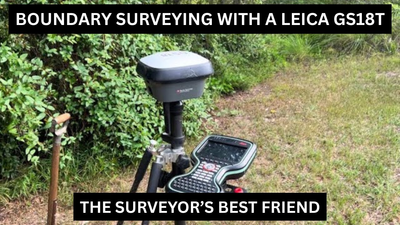
In this short exercise, we explore boundary surveying in a rural forest location using the Leica GS18 and Leica Captivate. Watch as we locate survey marks (GIPs) and undertake a basic localization by creating a coordinate system with the Leica Captivate software. This practical demo will show how to efficiently find survey marks in challenging environments and establish accurate coordinates for mapping.
Key topics covered:
Locating GIPs (survey marks) using the Leica GS18
Performing a basic localization with the Leica Captivate "Create Coordinate System" feature
Surveying in a rural forest environment
Setting up and using the Leica GS18 in real-world conditions
Tips for accurate coordinate system creation using Leica Captivate
This video is perfect for surveyors looking to sharpen their skills and improve their fieldwork with Leica equipment. Don't forget to like, subscribe, and hit the notification bell for more surveying tutorials and tech tips!
#LeicaGS18 #SurveyMarks #GIP #LeicaCaptivate #SurveyingInForest #CoordinateSystem #SurveyingTutorial #LandSurveying #LeicaSurveying #FieldSurveying
#SurveyMarks #GPS #LeicaTS16 #TotalStation #SurveyingLife #ProfessionalSurveyor #SurveyingTechniques #LandSurveyingAustralia #SurveyingCommunity #Geospatial #CivilEngineering #ConstructionSurveying #TopoSurvey #BoundarySurvey #SurveyControl #SurveyReferenceMark #DrillHole #SurveyTripod #LeicaSNLL321 #LaserPlummet #CircularPrisms #LeicaGeosystems #TheGlobalSurveyor #SurveyingEquipment #GeodeticSurveying #EngineeringSurvey #PropertySurvey #LandSurveyorTools #SurveyingTechnology #GNSS #RTK #DroneSurveying #Mapping #TopoMapping #LandDevelopment #SurveyingFieldwork #SurveyCrew #PrecisionSurveying #SurveyingWorkflow #CadastralSurveying #RealEstateSurveying #BoundaryMarking #SurveyControlPoints #TotalStationSetup #3DSurveying #Geomatics #LiDAR #GISMapping #SurveyingTools #SurveyingSoftware #ProfessionalLandSurveyor #LandSurveyingTechnology #SiteSurveying #ConstructionStaking #SurveyingWithGPS #SurveyFieldwork #RemoteSensing #MappingAndSurveying #SurveyData #ControlSurvey #LandMeasurement #TopographicMapping #CivilSurveying #BoundaryMark #ConstructionSiteSurveying #InfrastructureSurveying #FieldSurveying #SurveyMarkers #SurveyReference #CoordinateSurvey #GroundControlPoints #SurveyingIndustry #SurveyingAndMapping #SurveyorCommunity #SurveyorWork #TotalStationSurveying #GPSLandSurveying #LandSurveyingWork #SurveyingTraining #SurveyingEducation #SurveyingTips #SurveyingBusiness #SurveyingCareers #SurveyingExperts #SurveyingInnovation #SurveyingWorld #GeospatialSurveying #3DMapping #AerialSurveying #SurveyingAdventures #BoundarySurveying #SurveyingInstruments #SurveyingProjects #SurveyingMethods #SurveyingSkills #LandSurveyingWorkflows #SurveyingVideos #SurveyingTutorial #SurveyingChallenges #SurveyingAccuracy #SurveyingAndGIS #SurveyingToolsAndTechniques #ModernSurveying #HistoricalSurveyMarks #SurveyingResources #SurveyingExperiences #ConstructionSurveyingMethods #SurveyingSolutions #SurveyingIndustryUpdates #SurveyingHistory #AdvancedSurveying #SurveyingMeasurements #LandSurveyingEquipment #SurveyingAndTechnology #SurveyingInnovationAndTech #SurveyingBasics #SurveyingForBeginners #SurveyingWorkshops #SurveyingFieldTechniques #SurveyingSuccess #SurveyingProblems #LandSurveyingReality #SurveyingHacks #SurveyingTechniquesExplained #LandSurveyingCareer #SurveyingInTheField #SurveyingProfessionalTips #LandSurveyingLife #SurveyingAdventureVideos #SurveyingCaseStudies #SurveyingExploration #SurveyingStories #LandSurveyingFacts #SurveyingTutorialsForBeginners #SurveyingSafety #SurveyingAndRemoteSensing #SurveyingWeatherChallenges #SurveyingWithTotalStation #SurveyingWithGNSS #SurveyingDrones #SurveyingWithRTK #SurveyingChallengesAndSolutions #SurveyingCaseStudies
Повторяем попытку...
Доступные форматы для скачивания:
Скачать видео
-
Информация по загрузке:


