29 Mitsuke Tenryu River View
Автор: tokaido53
Загружено: 2025-10-17
Просмотров: 20
Описание:
https://axera.org/to53/
For more information, please click here.
Ukiyoe of the Fifty-three Stages of the Tokaido drawn by Hiroshige Utagawa, I researched the view from where it was seen and actually went there. The route to the places depicted together with explanations of the history and topography of the area are also included in the book.
Click here to view the 100 Famous Places Edo.
Japanese version
https://www.axera.co.jp/edo100/index....
English version
https://www.axera.co.jp/edo100views/i...
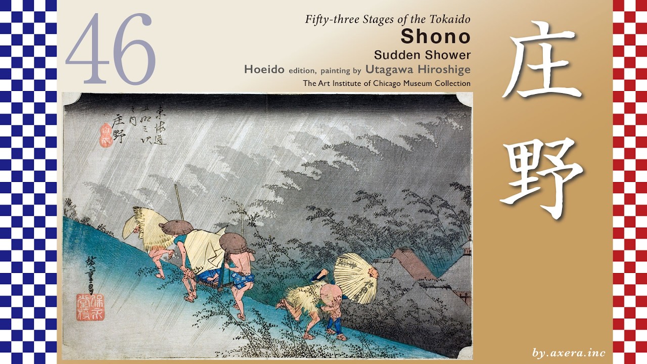
Fifty-three Stages of the Tokaido
Mitsuke
Tenryu River View
Hoeido edition, painting by Utagawa Hiroshige
The British Museum Collection
This depicts the scene of a river crossing by boat on the Tenryu River, which lies between Mitsuke-juku and Hamamatsu-juku.
The distance from Fukuroi-juku to Mitsuke-juku is about 5.9 km, but to reach the Tenryu River depicted by Hiroshige, one had to travel another 7 km further west. First, please see the route between the relay stations.
After passing through Fukuroi-juku on the Tokaido, you will soon come upon the Kihara Ichirizuka, restored to its original size.
Continuing further west, you cross the Ota River and climb the small hill where the ancient battlefield of Dainichido lies.
Continuing further west, beyond the Akiha Mountain night beacon, lies the signpost for Mitsuke-juku. Formally, the area beyond this point constitutes Mitsuke-juku.
After passing the honjin in Mitsuke-juku, the Tokaido turns left just before crossing the river, heading toward what is now Iwata Station and passing by the ruins of the Totomi Kokubunji along the way.
If one continued straight ahead instead of turning at the honjin, they could take the shortest route to the Tenryu River ferry crossing, known as the Ikeda Shortcut or Hime-kaido. However, this path was a narrow mountain trail difficult for palanquins, horses, and luggage to traverse. Therefore, the official main route remained the Tokaido, which descended southward.
Traveling along the Tokaido road near the Tenryu River, there was a Tateba called Nagamori. Here, a famous ointment called “Nagamori Kouyaku” was sold, effective for chapped skin and cuts, and it was very popular.
On the other hand, taking the Hime Kaido road marked by the green line allowed one to pass through the ancient battlefield known as Hitokoto-zaka, significantly shortening the distance to the ferry crossing at Ikeda Village.
At this Hitokoto-zaka slope, in 1572, a battle took place between Takeda Shingen, who invaded from Kai Province, and the 31-year-old Tokugawa Ieyasu, lord of Totomi Province. Thanks to the valiant efforts of Honda Tadakatsu, the Tokugawa forces were able to retreat safely to Hamamatsu. The following year, at the famous Battle of Mikatagahara, the allied forces of Tokugawa and Oda Nobunaga were also soundly defeated by the Takeda army.
Here, please look at this map from the Meiji period by the Geospatial Information Authority of Japan.
In connection with these battles, Tokugawa Ieyasu guaranteed the residents of Ikeda Village, who had consistently supported the Tokugawa forces, the right to operate the ferry across the Tenryu River. Consequently, Ikeda Village held the exclusive right to operate the Tenryu River ferry until the end of the Edo period and obtained the right to collect part of the operating costs from the province of Totomi. For this reason, the Tenryu River ferry was also known by the alternate name “Ikeda Ferry.”
Please note the green line on the map. Before the Edo period, the road serving as an alternative to the Tokaido along the Pacific coast was this Kamakura-Kaido. At that time, the roads leading from various regions to Kamakura, where the Kamakura Shogunate was located, were collectively called the Kamakura Kaido. In this area, it was called the Kyo-Kamakura Okan or the Kamakura-kaido. During the Heian period, ferry services across the Tenryu River became commonplace, and the village of Ikeda on its west bank thrived.
Later, during the Edo period, kaido improvements were made, and the Tokaido was rerouted southward to accommodate carts and the sankin-kotai system, bypassing the old Kamakura-kaido. That's the indigo-colored road. The green-colored old Kamakura-kaido, along with the kaido beyond it, was collectively called the Hime-kaido.
Please refer to the wide-area map here. The green Hime kaido, after crossing the Tenryu River, could proceed straight westward to pass through the northern side of Lake Hamana.
This route was called the Hime-kaido because it bypassed the strict checkpoint at Araino-seki-gate, famous for its "Enter the gun and leave the woman," passing through Kiga and Mikkabi instead, and connecting to Goyu via the Honzaka Pass.
"Enter the gun and leave the woman," refers to the strict regulations imposed by the Edo shogunate to prevent rebellion. These regulations targeted “firearms and other weapons entering Edo” and “daimyo wives and women leaving Edo” at checkpoints.
Повторяем попытку...

Доступные форматы для скачивания:
Скачать видео
-
Информация по загрузке:


![1 A.M Study Session 📚 [lofi hip hop]](https://imager.clipsaver.ru/lTRiuFIWV54/max.jpg)