44 Yokkaichi Miegawa River
Автор: tokaido53
Загружено: 2026-02-15
Просмотров: 6
Описание:
https://axera.org/to53/
For more information, please click here.
Ukiyoe of the Fifty-three Stages of the Tokaido drawn by Hiroshige Utagawa, I researched the view from where it was seen and actually went there. The route to the places depicted together with explanations of the history and topography of the area are also included in the book.
Click here to view the 100 Famous Places Edo.
Japanese version
https://www.axera.co.jp/edo100/index....
English version
https://www.axera.co.jp/edo100views/i...
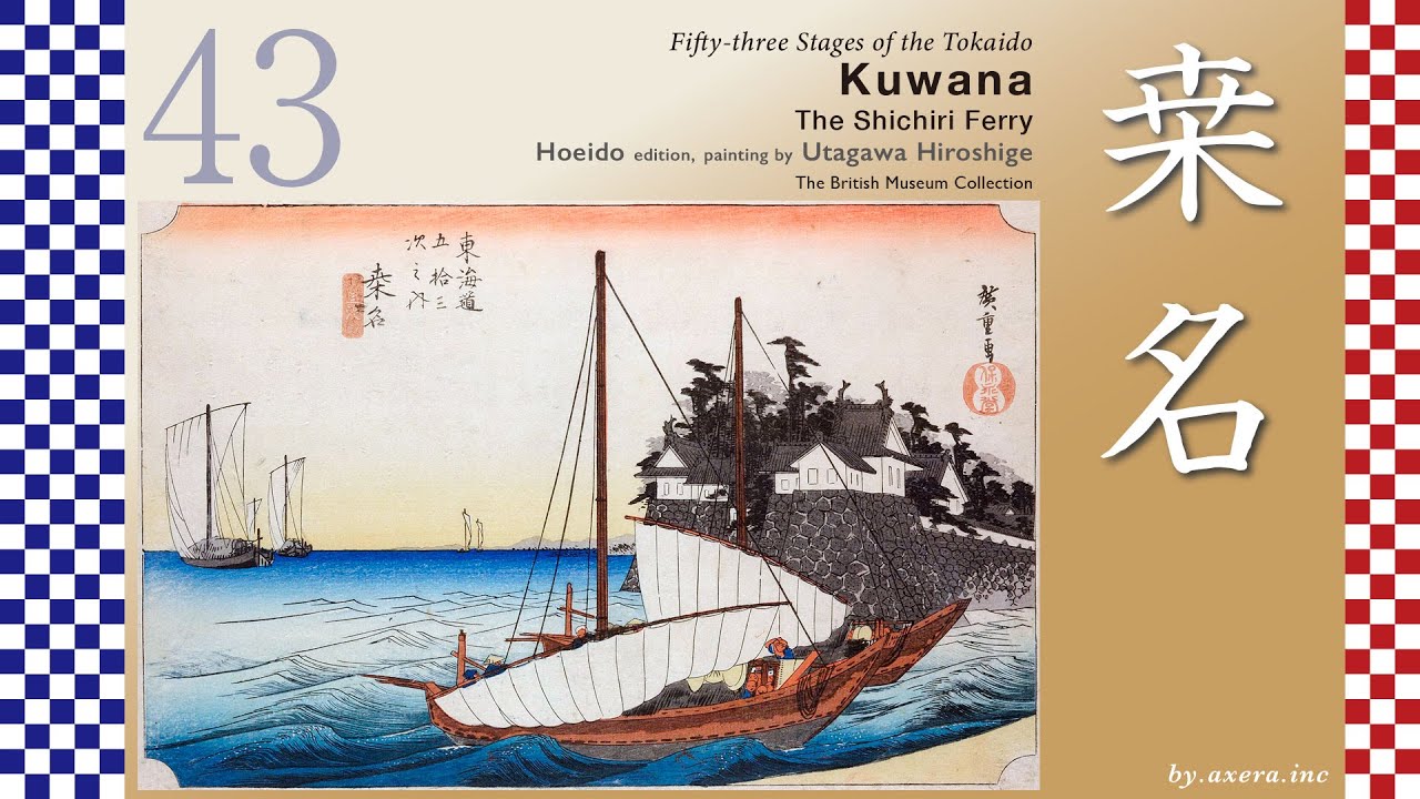
In this scene, we are looking at a view depicting the area around the Mie River―today’s Mitaki River―where the Tokaido crossed just before reaching Yokkaichi.
Travelers, having arrived at Kuwana Juku via the Shichiri Ferry Crossing, set out once again, heading about 13 kilometers south-southwest toward their next destination, Yokkaichi Juku.
After leaving Kuwana, they passed through the zigzagging streets typical of a castle town before gradually turning south. Near Machiya Bridge stood a stone lantern dedicated to the Ise Grand Shrines, quietly watching over the travelers. Today, both the name of the river and the location of the bridge have changed, reminding us of the passage of time.
The Tokaido passes beneath the Kintetsu Line, follows the JR Kansai Main Line southward, and, after passing under the Isewangan Expressway, reaches the Matsudera rest station.
After passing under the JR Kansai Main Line and two Kintetsu lines, travelers arrive at the Tomida Ichirizuka milestone mound. This was a resting place that Hiroshige depicted in his Gyosho edition “Kuwana” print, showing a clam shop.
Continuing southward for a while, travelers cross the Kaizo River―now famous for cherry blossoms―then the Mitaki River, and enter Yokkaichi Juku. Hiroshige’s depiction of Yokkaichi shows this very spot, just before the Mitaki River, which served as the gateway to the Yokkaichi Juku. Today, the Tokaido runs through a lively covered shopping arcade near the station called “Suwamae.”
After passing through Yokkaichi, a large torii gate soon comes into view. This is Hinaga no Oiwake, an important junction where the Tokaido and the Ise Kaido―Pilgrimage Road diverge. Beyond the gate stretched the road leading to Ise Grand Shrine.
Let us now enlarge the area around Yokkaichi, highlighting Hiroshige’s viewpoint with a red gradient.
The “Mie River” mentioned in Hiroshige’s subtitle refers to the Mitaki River. Upstream, in Komono, lies Yunoyama SPA, a hot spring resort long cherished as a therapeutic retreat, which supported the region’s prosperity.
Immediately after crossing the river, Yokkaichi Juku had its Honjin. In the past, the road ran straight all the way to Suwa Shrine. Although it is now divided by a national highway, we can still imagine its former appearance.
Let us look again at the wider map.
At that time, there was also a route that went directly from Miya Juku to Yokkaichi without using the Shichiri or Sanri ferry crossings. This was known as the Juri Ferry Crossing. Established in 1601 with the approval of Tokugawa Ieyasu, it began on a small scale but gained many users from the mid-Edo period onward. Travelers found it more convenient to continue directly to Yokkaichi rather than heading north for about one ri back to Kuwana.
However, as a result, Kuwana Juku, which lost customers, submitted petitions of complaint to the road magistrate. Even in those days, various interests and rivalries were at play.
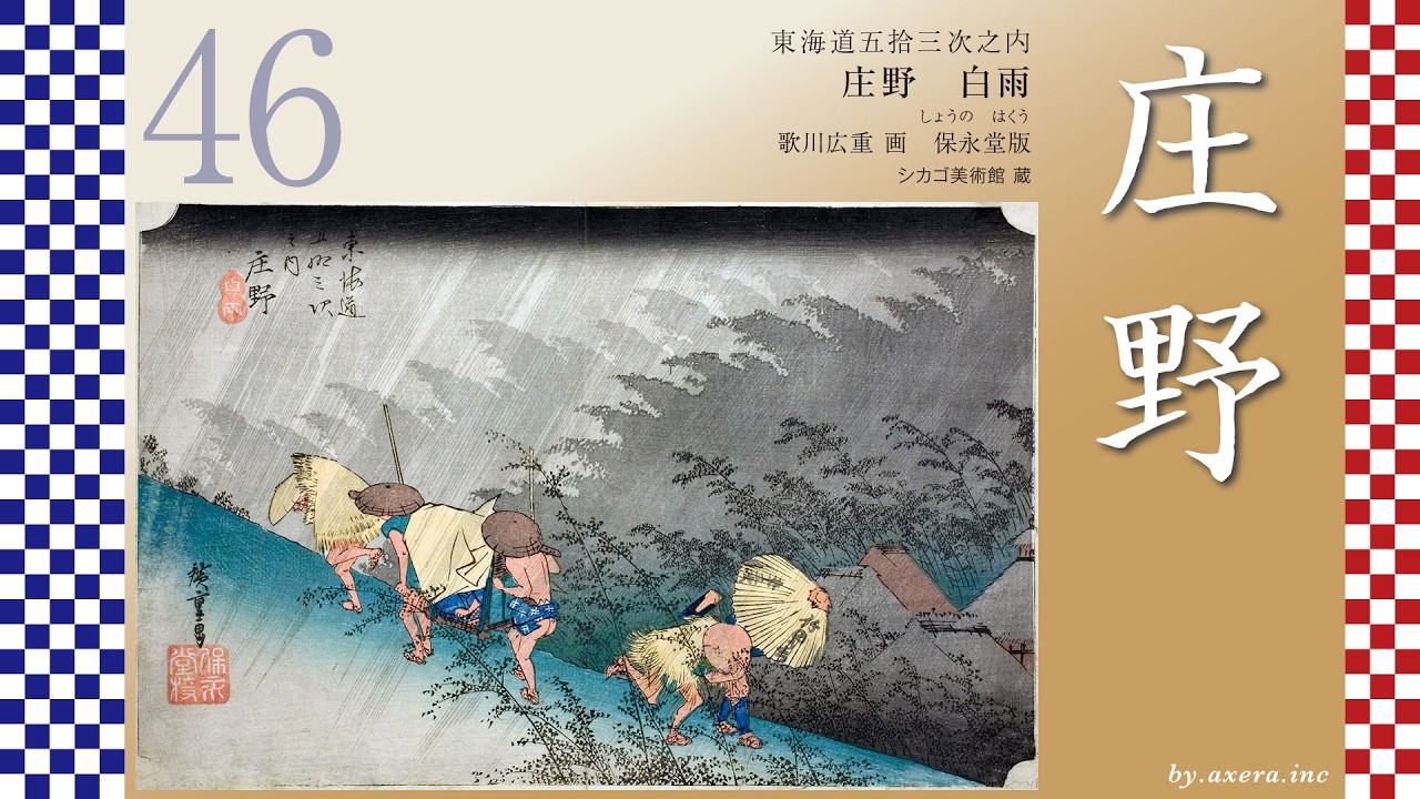
Now, let us turn our attention to Hiroshige’s image.
In the strong wind, one traveler crosses the bridge holding down his raincoat, while another desperately chases after his flying sedge hat. This contrast vividly conveys both the hardship of travel and human warmth. The willow branches, blown by the wind, testify to the stormy weather of that day.
In the distance, we see the roofs of Yokkaichi and the sails of cargo ships anchored in the harbor. This sea was once called Nako-no-ura Bay and was famous for mirages. It was believed that within the mist rising from clams, the gods of Ise and Atsuta traveled, creating visions of palaces and towers.
The bridge was a simple structure combining an earthen bridge and a wooden bridge. Reeds grew thickly along the riverbank, and boats were quietly moored there. It was a landscape where travel and daily life were closely intertwined.
In winter, Yokkaichi is well known for the “Suzuka Oroshi,” strong northwesterly seasonal winds that blow down from the Suzuka Mountains. Facing Ise Bay, the area is also exposed to sea winds. On clear winter days, gusts could be so strong that people could barely stand. Hiroshige seems to have captured this atmosphere with lightness and humor.
Повторяем попытку...

Доступные форматы для скачивания:
Скачать видео
-
Информация по загрузке: