31 Maisaka View of Imagire
Автор: tokaido53
Загружено: 2025-10-23
Просмотров: 11
Описание:
https://axera.org/to53/
For more information, please click here.
Ukiyoe of the Fifty-three Stages of the Tokaido drawn by Hiroshige Utagawa, I researched the view from where it was seen and actually went there. The route to the places depicted together with explanations of the history and topography of the area are also included in the book.
Click here to view the 100 Famous Places Edo.
Japanese version
https://www.axera.co.jp/edo100/index....
English version
https://www.axera.co.jp/edo100views/i...
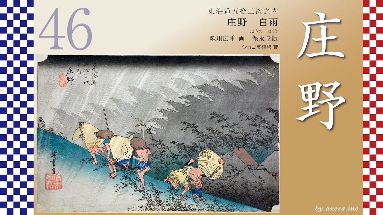
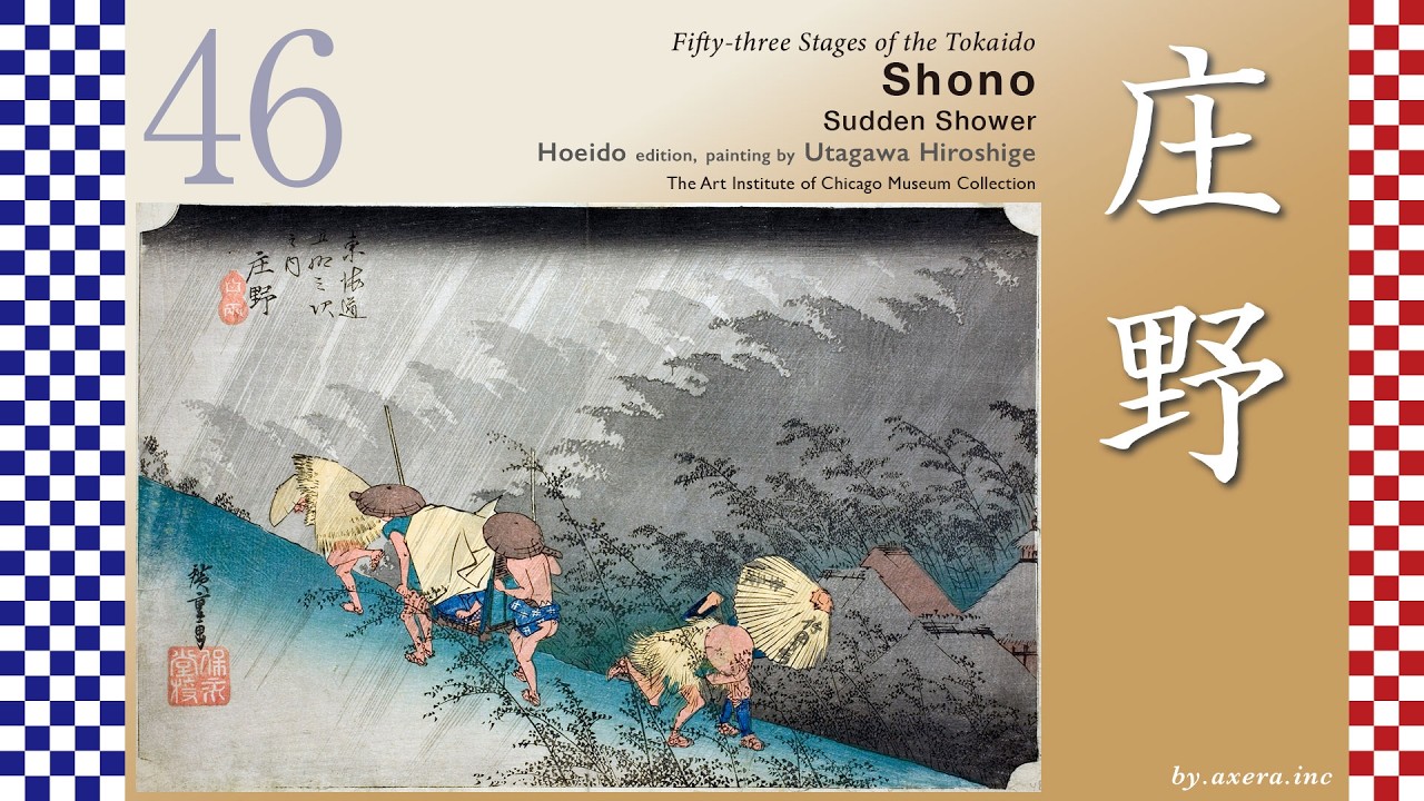
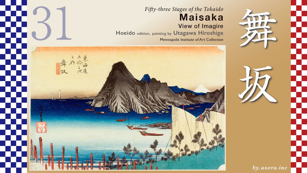
Fifty-three Stages of the Tokaido
Maisaka
View of Imagire
Hoeido edition, painting by Utagawa Hiroshige
Minneapolis Institute of Art Collection
This is a view from the sea of the Imagire Ferry crossing Lake Hamanako, looking toward the Maisaka side.
The route from Hamamatsu-juku to Maisaka-juku is a walk of about 11 kilometers over mostly flat terrain.
The Tokaido road leaves Hamamatsu-juku and runs roughly parallel to the JR railway line as it heads west. Near Takatsuka Station, there were official bulletin board and lanterns at that time.
As you approach Maisaka Station, you can see the dragon lantern of Akiha Shrine on your right. This is a night-time beacon established for pilgrims traveling to Mount Akiha.
From around Maisaka Station, rows of pine trees come into view on both sides. Maisaka-juku began around here, and you can still see many pine trees today.
Please view the wide-area map showing Maisaka-juku, Arai-juku, and Lake Hamanako from here.
After passing through Hamamatsu, the Tokaido route required ferry crossings from Maisaka-juku to Arai-juku. However, by the time Hiroshige depicted this area, it had been struck by several natural disasters.
According to maps from before 1490, Maisaka and Arai were almost connected by land, requiring only crossing a small river flowing out of Lake Hamanako. The entire yellow-green area on this map was also land.
However, the 1498 Meio Earthquake struck the Enshu-nada coast, causing massive land subsidence and triggering a tsunami. The earthquake caused the opening of Lake Hamanako to subside. The resulting tsunami breached the sandbar separating Lake Hamanako from the sea. Consequently, Lake Hamanako, which should have been quite distant from the ocean, became a brackish lake mixed with seawater.
This map depicts the landscape at that time, showing the large, light blue Hamanako Lake.
From here, the Imagire ferry service began operating between Maisaka and Arai. However, disasters continued: in 1510, the sea at Maisaka suffered a major collapse, and in 1699, the Arai barrier across from Maisaka-juku was severely damaged by storm surge.
In 1707, the Hoei Earthquake and Tsunami caused significant damage to Maisaka juku. Across the strait, Arai juku also suffered flooding and collapse affecting 855 houses, and the ferry service sustained major damage. This tsunami damage, combined with improvements to the opening of Lake Hamanako and the relocation of Arai barrire, led to the extension of the Imagire Ferry route connecting Maisaka-juku and Arai-juku. The route was extended to approximately 3.9 km.
Moreover, the Arai barrier was notoriously strict, so much so that it was mockingly called "Enter the gun and leave the woman,". This led to the creation of the Imagire Ferry here, which combined a long, circuitous boat journey with a harshly enforced checkpoint. However, travelers disliked the Tokaido and instead flocked to the Himekaido, which passed north of Lake Hamanako. This is the green line on the map. Furthermore, the pronunciation of “imagire” also implied severing ties, making it deeply unpopular among women. There was even a period when the shogunate itself promoted the Hime Kaido over the disaster-prone Tokaido.
More than a year after the Hoei Earthquake, travelers still avoided the Tokaido Road, and with reconstruction stalled, a sense of crisis grew. In March 1709, petitions were submitted to the shogunate from six relay stations―Maisaka, Hamamatsu, Arai, Shirasuka, Futagawa, and Yoshida―urging that the Tokaido be used for official travel.
It was not until November 1717, eight years later, that the shogunate's Road Commissioner finally issued an order restricting passage on the Himekaido. However, despite this strong directive from the shogunate, ordinary travelers were slow to return to the Tokaido route.
Here, we'll overlay Hiroshige's viewpoint with a red gradient. Using this as a reference, let's examine Hiroshige's paintings in detail.
Повторяем попытку...
Доступные форматы для скачивания:
Скачать видео
-
Информация по загрузке: