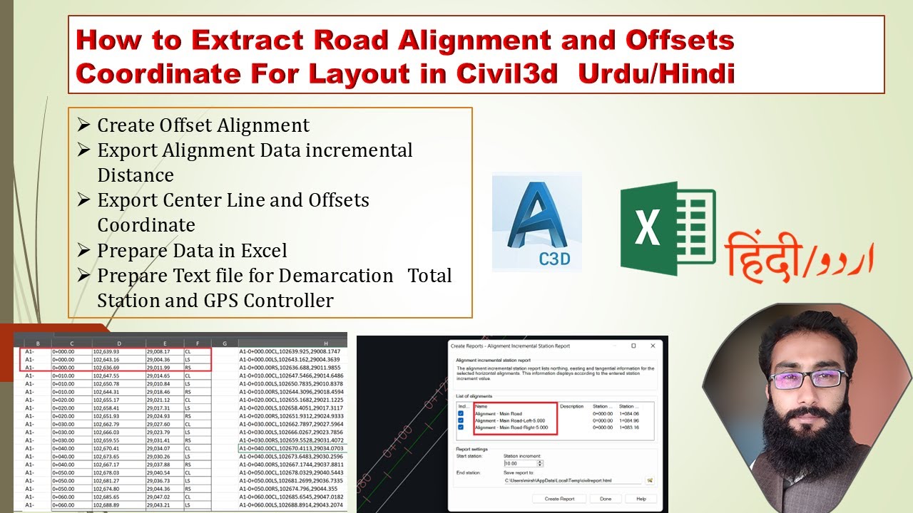
How to Get Road Alignment Station Offset and Coordinate Data in Civil 3d
Автор: Naseer Bhatti
Загружено: 2022-07-20
Просмотров: 4746
Описание:
Excited to share insights on obtaining road alignment station offset and coordinate data in Civil 3D!
In this illuminating video, the process for obtaining road alignment station offset and coordinate data in Civil 3D is meticulously explained. The speaker adeptly presents the creation of the required report, emphasizing the significance of automating elevation settings and generating multiple sets.
The importance of using controller and custom settings for reporting is also elucidated with a detailed walk through. Moreover, the video delves into the manipulation and verification of the generated reports, ensuring the accurate representation of the data. This comprehensive guide sheds light on the intricate process of capturing road alignment station offset and coordinate data, providing invaluable insights for viewers. It's a must-watch for professionals seeking to enhance their proficiency in Civil 3D.
What are your thoughts on this method for obtaining road alignment station offset and coordinate data? Share your insights in the comments & let's explore further together!
Title: Obtaining Road Alignment Station Offset and Coordinate Data in Civil 3D
Creating required report for road alignment station offset and coordinate data
• The speaker has already created the report and is familiar with the process
• The speaker is ready to work on the project and suggests starting
Automate elevation setting and generate additional sets
• Explaining the need for multiple sets of elevation data
• Confirming successful creation and functionality
Using controller and custom settings for reporting
• Entering the plus sign for custom settings
• Generating multiple reports
Deleting duplicate points, 446.16 is next step
• Check for matching point numbers before deleting duplicates
• After deletion, proceed with 446.16
Understanding how road alignment station offset and coordinate data are taken in Civil 3D
• The data is taken in as a continuous sequence of points from the starting point to the end point
• The report generated includes data that continues till the end of the alignment
Get road alignment station offset and coordinate data
• Select the station
• Do the offset
Adjust road alignment station offset and coordinate data
• Set the values on the right side to zero - 3.6, 7.3, and -7.3
• Use control app to write values for each station at different station changes
Getting road alignment station offset and coordinates data in Civil 3D.
• To get the data, check both right and left sides of the center line.
• Copy the data and add a border to it for further use.
https://drive.google.com/file/d/1CTFB...
Timecodes
0:09 creating required report for road alignment station offset and coordinate data
0:58 Automate elevation setting and generate additional sets
4:22 using controller and custom settings for reporting
7:00 Deleting duplicate points, 446.16 is next step
8:01 Understanding how road alignment station offset and coordinate data are taken in Civil 3D
8:30 Get road alignment station offset and coordinate data
10:03 Adjust road alignment station offset and coordinate data
11:24 getting road alignment station offset and coordinate data in Civil 3D.
Повторяем попытку...

Доступные форматы для скачивания:
Скачать видео
-
Информация по загрузке:


![Divine Music - The Year Mix Vol.10 [Chill & Ethnic Deep 2025]](https://imager.clipsaver.ru/Q3XBH_FhuKY/max.jpg)