ycliper

Популярное

Музыка Кино и Анимация Автомобили Животные Спорт Путешествия Игры Юмор

Интересные видео

2025 Сериалы Трейлеры Новости Как сделать Видеоуроки Diy своими руками

Топ запросов

смотреть а4 schoolboy runaway турецкий сериал смотреть мультфильмы эдисон
Скачать

Getting Started with NASA Worldview (December 2021)

Автор: NASA Earthdata

Загружено: 2022-02-09

Просмотров: 12870

Описание: 
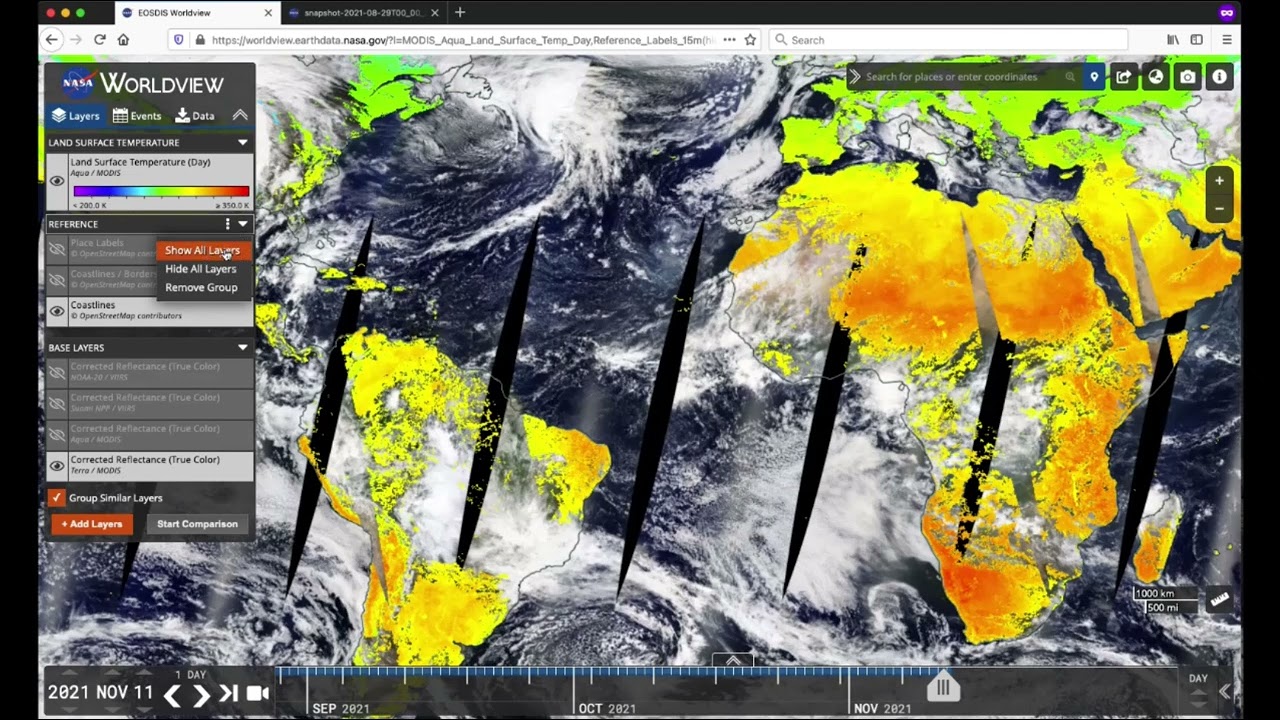
In this tutorial, learn how to use NASA's Earth Observing System Data and Information System (EOSDIS) Worldview imagery mapping and visualization application. Using NASA Worldview, you can explore Earth as it is “right now” and see hurricanes forming, wildfires spreading, icebergs drifting and city lights illuminating. Learn how to interactively explore and visualize over 1,000 NASA Earth science satellite imagery layers, many of which are available within hours, even minutes, and spanning back 20 years.

Worldview has been used for time-critical applications such as wildfire monitoring and management, supporting science through easy-to-access satellite imagery archives, illustrating disasters and natural events in the media, and for education and outreach. We will show you how to create and export an image snapshot, animate imagery to see change over time, compare imagery from different dates, or different types of imagery from the same date, explore vector data layers like Fires and Thermal Anomalies, and much more!

Check out NASA Worldview for yourself at: https://worldview.earthdata.nasa.gov

Не удается загрузить Youtube-плеер. Проверьте блокировку Youtube в вашей сети.
Повторяем попытку...
Getting Started with NASA Worldview (December 2021)

Поделиться в:

Доступные форматы для скачивания:

Скачать видео

  • Информация по загрузке:

Скачать аудио

Похожие видео

Accelerate your Science with On-Demand InSAR Processing from NASA ASF DAAC

Accelerate your Science with On-Demand InSAR Processing from NASA ASF DAAC

OSINT At Home #9 – 4 лучших бесплатных источника спутниковых снимков

OSINT At Home #9 – 4 лучших бесплатных источника спутниковых снимков

Know your Landsat: Understanding and Accessing Landsat Data

Know your Landsat: Understanding and Accessing Landsat Data

An Introduction to Earth Observation - Session 1 - A tour of the technology

An Introduction to Earth Observation - Session 1 - A tour of the technology

EARTH FROM SPACE: Like You've Never Seen Before

EARTH FROM SPACE: Like You've Never Seen Before

Лекция академика РАН А. А. Гиппиуса «Берестяные грамоты из раскопок 2025 г.»

Лекция академика РАН А. А. Гиппиуса «Берестяные грамоты из раскопок 2025 г.»

Expand Your View of Earth with NASA Worldview

Expand Your View of Earth with NASA Worldview

Лучший документальный фильм про создание ИИ

Лучший документальный фильм про создание ИИ

Earthdata Webinar: Explore the Entire Earth, Every Day, with Satellite Imagery from NASA Worldview

Earthdata Webinar: Explore the Entire Earth, Every Day, with Satellite Imagery from NASA Worldview

CEP - Atak na skład amunicji w Rosji. Najnowsze dane z Banku Centralnego Federacji Rosyjskiej

CEP - Atak na skład amunicji w Rosji. Najnowsze dane z Banku Centralnego Federacji Rosyjskiej

SAR Data in Python- Get to Know the ASF Search Module

SAR Data in Python- Get to Know the ASF Search Module

What Satellites Can See From Space Is Troubling

What Satellites Can See From Space Is Troubling

Компоненты и принцип работы мобильных сетей

Компоненты и принцип работы мобильных сетей

NASA ARSET: Satellites, Sensors, and Earth Systems Models for Water Resources Management

NASA ARSET: Satellites, Sensors, and Earth Systems Models for Water Resources Management

Spatial Data Mining I: Essentials of Cluster Analysis

Spatial Data Mining I: Essentials of Cluster Analysis

Discover and Access Earth Science Data Using Earthdata Search

Discover and Access Earth Science Data Using Earthdata Search

NASA ARSET: Satellites, Sensors, Data and Tools for Land Management and Wildfire Applications

NASA ARSET: Satellites, Sensors, Data and Tools for Land Management and Wildfire Applications

🛑 Как БЕСПЛАТНО загрузить спутниковые снимки MAXAR высокого разрешения (0,3 м) с OpenAerialMap

🛑 Как БЕСПЛАТНО загрузить спутниковые снимки MAXAR высокого разрешения (0,3 м) с OpenAerialMap

Google Earth Engine 101: An Introduction for Complete Beginners

Google Earth Engine 101: An Introduction for Complete Beginners

Тропики и полярные круги

Тропики и полярные круги

© 2025 ycliper. Все права защищены.


  • Контакты
  • О нас
  • Политика конфиденциальности


Контакты для правообладателей: [email protected]