ycliper

Популярное

Музыка Кино и Анимация Автомобили Животные Спорт Путешествия Игры Юмор

Интересные видео

2025 Сериалы Трейлеры Новости Как сделать Видеоуроки Diy своими руками

Топ запросов

смотреть а4 schoolboy runaway турецкий сериал смотреть мультфильмы эдисон
Скачать

Mapping Wetlands using Multitemporal Landsat and MNDWI in Earth Engine

Автор: Ramadhan

Загружено: 2023-10-22

Просмотров: 4157

Описание: How to map wetlands in a region quickly? In this video, I will show you a script to do exactly that.

Script: https://code.earthengine.google.com/c...

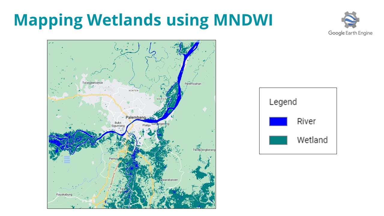
I am using three years of Landsat 8 collection from 2020 to 2022. On each image, I will generate MNDWI (Modified Normalized Difference Water Index). Then I will do a median composite to get the permanent or river. I will also generate the maximum (98 percentile) composite to get the maximum MNDWI value from all the collections. To get Wetlands, I will do relational operation where it MNDWI above 0 but it is not river or permanent water.

Email: [email protected]
Linkedin:   / ramiqcom  
GitHub: https://github.com/ramiqcom

Не удается загрузить Youtube-плеер. Проверьте блокировку Youtube в вашей сети.
Повторяем попытку...
Mapping Wetlands using Multitemporal Landsat and MNDWI in Earth Engine

Поделиться в:

Доступные форматы для скачивания:

Скачать видео

  • Информация по загрузке:

Скачать аудио

Похожие видео

Create Urban Density Index using Spectral Indices and Convolution in Google Earth Engine

Create Urban Density Index using Spectral Indices and Convolution in Google Earth Engine

Картографирование изменений береговой линии с помощью Google Earth Engine

Картографирование изменений береговой линии с помощью Google Earth Engine

SINO 3 Axis DRO Kit SDS2-3VA Set LCD Digital Readout KA-300 KA-500 Glass Linear Scale Encoders For

SINO 3 Axis DRO Kit SDS2-3VA Set LCD Digital Readout KA-300 KA-500 Glass Linear Scale Encoders For

Modelling Mangrove Biomass 2019 - 2023 with GEDI Data using Google Earth Engine

Modelling Mangrove Biomass 2019 - 2023 with GEDI Data using Google Earth Engine

Drought Mapping with VCI in Google Earth Engine: A Step-by-Step Tutorial

Drought Mapping with VCI in Google Earth Engine: A Step-by-Step Tutorial

Flood Monitoring Using MNDWI  in Google Earth Engine

Flood Monitoring Using MNDWI in Google Earth Engine

Извлечение зон затопления с помощью Sentinel-1A в Google Earth Engine: мощный инструмент для карт...

Извлечение зон затопления с помощью Sentinel-1A в Google Earth Engine: мощный инструмент для карт...

How To calculate NDVI By Google Earth Engine

How To calculate NDVI By Google Earth Engine

Surface Water Mapping using Machine Learning (ML) on Google Earth Engine | Sentinel 2 | GEE

Surface Water Mapping using Machine Learning (ML) on Google Earth Engine | Sentinel 2 | GEE

Прогнозирование LST с учетом численности населения, количества осадков и высоты над уровнем моря ...

Прогнозирование LST с учетом численности населения, количества осадков и высоты над уровнем моря ...

Water Body Extraction Methods Study Based on Remote sensing and GIS using Google Earth Engine

Water Body Extraction Methods Study Based on Remote sensing and GIS using Google Earth Engine

Mapping Wetlands and River using Landsat 8 and MNDWI in Google Earth Engine

Mapping Wetlands and River using Landsat 8 and MNDWI in Google Earth Engine

LST, Urban Heat Island Effect, and UTFVI Analysis using Google Earth Engine and Landsat dataset

LST, Urban Heat Island Effect, and UTFVI Analysis using Google Earth Engine and Landsat dataset

РЫСЬ В ДЕЛЕ... Рысь против волка, койота, змеи, оленя!

РЫСЬ В ДЕЛЕ... Рысь против волка, койота, змеи, оленя!

Рассчитайте площадь каждого класса земельного покрова в Earth Engine

Рассчитайте площадь каждого класса земельного покрова в Earth Engine

Webinar: Convergence of Wetland Science and Technology: Tools and Data for Mapping Wetlands

Webinar: Convergence of Wetland Science and Technology: Tools and Data for Mapping Wetlands

Google Earth Engine Tutorial-6: Flood Detection using Sentinel-1 Satellite

Google Earth Engine Tutorial-6: Flood Detection using Sentinel-1 Satellite

GEE Tutorial #32 -  Machine Learning with Earth Engine - Supervised Classification

GEE Tutorial #32 - Machine Learning with Earth Engine - Supervised Classification

How to calculate any index (NDVI, NDWI, NDSI, MNDWI, MSAVI, SAVI) using Google Earth Engine

How to calculate any index (NDVI, NDWI, NDSI, MNDWI, MSAVI, SAVI) using Google Earth Engine

Google Earth Engine code for calculating NDWI from Sentinel 2 image collection | GEE online training

Google Earth Engine code for calculating NDWI from Sentinel 2 image collection | GEE online training

© 2025 ycliper. Все права защищены.


  • Контакты
  • О нас
  • Политика конфиденциальности


Контакты для правообладателей: [email protected]