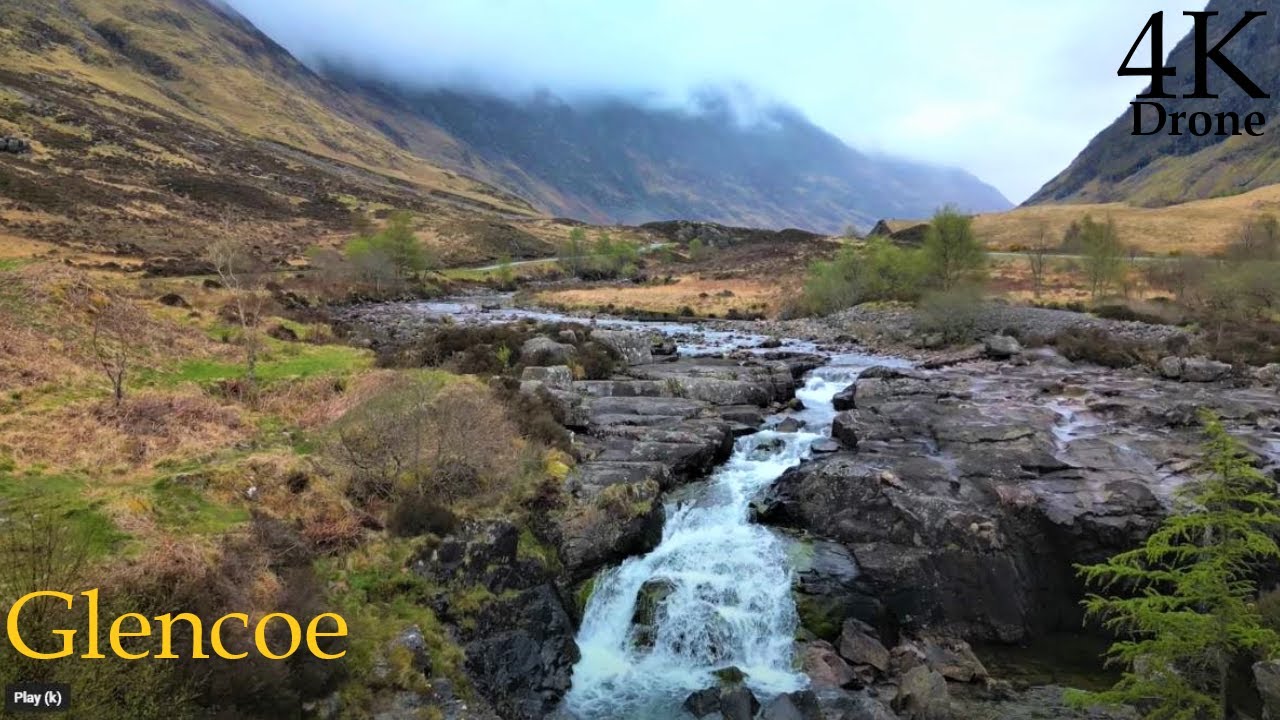
A Dreich Glencoe, Highland Scotland - April 2023 - DJI MINI3 Pro 4K
Автор: Albion Drones
Загружено: 2023-05-07
Просмотров: 420
Описание:
The last day, and the penultimate drone flights - from several locations in Glencoe - to try and capture some of the brooding majesty of this most hauntingly beautiful place...
I was able to ascend quite a way above my position, using the rule that allows me to fly up rto 120m above the nearest land in the vicinity of the drone - I set the max height to 800ft above my location and then ascended as the land rose to a heigh of about 1300ft above sea level, just short of the clouds..
For anyone who doesn't know, 'Dreich' is a Scottish word for a cold, wet and somewhat miserable day - and as corrected, it is spelt Dreich not Drecht, oops!
Drone - 'Mighty Midge' - DJI MINI3 Pro
Edited using - DaVinci Resolve 18 (beta)
Music - ES Duo Voces - Gavin Luke
From Wikipedia, the free encyclopedia
Glen Coe (Scottish Gaelic: Gleann Comhann pronounced [klan̪ˠˈkʰo.ən̪ˠ]) is a glen of volcanic origins, in the Highlands of Scotland. It lies in the north of the county of Argyll, close to the border with the historic province of Lochaber, within the modern council area of Highland. Glen Coe is regarded as the home of Scottish mountaineering and is popular with hillwalkers and climbers.
A 2010 review by Scottish Natural Heritage into the special qualities of Scotland's National scenic areas listed the "soaring, dramatic splendour of Glen Coe", and "the suddenness of the transition between high mountain pass and the lightly wooded strath" as being of note. The review also described the journey through the glen on the main A82 road as "one of the classic Highland journeys". The main settlement is the village of Glencoe located at the foot of the glen.
On 13 February 1692, in the aftermath of the Jacobite uprising of 1689, an incident known as the Massacre of Glencoe took place in the glen. Thirty-eight men from Clan MacDonald of Glencoe were killed by government forces who were billeted with them on the grounds that they had not been prompt in pledging allegiance to the new monarchs, William and Mary.
The Glen is named after the River Coe which runs through it. The name of the river may predate the Gaelic language, as its meaning is not known. It is possible that the name stems from an individual personal name, Comhan (genitive Comhain).
Geography
The glen is U-shaped, formed by an ice age glacier, about 12.5 kilometres (7+3⁄4 mi) long with the floor of the glen being less than 700 metres (3⁄8 mi) wide, narrowing sharply at the "Pass of Glen Coe".
The entrance to the glen from the east is below the foot of Buachaille Etive Beag just west of Lochan na Fola, from where waters run west to Loch Leven via the River Coe. The river—Ossian's "dark Cona" —passes over waterfalls at the Pass of Glen Coe before flowing down to the small Loch Achtriochtan. Loch Achtriochtan is Loch Trychardan (loch of the three friends or relatives) in Timothy Pont's map of the area. After the loch the river turns north-west, passing through Glencoe village, before flowing into the sea loch of Loch Leven (a salt-water arm of Loch Linnhe) at Invercoe.
The south side of the glen is marked by a succession of distinct peaks: Buachaille Etive Beag at the eastern end, followed by the Three Sisters, shoulders of the Bidean nam Bian massif which are subdivided by Coire Gabhail and Coire nan Lochan. The name Coire Gabhail (corrie of the bounty, or hollow of capture) refers to former times when the corrie was used by members of Clan MacDonald to hide cattle and other livestock, whether their own or stolen from others. The wide flat glen is well suited for this purpose since from Glen Coe it appears to be a normal v-shaped glen approached only by a steep narrow gorge. Summits in the Bidean nam Bian massif include Stob Coire Sgreamhach, Stob Coire nan Lochan and Aonach Dubh (the third "sister"). By contrast the north side of the glen is a stark wall of mountain, the Aonach Eagach ridge. The ridge is crossed at the eastern end by the Devil's Staircase, an old military road opposite Buachaille Etive Mòr. The western end terminates with the conical Pap of Glencoe, above Glencoe village, at the point where the glen opens out to Loch Leven.
Flora and fauna
Habitats within Glen Coe include birch woodland, moorland and peatbogs. The upland parts of the glen are one of the best habitats for alpine and sub-alpine plants in Lochaber, due to the underlying geology and range of altitude. Typical plants found on the highest slopes of the glen include lady's mantle, Sibbaldia procumbens and areas of willow scrub and Racomitrium lanuginosum moss-heath. In the lower areas of the glen bog myrtle, cotton grass, butterwort, sundew and bladderwort are to be found.
The peaks of the glen are home to snow bunting and ptarmigan, and the area also supports buzzards and golden eagles. The region also has an abundance of Highland midges, Culicoides impunctatus.
#scotland #landscape #cinematic #epic #djimini3pro #djiair3 #chillout #relaxing #landscapeandmusic #drone #highlands
Повторяем попытку...
Доступные форматы для скачивания:
Скачать видео
-
Информация по загрузке:


