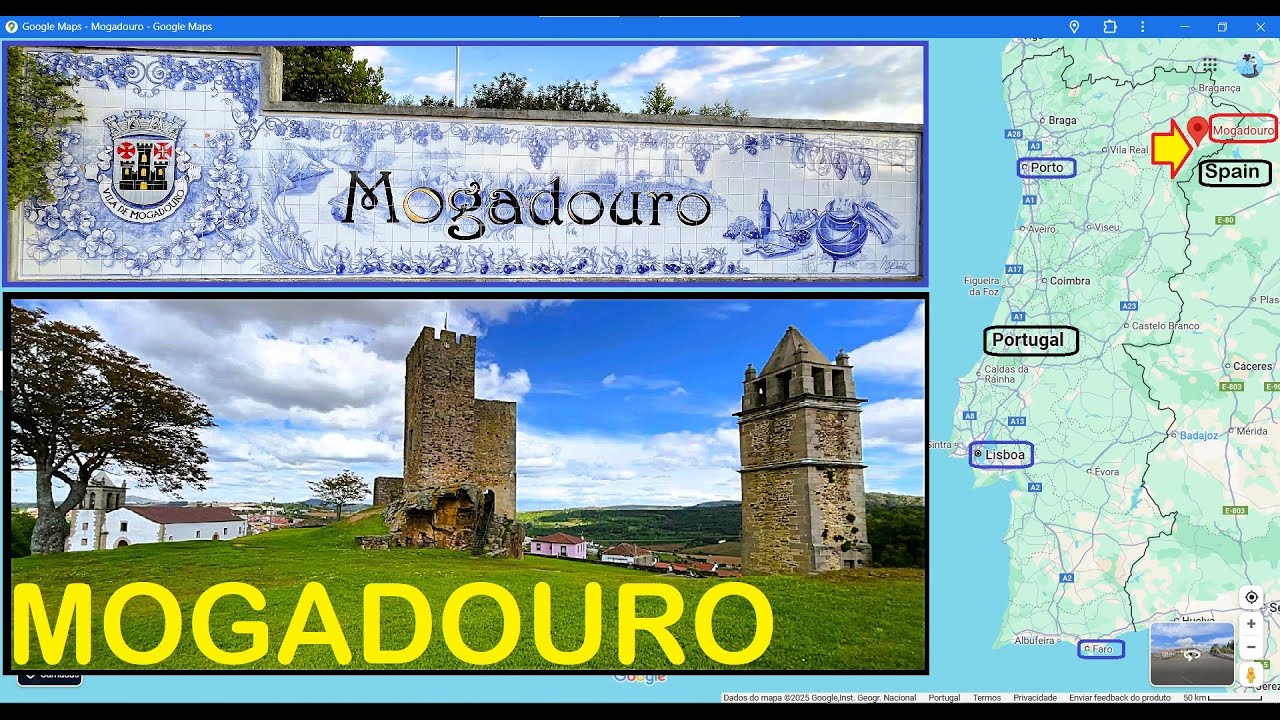
MOGADOURO »»» BRAGANÇA, Distrito; »»» MOGADOURO, Concelho
Автор: Portugal Profundo / Secret Portugal
Загружено: 2025-07-21
Просмотров: 284
Описание:
N 41.33529; W 6.71843
Mogadouro is a municipality in Portugal. The population in 2021 was 8,304 inhabitants in an area of 760.65 km².
The municipality of Mogadouro, situated in the Trás-os-Montes region of northeastern Portugal, is in the traditional district of Bragança. The northeastern municipalities of Vimioso, Macedo de Cavaleiros, Alfândega da Fé, Torre de Moncorvo and Freixo de Espada à Cinta are its limits. It is separated from the Spanish province of Castilla y León by the river valley of the Douro River, whose margins are cut by V-shaped inclines. The territory of Mogadouro is naturally delimited by the environment of the Rivers Douro and Sabor.
Mogadouro is also the seat for the Parque Natural do Douro Internacional (International Douro Natural Park), a protected wilderness that includes primarily the slopes of the Douro valley, but also lands designated as bird sanctuaries for species of eagle (specifically the Bonelli and golden eagles), the griffon and Egyptian vultures, and the rare black stork, in addition to the red-billed chough, the alpine swift and the black wheatear.
During the months of April and May, the flowering trees highlight the landscapes of many of the parishes. Mountain perennials (such as rosemary, Cytisus striatus and heather) are also common, although the Fagaceae (a species of beech) and holly oak, cork oak and juniper (which grow along the slopes of the Douro and Sabor valleys) are the predominant species.
Climate
The region is influenced by three climatic systems: the Atlantic, the Continent and the Mediterranean. So, its agriculture is varied and its landscape is full of contrasts. In the winter, the climate is rigorously cold and icy, with snowfall common throughout the period. In the summer, its is susceptible to torrid heat, typical of continental climates, that supports a dry vegetation.
Economy
Mogadouro is essentially a rural area, supported by agriculture and animal by-products. In addition to the primary sector, Mogadouro supports a diverse industrial sector, with warehouses, shops and industries linked to agriculture.
Cereal crops (in particular wheat) and forage allows the support of a large dairy industry. Mogadouro is one of the most productive milk suppliers in the north. Mogadouro is also a land known for almond production. Principally, in the fields of Valverde, Meirinhos, São Pedro, Souto, Roca, Santo André and São Martinho do Peso, these lands are covered in flowering trees seasonally, used in harvesting of the legumes.
(PT)
N 41,33529; W 6,71843
Mogadouro é um concelho de Portugal. A população em 2021 era de 8.304 habitantes numa área de 760,65 km².
O concelho de Mogadouro, situado na região de Trás-os-Montes, no nordeste de Portugal, situa-se no tradicional distrito de Bragança. Os concelhos de Vimioso, Macedo de Cavaleiros, Alfândega da Fé, Torre de Moncorvo e Freixo de Espada à Cinta são os seus limites. Está separada da província espanhola de Castela e Leão pelo vale fluvial do rio Douro, cujas margens são recortadas por declives em forma de V. O território de Mogadouro é naturalmente delimitado pela envolvente dos Rios Douro e Sabor.
Mogadouro é também a sede do Parque Natural do Douro Internacional, uma área selvagem protegida que inclui principalmente as encostas do vale do Douro, mas também terras designadas como santuários de aves para espécies de águias (especificamente a águia-de-bonelli e a águia-real), o grifo e o abutre-do-egito, e a rara cegonha-preta, além da gralha-de-bico-vermelho, do andorinhão-real e do chasco-preto.
Durante os meses de abril e maio, as árvores em flor realçam as paisagens de muitas das freguesias. As plantas perenes de montanha (como o rosmaninho, o Cytisus striatus e a urze) são também comuns, embora as Fagaceae (espécie de faia) e o azevinho, o sobreiro e o zimbro (que crescem ao longo das encostas dos vales do Douro e do Sabor) sejam as espécies predominantes.
Clima
A região é influenciada por três sistemas climáticos: o Atlântico, o Continente e o Mediterrâneo. Assim, a sua agricultura é variada e a sua paisagem repleta de contrastes. No inverno, o clima é rigorosamente frio e gélido, com queda de neve comum durante todo o período. No verão, é suscetível ao calor tórrido, típico dos climas continentais, que favorece uma vegetação seca.
Economia
Mogadouro é essencialmente uma zona rural, suportada pela agricultura e subprodutos animais. Para além do sector primário, Mogadouro alberga um sector industrial diversificado, com armazéns, lojas e indústrias ligadas à agricultura.
As culturas de cereais e as forragens permitem o desenvolvimento de uma grande indústria leiteira. Mogadouro é um dos fornecedores de leite mais produtivos do norte. É também uma terra conhecida pela produção de amêndoa. Principalmente nas terras de Valverde, Meirinhos, São Pedro, Souto, Roca, Santo André e São Martinho do Peso, estas terras estão cobertas por árvores sazonalmente floridas, utilizadas na apanha das leguminosas.
Повторяем попытку...
Доступные форматы для скачивания:
Скачать видео
-
Информация по загрузке:


![Alanya Mahmutlar Market – Fresh Finds at Turkey's Busiest Weekend Market | February 2026 [4K HD]](https://imager.clipsaver.ru/9YnvKXfmtp0/max.jpg)