Distance and Speed in Water - All about KNOTS and NAUTICAL ⚓ MILES
Автор: Offshore Surveys
Загружено: 2021-11-08
Просмотров: 2351
Описание:
Ancient mariners used to gauge the speed of their vessel by throwing a piece of wood or other floating object over the bow of the vessel and counting the time as the object passed through the stern. This method was known as a Dutchman’s log.
By the late 16th century, sailors had begun using a chip log to measure the speed. This is a pie-slice-shaped piece of wood, attached to a line and weighted down at on one end so that it can float vertically. This Chip Log presented substantial resistance to the water flowing around it. The chip log was cast over the stern of the vessel and the line was allowed to pay out. A series of Knots were made on the line at 47 feet 3 inches (14.40 m) from each other, and the line was allowed to passed through fingers of a sailor as the vessel was moving ahead. Meantime another sailor used a 30-second sand-glass to time the entire operation. This method gives a value for the knot as 20.25 in/s, or 1.85166 km/h or of you prefer metric system then it is 0.514444m/s or roughly 1.15 statute mile (per hour).
International nautical mile is used throughout the world. The measurement was set at exactly 1.852 kilometers in 1929 by what is now known as the International Hydrographic Organization. The U.S. and UK both used slightly different measurements but later both of them accepted the International nautical mile.U.S. adopted the international nautical mile in 1954 and the U.K. followed suit in 1970.
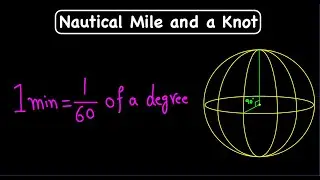
The distance in nautical miles between the equator and the poles is, by definition, 90 degrees times 60 minutes, or 5400 nautical miles, which is very close to 10000 kilometers.
This seems pretty plain, until we come across the fact that the earth is not a perfect sphere. It’s bloated at the equator and little bit squashed at the poles, and so it is known as an oblate spheroid. The Polar radius of the earth is 6356.752 kilometers and which is also known as the Semi Minor Axis. And at the equator, the radius is 6378.137 kilometers, which is also known as the Semi Major Axis. After various mathematical analyses in the 19th century, an Englishman named Alexander Ross Clarke came up with the idea of a spheroid, referred by scientists as the “figure of the earth,” which became the standard way of conceiving the shape of this Earth.
That oblateness of the Earth also messes with the nautical mile. If you take this shape into account, one minute of arc of latitude at the equator is 1842.9 meters; but at the north pole it is 1861.7 meters. In 1929, the (First) International Extraordinary Hydrographic Conference in Monaco decided to fix this value as 1852 meters or 6077 feet, as the length of the nautical mile. This compromise of the distances at the equator and the (North) poles works out to be the length of the nautical mile at 48 degrees of latitude.
The actual distance around the Earth at the Equator, is about 40,075 kilometers or roughly about 24,901 miles. So 1 equatorial minute is equivalent to 1855.4m. Though the Nautical Mile was defined based on the minute, it varies just a little from the equatorial minute.
Now that you might ask me how is the length of a meter is standardized or calculated? well...
The metre was originally defined in 1793 as one ten-millionth of the distance from the equator to the North Pole along a great circle. But the metre is currently defined as the length of the travelled by light in a vacuum which comes as 1/299 792 458 of a second.
One historical fact for you - The concepts of degrees, minutes, and seconds is taken from the Babylonian astronomy and time-keeping.
Influenced by the Sumerians, the ancient Babylonians divided the Sun's perceived motion across the sky over the course of one full day into 360 degrees. Each degree was subdivided into 60 minutes and each minute into 60 seconds.
Thus, one Babylonian degree is equivalent to four minutes in modern terminology, and one Babylonian minute to four seconds modern terminology.
#Knots #NauticalMiles #DutchmansLog #ChipLog #BabylonianAstronomy #StatuteMile #MillePassus
VERY USEFUL VIDEOS FOR SURVEYORS & MARINERS :
WHERE IS NORTH? • WHERE IS NORTH?
HOW TO Find Direction From SUN and Stars • What is Heading? HOW TO Find Direction at ...
What is Latitude and Longitude • Latitude & Longitude Explained with Angles...
How to Find Latitude and Longitude without GPS • How to Find Latitude and Longitude without...
Geodesy 101 | What is Geodesy? | What is Projection? • Geodesy Explained Simply | Earth Models, P...
Geodesy 101 - UTM Coordinate System | What Is Easting & Northing? • UTM Coordinate System Explained | Easting,...
Introduction to GPS | GPS 101 • How GPS Really Works: Satellites, Signals ...
00:00 Introduction
00:58 Dutchman's Log
01:14 Chip Log
02:03 Value of Knot
02:33 Nautical Mile
04:29 Oblate Spheroid
04:44 Radius of Earth
05:06 Figure of the Earth
05:26 Equatorial Minute
06:42 Length of a Meter?
07:14 Babylonian Astronomy
07:53 Outro & Thanks
Повторяем попытку...

Доступные форматы для скачивания:
Скачать видео
-
Информация по загрузке: