HUGE Tornado Day - Storm Chasers On The Ground
Автор: Reed Timmer
Загружено: 2026-06-12
Просмотров: 281934
Описание:
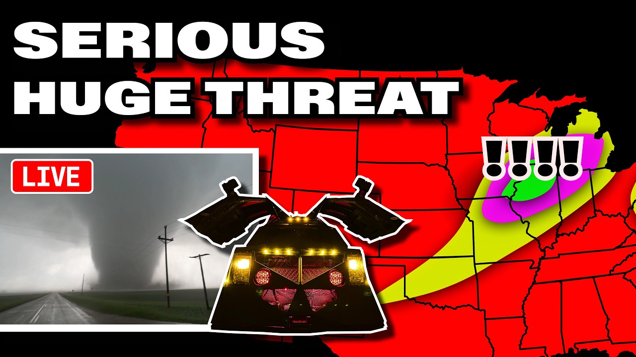
🌪️ SEVERE WEATHER OUTLOOK – Thursday, June 11, 2026 (11:22Z Update)
SPC Risk Level: MODERATE (Level 4 of 5)
Valid through June 11, 2026 7:00 PM CDT Thursday
📍 Major Cities in Risk Zones
🔴 MODERATE Risk: Rockford, IL, Cedar Rapids, IA, Madison, WI, Janesville, WI, Dubuque, IA , Chicago, IL
🟡 SLIGHT Risk: Indianapolis, IN, Detroit, MI, Harrisburg, PA, Richmond, VA
🟢 MARGINAL Risk: Kansas City, MO, Topeka, KS, Louisville, KY, Charleston, WV
🌪️ Tornado Risk Zones
🔴 15% Tornado Risk (supercells with potential for strong to intense tornadoes): Rockford, IL, Cedar Rapids, IA, Madison, WI, Janesville, WI
🟢 2% Tornado Risk (embedded QLCS tornado threat with bowing segments): Indianapolis, IN, Detroit, MI, Dubuque, IA, Madison, WI
What the Percentages Mean
A 15% tornado risk means there is a 1 in 7 chance of a tornado within 25 miles of a point. This highest risk zone includes the potential for multiple tornadic supercells, some of which may produce strong to intense tornadoes (EF-2/3+).
📝 Overview
An active and impactful severe weather event is expected this afternoon and evening across parts of the Midwest and Great Lakes region, including far eastern Iowa, northern Missouri, northern and central Illinois, southern Wisconsin, Lower Michigan, and northern Indiana. A potent shortwave trough over the northern Plains and Upper Midwest will enhance mid-level west-southwesterly winds, supporting organized severe potential.
Ongoing convection across southeast Iowa, northwest Illinois, and southwest Wisconsin may continue to produce severe wind gusts and embedded tornadoes as it moves east-northeastward. Ahead of this activity, strong heating and airmass recovery will increase instability, especially across central and northern Illinois, northern Indiana, and southern Lower Michigan.
Renewed thunderstorms are expected to develop along and ahead of the surface cold front this afternoon in a strongly unstable and favorably sheared environment. A mix of supercells and bowing segments is likely, with the potential for several tornadoes, including some strong to intense tornadoes, as well as isolated large hail. Widespread damaging winds, some exceeding 75 mph, are also anticipated.
Additional thunderstorms will develop this afternoon and evening along the trailing cold front into eastern Kansas, southern Missouri, and the southern Plains. Marginally favorable shear and moderate to strong instability will support marginal supercells and multicell clusters capable of large hail and damaging winds.
Widely scattered thunderstorms are also expected across parts of the Mid-Atlantic and central Appalachians due to moderate instability and modest shear. These storms may produce scattered damaging winds and isolated hail, especially along the I-95 corridor from northern Virginia to eastern Pennsylvania and New Jersey.
⛈️ Hazards Include
🧊 Large to very large hail (isolated very large hail possible with supercells)
🌪️ Several tornadoes possible, including strong to intense tornadoes (EF-2/3+)
💨 Widespread damaging winds, some exceeding 75 mph, in both bowing segments and supercells
🕓 Timeline
12 PM–3 PM CDT: Ongoing convection across southeast IA, northwest IL, and southwest WI continues with severe wind and embedded tornado threat
3 PM–7 PM CDT: Redevelopment of thunderstorms along/ahead of cold front with supercells and bowing segments producing tornadoes, large hail, and damaging winds
7 PM–12 AM CDT: Severe threat diminishes eastward into southern Great Lakes and northern Indiana; storms weaken overnight
📌 Regional Notes
🔴 Midwest/Great Lakes → Northern Illinois, Eastern Iowa, Southern Wisconsin: Potential for widespread damaging winds and strong to intense tornadoes
🟡 Mid-Atlantic/Central Appalachians → Northern Virginia to Eastern Pennsylvania and New Jersey: Scattered damaging winds and isolated hail possible
🟢 Southern Plains → Eastern Kansas and Southern Missouri: Marginal severe threat with large hail and damaging winds in multicell clusters
⚠️ Stay Weather-Aware
Residents across northern Illinois, far eastern Iowa, southern Wisconsin, and adjacent areas should remain alert this afternoon and evening for rapidly changing severe weather conditions, including the potential for strong tornadoes and widespread damaging winds. Stay tuned to local forecasts and be prepared to take shelter if warnings are issued.
———————————
In-Vehicle
Driver, Man-of-Action - @ReedTimmerWx
Navigator, Man-of-Music - @localmanweatherofficial
Engineer, Man-of-Iron - @willclay25
Studio
Guy in the corner - @brianvotoole, but he doesn't really post anything. he's just laying in the cut, you know?
Thanks United Cajun Navy - https://unitedcajunnavy.org/
Повторяем попытку...
Доступные форматы для скачивания:
Скачать видео
-
Информация по загрузке: