ycliper

Популярное

Музыка Кино и Анимация Автомобили Животные Спорт Путешествия Игры Юмор

Интересные видео

2025 Сериалы Трейлеры Новости Как сделать Видеоуроки Diy своими руками

Топ запросов

смотреть а4 schoolboy runaway турецкий сериал смотреть мультфильмы эдисон
Скачать

How to Create Sections in Civil 3D from Level Book Data | Road Section with Station,Offset&Elevation

Автор: Horizon Civil Techniques

Загружено: 2025-03-08

Просмотров: 1772

Описание: Detailed Description:
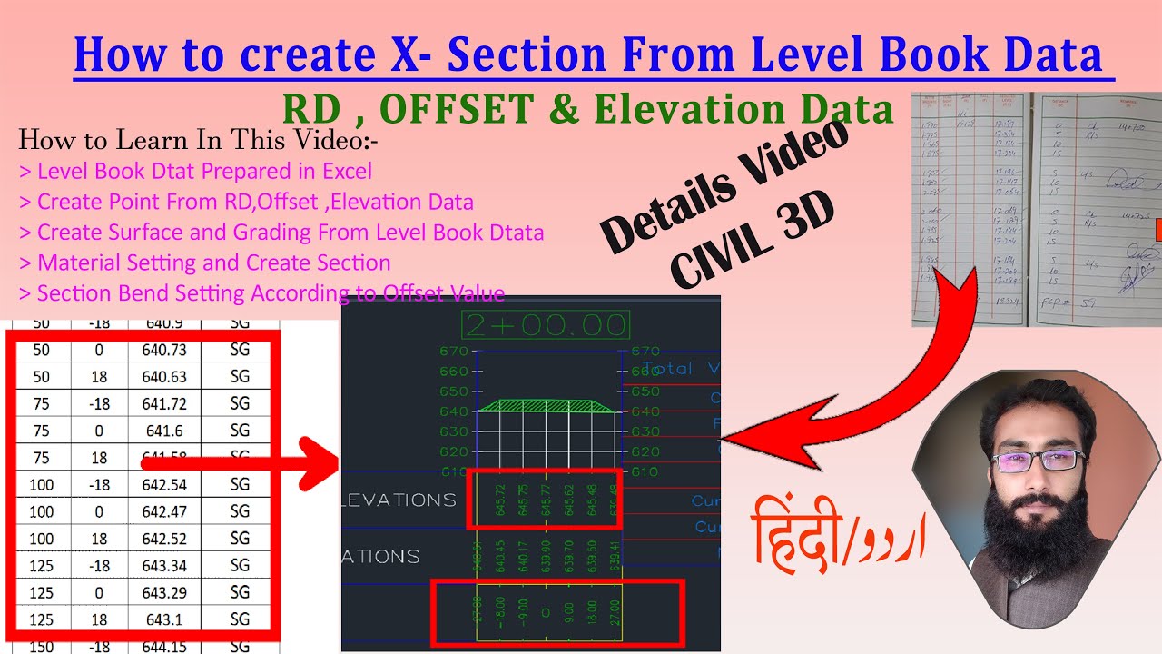
In this comprehensive AutoCAD Civil 3D tutorial, learn how to create road cross sections from Level Book data collected using Auto Level, MLM (Mean Line Method), or Total Station. This video provides a step-by-step workflow to process survey data, generate surfaces, and create accurate cross sections in Civil 3D.

🔹 What You Will Learn in This Video:
1️⃣ Preparing Level Book Data in Excel

Organizing Station (RD), Offset, and Elevation Data
Formatting survey data for easy import into Civil 3D
2️⃣ Creating Points from Survey Data

Importing Station, Offset, and Elevation values into Civil 3D
Using Point Groups to categorize data efficiently
3️⃣ Generating Surfaces from Level Book Data

Creating surfaces from survey points
Merging multiple surfaces for accurate terrain representation
4️⃣ Feature Line and Grading Techniques

Creating Feature Lines for better section accuracy
Applying grading tools to define slope transitions
5️⃣ Material Setting for Cross Sections

Assigning pavement layers, subgrade, and base materials
Managing material thickness and properties
6️⃣ Profile and Sample Line Creation

Generating profiles along the alignment
Adding sample lines to extract cross-section data
7️⃣ Generating Cross Sections in Civil 3D

Creating cross sections automatically
Managing section band styles according to Offset values
8️⃣ Final Customization and Presentation

Adjusting Bend Styles for better visualization
Formatting cross sections for plotting and exporting
💡 Why Watch This Video?
✅ Complete Road Cross-Section Workflow – From survey data to final output
✅ Real Survey Data Processing – Learn using real-world Level Book data
✅ AutoCAD Civil 3D Best Practices – Improve design accuracy and efficiency
✅ Perfect for Road Designers, Civil Engineers & Surveyors

This tutorial will help surveyors, CAD professionals, and civil engineers efficiently process survey data and generate accurate road cross sections in AutoCAD Civil 3D.

🔔 Subscribe now for more Civil 3D tutorials and stay updated with new tips!
#AutoCADCivil3D #CrossSection #SurveyData #LevelBook #RoadDesign #CivilEngineering #Surveying #CADDesign #LandDevelopment #Civil3DTutorial #autocadtips

Time code
0:00 Intro About Details Video
2:47 Excel Data Setting
13:10 Point Group Separation
19:20 Create Surfaces
20:50 Feature Line
25:18 Grading
29:39 Surface Merge
30:39 Create Profile
31:42 Sample Line
36:30 Material Add
37:36 Create Section
41:44 Bend Style Setting

How to Create Multiple Point Groups in Civil 3D Based on Code & Description | Survey Data Management    • How to Create Multiple Point Groups in Civ...  

What is Sample Line | How to Create Sample Line in AutoCAD Civil 3D | 4 Ways for Different Purposes    • What is Sample Line | How to Create Sample...  


[email protected]
#Autocad
#AutocadCivil3D
#RealTimeCad
#autodesk

Не удается загрузить Youtube-плеер. Проверьте блокировку Youtube в вашей сети.
Повторяем попытку...
How to Create Sections in Civil 3D from Level Book Data | Road Section with Station,Offset&Elevation

Поделиться в:

Доступные форматы для скачивания:

Скачать видео

  • Информация по загрузке:

Скачать аудио

Похожие видео

How to create and Modify Cross Section Band style in Civil3d | Grade Break  Cross section Bend

How to create and Modify Cross Section Band style in Civil3d | Grade Break Cross section Bend

SW DTM TUTORIAL

SW DTM TUTORIAL

Autodesk Civil 3d: How to create/Generate plan profile sheet for roadway design

Autodesk Civil 3d: How to create/Generate plan profile sheet for roadway design

Topographic Survey With Total station

Topographic Survey With Total station

How to Make Road Cross Section in Civil3D Part 40 | Cross Section Creation #civil3d  #autocadcivil3d

How to Make Road Cross Section in Civil3D Part 40 | Cross Section Creation #civil3d #autocadcivil3d

Coordinate Calculations

Coordinate Calculations

Маркировка и изменение поперечного сечения в Autodesk Civil 3D

Маркировка и изменение поперечного сечения в Autodesk Civil 3D

Most Ridiculous Worker Mistakes Caught on Camera

Most Ridiculous Worker Mistakes Caught on Camera

Assim era a Vida no Mundo ANTES DO DILÚVIO há 5.000 Anos | (DOCUMENTÁRIO)

Assim era a Vida no Mundo ANTES DO DILÚVIO há 5.000 Anos | (DOCUMENTÁRIO)

Долбануть по Ирану, отжать Гренландию | Обычный вторник Трампа? (English subtitles)

Долбануть по Ирану, отжать Гренландию | Обычный вторник Трампа? (English subtitles)

Расчет средних объемов выемки и насыпи в конечной зоне с помощью Civil 3D

Расчет средних объемов выемки и насыпи в конечной зоне с помощью Civil 3D

How to calculate CUT Fill volume in Civil 3D | Plot Excavation As Build With Design Side Slop.

How to calculate CUT Fill volume in Civil 3D | Plot Excavation As Build With Design Side Slop.

Civil 3D 2021 steps to create a Corridor with | Alignment | Profile | Assembly | Cut/Fill & Sections

Civil 3D 2021 steps to create a Corridor with | Alignment | Profile | Assembly | Cut/Fill & Sections

Как добавить контурные линии на поверхность в AutoCAD Civil 3D

Как добавить контурные линии на поверхность в AutoCAD Civil 3D

НАЧАЛО ГОДА СУЛИТ НОВЫЕ ПРОБЛЕМЫ YOUTUBE, GOOGLE и отключения ИНТЕРНЕТА. Разбираем важное

НАЧАЛО ГОДА СУЛИТ НОВЫЕ ПРОБЛЕМЫ YOUTUBE, GOOGLE и отключения ИНТЕРНЕТА. Разбираем важное

How To Useing Observation Function in Total Station | Topography survey Kaise Karte he | Observation

How To Useing Observation Function in Total Station | Topography survey Kaise Karte he | Observation

How to Create in Civil 3D Assembly Corridor Sample Lines & Cross Sections. With Distance & Elevation

How to Create in Civil 3D Assembly Corridor Sample Lines & Cross Sections. With Distance & Elevation

Import & Create Data File for Work Done Cross Section | AutoCAD Civil 3D in Hindi & Urdu | PART-120

Import & Create Data File for Work Done Cross Section | AutoCAD Civil 3D in Hindi & Urdu | PART-120

Civil3D, setting label cross section

Civil3D, setting label cross section

Экстремальный способ переработки использованных шин и коровьих костей на пакистанской фабрике

Экстремальный способ переработки использованных шин и коровьих костей на пакистанской фабрике

© 2025 ycliper. Все права защищены.


  • Контакты
  • О нас
  • Политика конфиденциальности


Контакты для правообладателей: [email protected]