#4 Methods of calculating average rainfall | Water Resources Engineering | SBTE Bihar
Автор: Diploma & IGNOU Junction
Загружено: 2024-07-21
Просмотров: 1797
Описание:
In this video lecture, different methods to calculate average rainfall is used.
Notes regarding this lecture
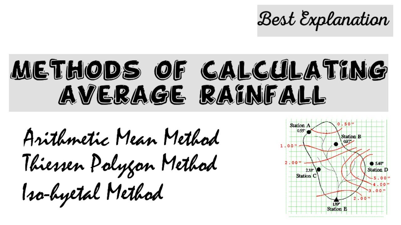
METHODS OF CALCULATING AVERAGE RAINFALL
One raingauge station cannot represent a large basin. So, a basin is
always composed of many raingauge stations which are evenly distributed
throughout the whole basin.
• Again, the amount of rainfall may not be equal in all raingauge stations.
Since, the average rainfall of the basin is required for estimating the runoff from the basin, it is customary to apply any suitable method to
determine the average depth of precipitation.
• The following three methods are generally adopted to calculate the
average depth of precipitation.
1) Arithmetic Mean Method
2) Thiessen Polygon Method
3) Iso-hyetal Method
1. Arithmetic Mean Method
• This method is very simple. In this method the rainfall values obtained
from all the raingauge stations are added and divided by the number of
stations to get the average value.
• Suppose, N is the number of stations and R1
, R2
, R3 etc. are the rainfall
values obtained from the stations.
Then, average depth of precipitation =
R1 + R2 + R3...
𝐍
• This method is reliable to get the accurate value of average precipitation.
when the raingauge stations are uniformly distributed over the basin.
2. Thiessen Polygon Method
• This method is highly suitable for large areas.
• It is based on the assumption that each raingauge
station has its own domain within the basin area.
• That domain may be defined by geometrical
construction as follows.
Suppose, A, B, C, D, E and F are the raingauge
stations. All the stations are joined by dotted lines
to form a number of triangles.
The perpendicular bisectors are drawn to each
sides of the triangles. Thus a closed polygon abcde
is formed which indicates the domain of the
raingauge station A.
Similarly, all the other raingauge stations within the basin are joined to form
triangles. The perpendicular bisectors are drawn as above. Thus, a number of
polygons are formed.
Geometrically, it can be proved that each polygon represents the domain of each
raingauge station.
The area of each polygon is measured by graph paper or by planimetre.
The result is then tabulated as follows:
3. Iso-hyetal Method
• A Iso-hyet line represents a line joining the points of
equal depth of precipitation. So, it is just like a
contour line.
• In this method, all the raingauge stations are located
within the map of the required basin.
• Then depth of precipitation of all the stations are
noted at the respective station point.
• Now, the Iso-hyet lines are drawn at 1 cm interval by
the method of interpolation (as done during the
plotting of contour lines)
• The area enclosed between the two successive Isohyet lines is found out by graph paper or by
planimeter.
Повторяем попытку...
Доступные форматы для скачивания:
Скачать видео
-
Информация по загрузке: