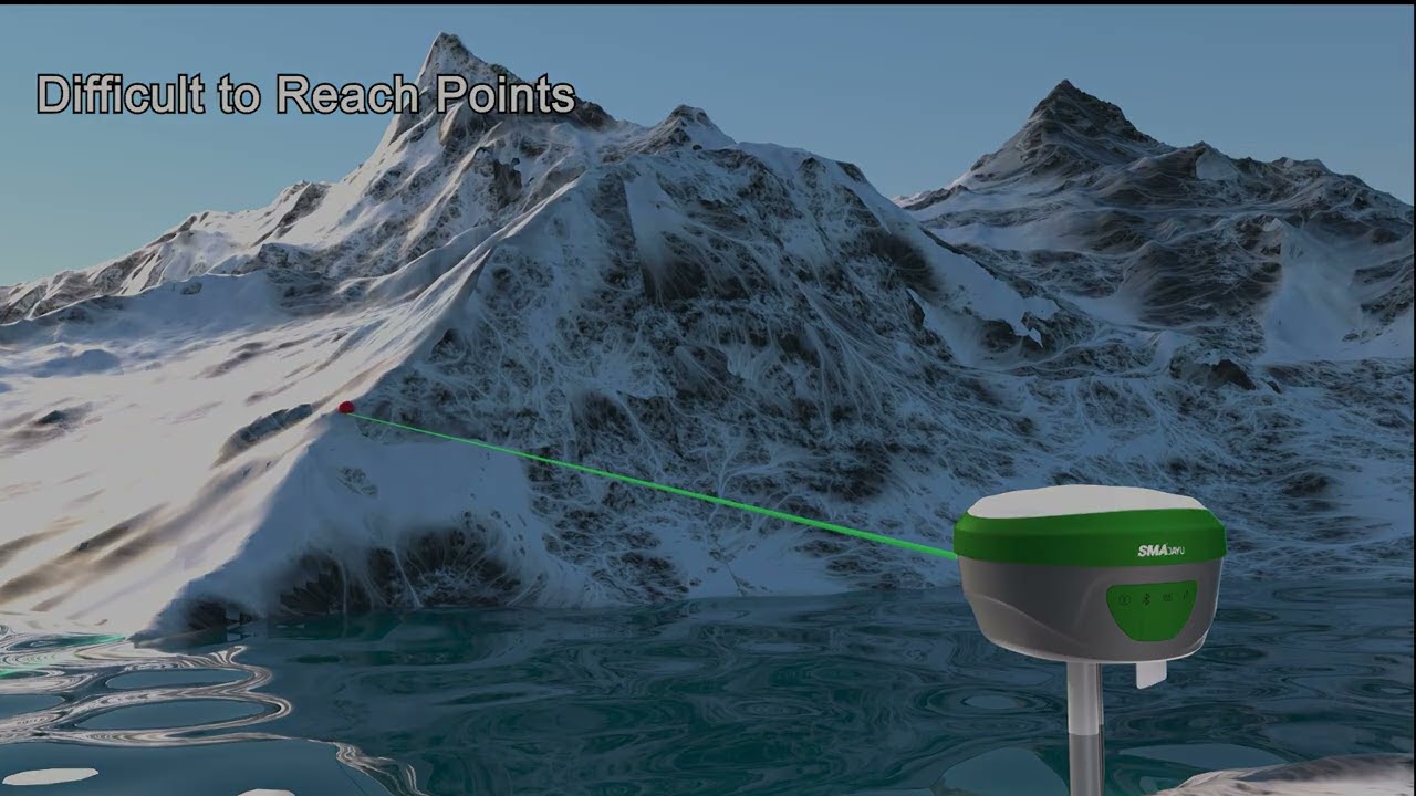
SMA28H Laser RTK GNSS surveying equipment
Автор: SMAJAYU
Загружено: 2025-07-29
Просмотров: 8285
Описание:
SMA28H Laser RTK GNSS – Precision Where You Can See
The SMA28H Laser RTK GNSS Survey System is a next-generation surveying solution that integrates laser-based, non-contact point measurement with AR visual stakeout and full-constellation GNSS positioning. Designed for engineers, land surveyors, and field professionals, SMA28H enables users to capture precise coordinates from visible but hard-to-reach locations—such as wall edges, building corners, and surfaces with height or access limitations.
The built-in green laser module allows users to aim at the measurement point without making physical contact. Combined with dual 5MP HD cameras, the system supports real-time visual confirmation and targeting, ensuring accuracy and efficiency in layout and data collection.
SMA28H supports 1408 GNSS channels across GPS, BDS, GLONASS, Galileo, and QZSS constellations. With an integrated inertial navigation module, it delivers 2.5 cm tilt survey accuracy within 30°, and up to 120° tilt angle support. Rugged and reliable, the receiver is IP67-rated, drop-resistant, and equipped with a 7000 mAh battery for long field sessions.
Key Features:
✔️ Laser Measurement: Measure precise coordinates (3–4 cm accuracy) from visible but difficult-to-access points, up to 15 meters away.
✔️ Dual HD Cameras: 5MP wide-angle front and side cameras enhance visual targeting and AR layout functionality.
✔️ AR Stakeout: Identify and mark stakeout points visually using real-time video overlay.
✔️ Tilt Compensation: Supports tilt up to 120°; 2.5 cm accuracy within 30° using integrated IMU.
✔️ Multi-Constellation GNSS: 1408-channel tracking of all major satellite systems.
✔️ Robust Field Design: Withstands drops up to 1.8 meters; waterproof and dustproof (IP67).
✔️ Smart Connectivity: Integrated 4G LTE, WiFi, UHF radio, Bluetooth, NFC, and mobile-accessible WEBUI for flexible field setup.
SMA28H – Precision measurement without contact. Ideal for construction, topographic mapping, and survey work requiring access to elevated, recessed, or hard-to-reach but visible targets.
Повторяем попытку...
Доступные форматы для скачивания:
Скачать видео
-
Информация по загрузке:


![Top 5 Best GPS Survey Equipment 2025 | Best GPS Survey Equipment 2025 | [Best Picks]](https://imager.clipsaver.ru/xWCkj390fWM/max.jpg)


