HEADS UP! BIG Tornado Day 1/3 - Live Chasers
Автор: Reed Timmer
Загружено: 2026-06-10
Просмотров: 296366
Описание:
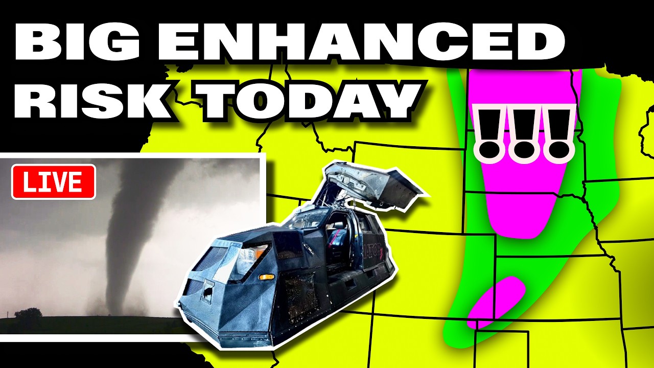
🌪️ SEVERE WEATHER OUTLOOK – Tuesday, June 9, 2026 (11:35AM CDT Update)
SPC Risk Level: ENHANCED (Level 3 of 5)
Valid through June 9, 2026 7:00 PM CDT Tuesday
📍 Major Cities in Risk Zones
🟠 ENHANCED Risk: Sioux Falls, SD, Grand Island, NE, Lincoln, NE, Aberdeen, SD
🟡 SLIGHT Risk: Memphis, TN, Little Rock, AR, Springfield, MO, St. Louis, MO
🌪️ Tornado Risk Zones
🔴 15% Tornado Risk (Discrete supercells with strong tornado potential): Aberdeen, SD, Sioux Falls, SD, Norfolk, NE, Yankton, SD
🟡 10% Tornado Risk (Embedded tornadoes within linear storms and discrete cells): Lincoln, NE, Sioux City, IA, Sioux Falls, SD, Yankton, SD
🟢 2% Tornado Risk (Marginal tornado threat within broader severe threat): Memphis, TN, Little Rock, AR, Springfield, MO, St. Louis, MO
What the Percentages Mean
A 15% tornado risk means there is a 1 in 7 chance of a tornado within 25 miles of a point. The highest risk area across the northern and central Plains features supercell storms capable of producing strong tornadoes, large hail, and damaging wind gusts.
📝 Overview
A negatively tilted upper trough over the northern and central Plains will promote widespread severe thunderstorms this afternoon and evening. Very strong instability with MLCAPE exceeding 2500 J/kg, and locally above 4000 J/kg, will support intense convection. A cold front and dryline will serve as the focus for storm initiation from the western Dakotas southward into western Nebraska.
Storms will initially develop as discrete supercells with the potential for strong tornadoes, large hail, and damaging winds. As the evening progresses, storms are expected to organize into fast-moving convective lines producing widespread damaging wind gusts exceeding 75 mph. Embedded tornadoes will remain possible within these lines, especially in eastern portions of the risk area.
Additional severe storms with damaging winds and large hail are expected from north-central and west-central Kansas southwestward into the Texas Panhandle. A slight risk extends into the Lower Mississippi Valley where an MCV will trigger storms capable of damaging gusts and a low tornado threat.
⛈️ Hazards Include
🧊 Very large hail (up to baseball size or larger possible with supercells)
🌪️ Tornadoes (some potentially strong and long-lived)
💨 Damaging wind gusts (60-80+ mph, especially within convective lines)
🕓 Timeline
12 PM–4 PM CDT: Storm initiation near cold front and dryline across western Dakotas and Nebraska
4 PM–8 PM CDT: Peak severe threat with supercells and convective lines moving eastward across northern and central Plains
8 PM–12 AM CDT: Transition to linear convection with widespread damaging winds and embedded tornadoes eastward into Upper Midwest
📌 Regional Notes
🟠 Northern and Central Plains → SD, NE: Enhanced risk for strong tornadoes, very large hail, and damaging winds
🟡 Lower Mississippi Valley → AR, TN, MO: Slight risk for damaging winds and isolated tornadoes with MCV-driven storms
🟢 Texas Panhandle → TX, OK: Marginal risk for large hail and damaging winds with high-based storms
⚠️ Stay Weather-Aware
Residents across South Dakota, Nebraska, and surrounding Plains states should remain alert for rapidly developing severe thunderstorms this afternoon and evening. Conditions favor strong tornadoes, very large hail, and damaging winds. Stay tuned to local warnings and be prepared to take shelter if severe weather approaches.
———————————
In-Vehicle
Driver, Man-of-Action - @ReedTimmerWx
Navigator, Man-of-Music - @localmanweatherofficial
Engineer, Man-of-Iron - @willclay25
Studio
Guy in the corner - @brianvotoole, but he doesn't really post anything. he's just laying in the cut, you know?
Thanks United Cajun Navy - https://unitedcajunnavy.org/
Повторяем попытку...
Доступные форматы для скачивания:
Скачать видео
-
Информация по загрузке: