ycliper

Популярное

Музыка Кино и Анимация Автомобили Животные Спорт Путешествия Игры Юмор

Интересные видео

2025 Сериалы Трейлеры Новости Как сделать Видеоуроки Diy своими руками

Топ запросов

смотреть а4 schoolboy runaway турецкий сериал смотреть мультфильмы эдисон
Скачать

NASA ARSET: Operational Crop Classification Roadmap using Optical and SAR Imagery 2, Part 4/5

nasa

arset

Автор: NASA Video

Загружено: 2021-10-15

Просмотров: 7159

Описание: Agricultural Crop Classification with Synthetic Aperture Radar and Optical Remote Sensing: Intermediate Webinar

Part 4: Operational Crop Classification Roadmap using Optical and SAR Imagery 2

Instructors: Georgia Karadimou & Tereza Roth (RUS)

Explanation of Random Forest, Support Vector Machine, and Unsupervised algorithms as classifiers
Explain Python libraries for running classifiers in JupyterLab
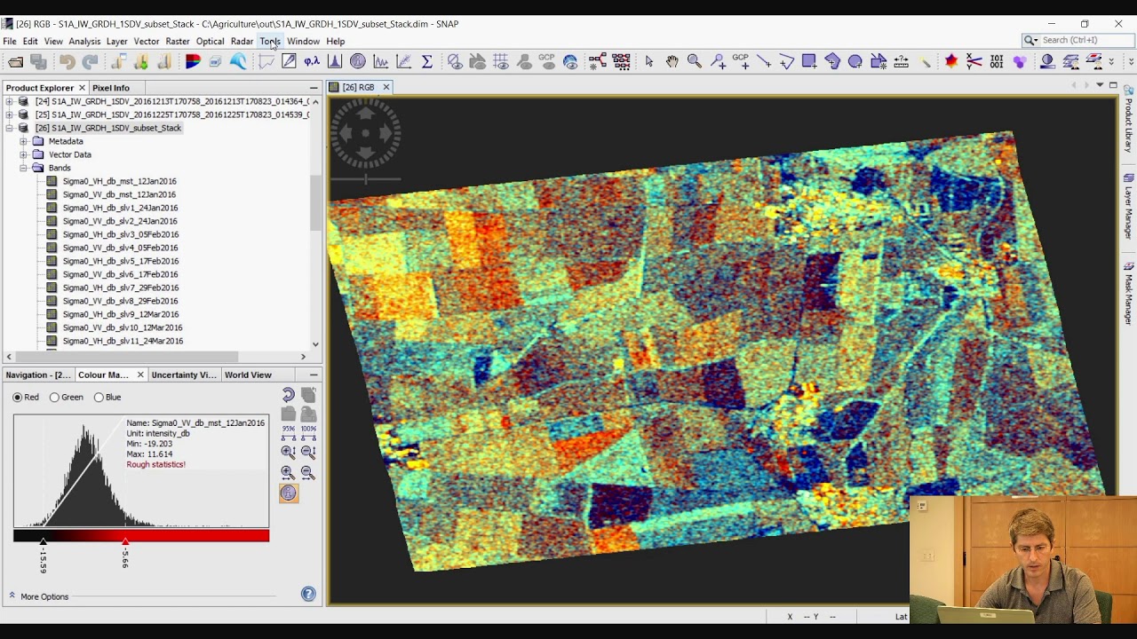
Use of SNAP and Python for crop classification, including demonstration of different parameters (e.g., S1 vs. S2 alone) when classifying crop types in a given study area
Q&A

If you would like to follow along with the demonstrations in Part 4, please:

Request the Training kit containing the Jupyter Notebook, environment setup, install instructions and training data by sending an e-mail to: [email protected] (Please specify that you are requesting the Training kit and include the name of the webinar series.

Exercise Steps: http://appliedsciences.nasa.gov/sites...

Download the Processing Data: https://drive.google.com/file/d/156ha...

You can access all training materials from this webinar series on the training webpage: https://appliedsciences.nasa.gov/join...

This training was created by NASA's Applied Remote Sensing Training Program (ARSET), in partnership with Agriculture and Agri-Food Canada (AAFC), European Space Agency (ESA), Indian Space Research Organisation (ISRO), United Nations Office for Outer Space Affairs (UNOOSA), and the CEOS Working Group on Capacity Building & Data Democracy (WGCapD). ARSET is a part of NASA's Applied Science's Capacity Building Program. Learn more about ARSET: https://appliedsciences.nasa.gov/what...

Не удается загрузить Youtube-плеер. Проверьте блокировку Youtube в вашей сети.
Повторяем попытку...
NASA ARSET: Operational Crop Classification Roadmap using Optical and SAR Imagery 2, Part 4/5

Поделиться в:

Доступные форматы для скачивания:

Скачать видео

  • Информация по загрузке:

Скачать аудио

Похожие видео

NASA ARSET: Biophysical Variable Retrieval using Optical Imagery for Agriculture, Part 5/5

NASA ARSET: Biophysical Variable Retrieval using Optical Imagery for Agriculture, Part 5/5

NASA ARSET: Overview of Machine Learning, Part 1/3

NASA ARSET: Overview of Machine Learning, Part 1/3

ESA Echoes in Space - Land: Crop type mapping with Sentinel-1

ESA Echoes in Space - Land: Crop type mapping with Sentinel-1

NASA ARSET: Operational Crop Classification Roadmap using Optical and SAR Imagery, Part 3/5

NASA ARSET: Operational Crop Classification Roadmap using Optical and SAR Imagery, Part 3/5

СРОЧНЫЕ НОВОСТИ ИЗ МЮНХЕНА! Не поверите, что СЛУЧИЛОСЬ. ФЕЙГИН, БЕЛКОВСКИЙ разложили все ПО ПОЛОЧКАМ

СРОЧНЫЕ НОВОСТИ ИЗ МЮНХЕНА! Не поверите, что СЛУЧИЛОСЬ. ФЕЙГИН, БЕЛКОВСКИЙ разложили все ПО ПОЛОЧКАМ

Сможет ли новый ИИ от Google решить все проблемы? | Титаны и новаторы

Сможет ли новый ИИ от Google решить все проблемы? | Титаны и новаторы

🎙 Честное слово с Сергеем Жирновым

🎙 Честное слово с Сергеем Жирновым

Part 1/4: SAR Polarimetry: Basics and Advanced Concepts - Prof. Eric Pottier (theory)

Part 1/4: SAR Polarimetry: Basics and Advanced Concepts - Prof. Eric Pottier (theory)

Российская армия может дойти до Москвы – Игаль Левин

Российская армия может дойти до Москвы – Игаль Левин

Катастрофа в столице / Захват Киева Россией?

Катастрофа в столице / Захват Киева Россией?

МЮНХЕН: РАЗВЕДЁТСЯ ЛИ АМЕРИКА С ЕВРОПОЙ? БЕСЕДА СО СТАНИСЛАВОМ БЕЛКОВСКИМ @BelkovskiyS

МЮНХЕН: РАЗВЕДЁТСЯ ЛИ АМЕРИКА С ЕВРОПОЙ? БЕСЕДА СО СТАНИСЛАВОМ БЕЛКОВСКИМ @BelkovskiyS

Multispectral Imagery Analysis

Multispectral Imagery Analysis

Methods for cropland/crop type mapping from S2 and/or S1 time series - Day 2.2

Methods for cropland/crop type mapping from S2 and/or S1 time series - Day 2.2

NASA ARSET: Synthetic Aperture Radar (SAR) Refresher, Part 1/5

NASA ARSET: Synthetic Aperture Radar (SAR) Refresher, Part 1/5

Satellites for Agriculture: Application of Artificial Intelligence for Satellite Imagery in Farming

Satellites for Agriculture: Application of Artificial Intelligence for Satellite Imagery in Farming

Crop Type Mapping with Deep Learning using Tensor Flow

Crop Type Mapping with Deep Learning using Tensor Flow

NASA ARSET: Crop Classification with Time Series of Polarimetric SAR Data, Part 1/3

NASA ARSET: Crop Classification with Time Series of Polarimetric SAR Data, Part 1/3

Analyze floods using ONLY Python! (aka spatial data science)

Analyze floods using ONLY Python! (aka spatial data science)

PolInSAR & Biomass 2023 - Day 1

PolInSAR & Biomass 2023 - Day 1

NASA ARSET: Crop Classification with Time Series Optical and Radar Data, Part 2/3

NASA ARSET: Crop Classification with Time Series Optical and Radar Data, Part 2/3

© 2025 ycliper. Все права защищены.


  • Контакты
  • О нас
  • Политика конфиденциальности


Контакты для правообладателей: [email protected]