December 2025 Monthly Weather Summary
Автор: NWSGrandJunction
Загружено: 2026-01-14
Просмотров: 22
Описание:
December 2025 Monthly Weather Summary
---------------------------------
For a written December 2025 weather summary, please visit our website at https://www.weather.gov/media/gjt/Dec...
---------------------------------
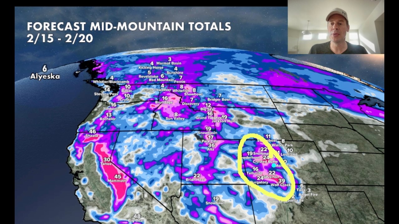
December started out with seasonable to below seasonable temperatures. Some of the coldest temperatures of the month and of the 2025/2026 winter season occurred in the first week of December. Additionally, a potent winter storm brought close to a foot of snow to the mountains. A secondary system a few days later brought another shot of snow and strong, gusty winds that made for difficult travel. Unsettled weather lingered through the month, but mostly brought light snowfall to the northern mountains without much in the way of accumulations. While the mountains saw continued bursts of light snow, the valleys remained high and dry through much of the month. Temperatures also did not stay cold, with highs climbing well above normal by the middle of the month. By the week of Christmas, eastern Utah and western Colorado were staring down record setting temperatures, with highs close to 20 degrees above normal. The lower desert valleys saw highs in the low to mid-60s, while higher valleys saw temperatures in the 50s. Between the 26th and 29th, a stronger and colder system brought substantial mountain snow, valley rain, and even some valley snow. Temperatures dropped near to below normal, although they did warm right back up for the 30th. On the last day of the month a weaker but still cold system swung through, bringing a last round of precipitation to send off 2025.
The month of December was overall warmer than normal, with all ten of the automated weather observation stations located at airports across eastern Utah and western Colorado finishing the month with above normal mean temperatures. Mean temperature departures ranged from 7.4F to 14.0F above normal. The highest temperature recorded at any of the ten sites was 66F, recorded at Montrose Regional Airport on the 22nd. The coldest temperature recorded at any of the ten sites was -5F, recorded at Craig-Moffat County Airport on the 30th. The month was overall drier than normal, with all ten of the automated weather observation stations finishing the month with below normal precipitation. The precipitation totals departures ranged from 0.07 inches below normal to 0.51 inches below normal. The most precipitation fell at Craig-Moffat County Airport, where the month-end total of 0.77 inches was 0.13 inches below normal. The least precipitation fell at Canyonlands Airport, near Moab, UT, where the month-end total of 0.10 inches was 0.43 inches below normal.
---------------------------------
Please note that all data mentioned is collected from our automated observing stations from 10 different airports across eastern Utah and western Colorado. Some of our cooperative observers in more remote areas may have measured warmer or colder temperatures, or more or less precipitation than what was mentioned in this summary.
---------------------------------
National Weather Service
Weather Forecast Office
Grand Junction, CO
Повторяем попытку...
Доступные форматы для скачивания:
Скачать видео
-
Информация по загрузке: