New Updates On PHILIPPINES EARTHQUAKE—M7.8 HITS Mindanao As Buildings COLLAPSE With TSUNAMI
Автор: Lorenzo’s Disaster Forecast
Загружено: 2026-06-08
Просмотров: 73062
Описание:
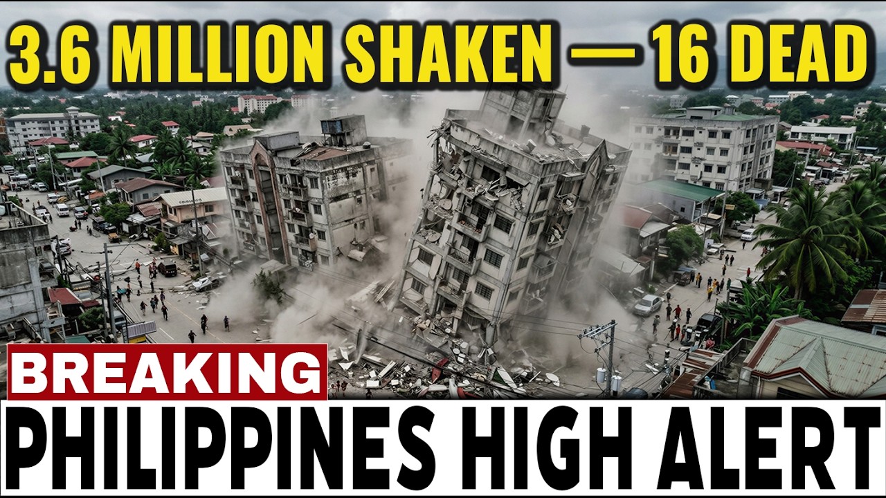
On the morning of June 8, 2026, at 7:37:41 a.m. local time, a magnitude 7.8 earthquake struck offshore southern Mindanao, with its epicenter approximately 32 km south of Maasim, Sarangani — about 13 km southwest of General Santos City. The Philippine Institute of Volcanology and Seismology (PHIVOLCS) initially recorded the quake at magnitude 7.0 before revising it to 7.8 within hours. The depth was approximately 33 km. The source was identified as the Cotabato Trench, the same fault structure responsible for the 1976 Moro Gulf earthquake. This was the strongest earthquake to hit the Philippines in 36 years — the most powerful since 1990. PHIVOLCS recorded Intensity VII (destructive) in General Santos City and instrumental Intensity VIII in Malapatan, Sarangani. According to GDACS, approximately 3.6 million people were exposed to ground motion of MMI VII or greater. Early reports counted at least 16 people dead and more than 200 injured, with damaged buildings, partial collapses, and a key bridge flagged with structural cracks across General Santos. The international airport in General Santos was temporarily closed and 17 domestic flights were canceled. In Davao del Sur, an abandoned building at Matanao National High School collapsed during the morning flag-raising ceremony — all students and teachers were already outside and there were no injuries at the Matanao incident. The earthquake also triggered real tsunami waves — not just a theoretical warning. PHIVOLCS-monitored tide gauges recorded waves of approximately 1 meter in Sultan Kudarat and Sarangani provinces, with a measurement of 1.4 meters along the coastal area of Kiamba in Sarangani. An 83-centimeter wave reached Sulawesi, Indonesia, while smaller signals were recorded in Taiwan, Palau, southern Japan, and Papua New Guinea. PHIVOLCS issued a tsunami warning and ordered immediate evacuations from coastal areas in nine provinces: Sarangani, Davao Occidental, Tawi-Tawi, Sulu, Basilan, Zamboanga del Sur, Zamboanga Sibugay, Sultan Kudarat, and South Cotabato. The Pacific Tsunami Warning Center issued advisories for the Philippines, Indonesia, Palau, Taiwan, Japan, and Papua New Guinea, before lifting the immediate threat approximately five hours after the earthquake. President Ferdinand Marcos Jr. addressed the nation and told coastal residents to move to higher ground without waiting, assuring that disaster-response agencies were on standby. The Department of Health activated its crisis protocol. Within hours of the earthquake, the chief of the PHIVOLCS Seismology Division, Winchelle Ian Sevilla, identified the source on national media: "This is the structure responsible for the 1976 Moro Gulf earthquake and tsunami." On August 17, 1976, the same Cotabato Trench ruptured with magnitude 8.1, producing a predawn tsunami that swept the Moro Gulf coast and killed approximately 8,000 people — the deadliest natural disaster in modern Philippine history. Mindanao lies at a complex convergent boundary where the Sunda plate and the Philippine Sea plate meet, with subduction along the Cotabato Trench and strike-slip motion accommodated by the Cotabato Fault System and Philippine Fault Zone. PHIVOLCS has warned of continuing aftershocks above magnitude 6 in the coming hours and days, and has cautioned residents not to re-enter damaged buildings because aftershocks can bring down weakened structures. The Pacific Tsunami Warning Center has lifted the immediate tsunami threat, but PHIVOLCS has not declared the seismic sequence finished. The central editorial question is not whether the Cotabato Trench can produce a deadly tsunami — it did so in 1976, and the historical death toll is the proof — but whether the next 24 to 72 hours of aftershocks along southern Mindanao reveal that this morning was the whole story, or only the beginning of a sequence the southern Philippines has not seen in half a century.
Fair Use Disclaimer: This video may include copyrighted material used for criticism, comment, news reporting, teaching, scholarship, and research, in accordance with Section 107 of the U.S. Copyright Act. All footage and images remain the property of their respective owners. If you are a rights holder, please contact [email protected].
Contact: [email protected]
#crisisradar #brokenearth #philippines #mindanao #earthquake #m78 #tsunami #sarangani #generalsantos #phivolcs #cotabatotrench #morogulf #pacificringoffire #breakingnews #seismology
Повторяем попытку...
Доступные форматы для скачивания:
Скачать видео
-
Информация по загрузке: