⁴ᴷ⁶⁰ Walking Philadelphia: Benjamin Franklin Parkway from Philadelphia Museum of Art to City Hall
Автор: Walking & Driving Incognito
Загружено: 2025-02-26
Просмотров: 161
Описание:
February 17, 2025 - 12:20 PM
37°F / 3°C
Walking (without narration) eastbound on the entire length of Benjamin Franklin parkway in Philadelphia, Pennsylvania, from the Philadelphia Museum of Art to City Hall. Filmed with GoPro Hero 12. (This video was filmed one week after the Philadelphia Eagles won Super Bowl LIX and a few days after the city's Super Bowl victory parade; there was an anti-DOGE protest march ongoing on the Parkway during this video's filming)
Highlights:
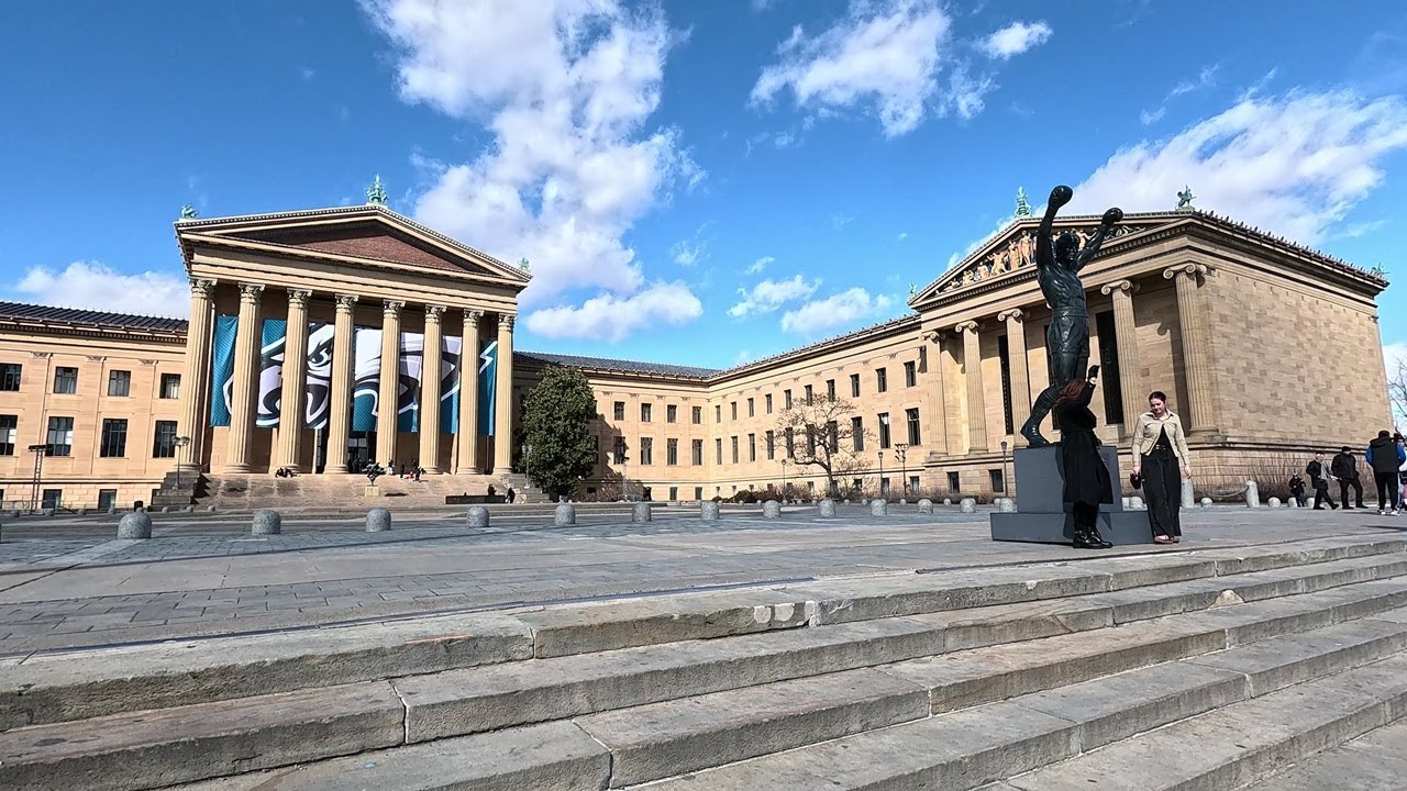
00:00 - The Philadelphia Museum of Art
04:42 - Parkway Visitor Center and the Rocky Shop
07:20 - Washington Monument Fountain, Eakins Oval
14:16 - The Rodin Museum
16:51 - The Barnes Foundation
18:20 - Civil War Soldiers and Sailors Memorial
19:49 - The Franklin Institute, Logan Square
20:53 - Shakespeare Memorial, Parkway Central Library
22:48 - General Galusha Pennypacker Memorial
23:23 - Sister Cities Park, Cathedral Basilica of Saints Peter and Paul
24:42 - Anti-DOGE protest march
28:06 - Cret Park
31:31 - LOVE Park (also known as John F. Kennedy Plaza)
34:57 - Dilworth Park, 15th Street-City Hall SEPTA subway station
36:28 - Philadelphia City Hall
From Wikipedia:
"Benjamin Franklin Parkway, commonly abbreviated to Ben Franklin Parkway and colloquially called the Parkway, is a boulevard that runs through the cultural heart of Philadelphia, the nation's sixth-largest city as of 2020.
The parkway is named for Benjamin Franklin, a Founding Father greatly affiliated with the city and the successful American Revolution, which led to American independence.
The mile-long parkway cuts diagonally across the grid plan pattern of Center City's northwest quadrant, starting at Philadelphia City Hall, curving around Logan Circle, and ending before the Philadelphia Museum of Art.
In a city famous for its urban planning, the Parkway represents one of the earliest examples of urban renewal in the United States. The road was constructed to ease heavy industrial congestion in Center City and to restore Philadelphia's natural and artistic beauty, as part of the City Beautiful movement.
The vision for a grand parkway came from retail pioneer John Wanamaker. Preliminary proposals for the Parkway had been produced and added to the City Plan by 1906, but the first comprehensive plan for the Parkway was commissioned in 1907 by the Fairmount Park Art Association, now the Association for Public Art. The Association commissioned architects Horace Trumbauer, Clarence Zantzinger, and Paul Philippe Cret, who created a detailed parkway design that was formally added to the City Plan in 1909. Construction on the Parkway did not begin until 1917, when French landscape architect Jacques Gréber submitted a revised plan to the Commissioners of Fairmount Park.
Gréber designed the Parkway in 1917 to emulate the Champs-Élysées in Paris, France. The route was determined by an axis drawn from Philadelphia City Hall to a fixed point on the hill that William Penn called "Fairmount", now the site of the Philadelphia Museum of Art. The Champs-Élysées terminates at the Arc de Triomphe, and the Parkway's terminating at the Art Museum gives the notion of "a slice of Paris in Philadelphia." The Parkway contains flags of countries from around the world.
The traffic rotary on the western end of the Parkway, at the foot of the Art Museum's Rocky Steps, is named Eakins Oval after Philadelphia painter Thomas Eakins. The traffic lanes around Eakins Oval originally formed a regular oval; this pattern was modified in the early 1960s to its present elongated circular shape, with the truncated lanes serving as staging areas for various events.
On September 26 and 27, 2015, Pope Francis visited Philadelphia for that year's World Meeting of Families; the Parkway was flooded with over a million visitors both weekend days, a Celebration of Families on Saturday, and a Holy Mass on Sunday.
There has been concern that the original plan of a wide, multi-sectioned, multi-lane, tree-lined boulevard, while beautiful to travel on, is not very engaging for pedestrian or other public use. Traffic along the Parkway has decreased considerably because of the completion of Interstate 676 (Vine Street Expressway), linking the Schuylkill Expressway with the Benjamin Franklin Bridge. The roadway was since narrowed somewhat and the sidewalks expanded around Logan Circle. A plan for a greener, more walkable Parkway was released by the city in 2023."
Повторяем попытку...
Доступные форматы для скачивания:
Скачать видео
-
Информация по загрузке:
![Following in the footsteps of Rocky!! 🥊 Philadelphia Walking Tour of Benjamin Franklin Parkway [4K]](https://image.4k-video.ru/id-video/CZLL1l1HauA)


![A Day in Philadelphia 1920s in color [60fps,Remastered] w/sound design added](https://image.4k-video.ru/id-video/xXdNvIBeUZY)


![Downtown Philadelphia, Pennsylvania | Walking Tour 2025 [4K]](https://image.4k-video.ru/id-video/93V6Lh91AHo)


