Ferrari Horse 🐎 🦄 Unicorn Trail - Penang Hiking vlog
Автор: Martin Tang
Загружено: 2022-03-01
Просмотров: 2807
Описание:
Wish to make your hiking trail become a horse or unicorn shape?
We made it and the journey is really long but satisfying.
👣 Here is the GPX file: https://drive.google.com/file/d/1nY3o...
Thanks to the power of Facebook group sharing and social media, we were able to contact the hiker who conquered this Ferrari Kuda Trail before in Penang.
Besides, the hiker even recorded the GPX hiking record, so basically, we obtain the most accurate map and direction.
A good journey needs to start with good planning. One of our members in the team research the GPX record and check all the routes to double confirm the direction.
Glad he put his efforts to think about the difficulty, attitude and distance for our version of Ferrari Kuda Trail. In short, if we start to another way around/reverse, I don't think we can finish. 😅
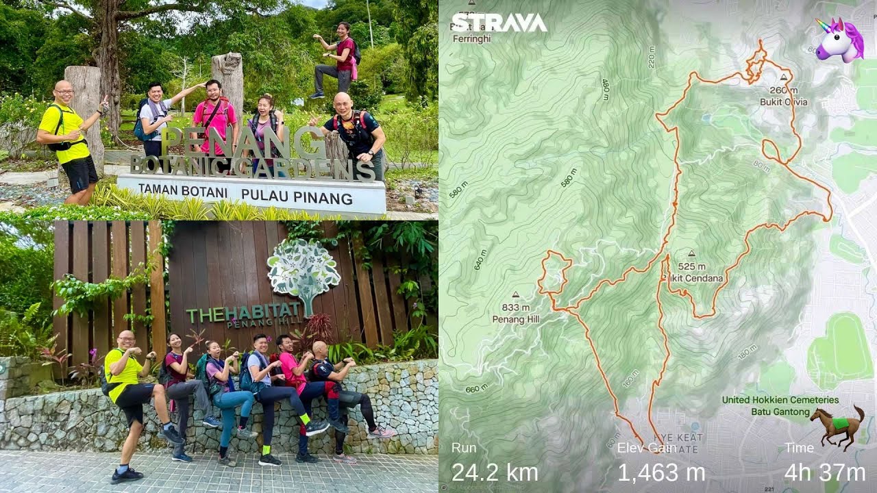
You might notice why the video title add the Unicorn Trail? This is because we're walking to the wrong route and adding a horn to the 'horse'. Luckily the line still makes sense and does not spoil the overall shape of the horse.
By the time we have reached the Botanical Garden, we can feel the legs already exhausted. But still need to continue to plot the complete trail of the horse/unicorn we aim for.
The journey confirms the need for multiple breaks in between for food replenish. We choose Station 5 as our location for a longer lunch break.
Anyway, if you're fit enough, usually they say not recommended to stop too long as the body needs to restart the journey is even tiring. However, if you need a rest, please just have a break at any time and slow down the pace at a reasonable speed.
The last journey using the Hye Keat Hiking Trail is another challenge downhill. My feet and ankle already can feel the pain during that moment.
Finally, we walked to the starting point at the parking space we parked and stop tracking to complete the shape of the Ferrari house and in our case become a unicorn.
Initially, I thought 3L of water is sufficient for me but it's not. Luckily we have extra water among our members to refill during the journey. I guess this kind of long journey might need 4L of water for me.
You might wonder how we can plot the hiking trail? The answer is using the GAIA app (https://www.gaiagps.com). To cut short, it's like the Google Map for hiking. I highly recommended downloading, checking and enabling this app during hiking.
When you reach a junction, just open the app and check the direction to choose the right path. On top of that, you also can record your own hiking trail and export it into a GPX file. Then can share with anyone.
The funny stories are when we stop the tracking and check the shape of our horses using our tracking app, the results vary in terms of total distances. Some are longer or shorter but I can confirm it will be more than 20km.
If you are able to gather a few buddies that want to explore the creativity of hiking, plotting into a shape is a good idea and fun.
⚠️ A piece of advice for the public: This trail is not suitable for beginners. Although you'll not uphill or climb much (in terms of the total distance), the long journey will slowly make your feet suffer.
👟 Relive video: https://www.relive.cc/view/vMq5E1A4e8q
⏱️ Duration: 8 hrs+
📏 Distance: 22.3km
=====================
📷 Camera: Panasonic Lumix GH5
Lens: Panasonic Lumix Leica 8-18mm F2.8-4.0, Olympus M.Zuiko Digital ED 40-150mm f/4-5.6 R
Profile: VLog-L
LUT: FilmConvert Nitrate
#penanghill #ferrarikudatrail #unicorntrail
Повторяем попытку...
Доступные форматы для скачивания:
Скачать видео
-
Информация по загрузке:


