How Satellites See Forests, Water & Minerals from Space | Remote Sensing Explained 🚀🌍
Автор: Quick News
Загружено: 2026-01-06
Просмотров: 231
Описание:
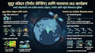
Satellites can see forests breathe, water hide underground, and minerals buried deep below Earth’s surface — all without touching the ground 🌍🛰️
In this video, we explain remote sensing technology in simple language — how satellites and drones use visible light, infrared, radar, gravity, and magnetic fields to map:
✅ Forest health & plant growth (NDVI)
✅ Rivers, lakes & floods (NDWI & SAR)
✅ Groundwater depletion (GRACE satellites)
✅ Oil, gas & mineral deposits (hyperspectral imaging)
✅ Climate change & carbon storage
From Indian groundwater crisis to space-based mineral exploration, this video breaks down how modern satellites help scientists, farmers, environmentalists, and governments make smarter decisions.
📌 Based on a detailed science explainer by The Hindu
📌 Perfect for UPSC, SSC, State PSC, students & space enthusiasts
🔔 Like, Share & Subscribe for more Science + Space explainers
💬 Comment if you want a Hindi version or UPSC-focused notes
remote sensing explained
satellite remote sensing
how satellites see earth
forest monitoring from space
groundwater detection satellite
NDVI NDWI explained
hyperspectral imaging minerals
SAR satellite flood mapping
GRACE satellite groundwater
ISRO remote sensing
space technology India
earth observation satellites
satellite mapping resources
#RemoteSensing
#SatelliteTechnology
#SpaceScience
#EarthObservation
#ISRO
#ScienceExplained
#ClimateChange
#GroundwaterCrisis
#ForestMonitoring
#Hyperspectral
#SAR
#IndianScience
remote sensing
remote sensing technology
satellite science
how satellites work
forest health satellite
water detection from space
groundwater satellite
oil and gas exploration satellite
mineral mapping satellite
NDVI explained
NDWI explained
SAR satellite
GRACE mission
ISRO satellites
space tech India
earth science
Повторяем попытку...

Доступные форматы для скачивания:
Скачать видео
-
Информация по загрузке: