ycliper

Популярное

Музыка Кино и Анимация Автомобили Животные Спорт Путешествия Игры Юмор

Интересные видео

2025 Сериалы Трейлеры Новости Как сделать Видеоуроки Diy своими руками

Топ запросов

смотреть а4 schoolboy runaway турецкий сериал смотреть мультфильмы эдисон
Скачать

Masking and Classify clouds in satellite imagery using fmask

Автор: GEO 2004

Загружено: 2018-11-07

Просмотров: 12118

Описание: 
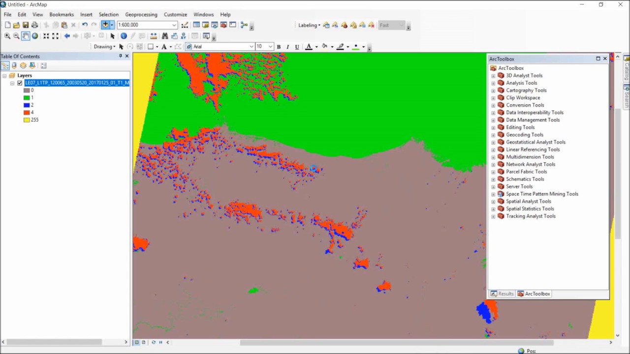
How to mask clouds, shadow, water body, and snow from Landsat series Satellite Imagery automatically using Fmask software.

clouds masking followed by clouds removing are important steps if you want to get cloud-free imagery for your analysis needs.

about how to make cloud-free imagery, check this tutorial :    • removing clouds from aerial photographs/sa...  

if you curious about how to perform similar task using Sentinel-2 Imagery , check this out :    • Automatic cloud Masking of Sentinel 2 Imag...  

music by : www.bensound.com

Не удается загрузить Youtube-плеер. Проверьте блокировку Youtube в вашей сети.
Повторяем попытку...
Masking and Classify clouds in satellite imagery using fmask

Поделиться в:

Доступные форматы для скачивания:

Скачать видео

  • Информация по загрузке:

Скачать аудио

Похожие видео

How to Remove Clouds from Satellite Images using QGIS

How to Remove Clouds from Satellite Images using QGIS

Landsat NDVI time-series in Google Earth Engine

Landsat NDVI time-series in Google Earth Engine

Tutorial on How to Use a CPU to Extract Detailed Road Networks Directly from Satellite Imagery

Tutorial on How to Use a CPU to Extract Detailed Road Networks Directly from Satellite Imagery

Geog136 Lecture 11.1 Remote sensing basics

Geog136 Lecture 11.1 Remote sensing basics

Satellite Imagery Clouds Cover Removal in ArcGIS Desktop

Satellite Imagery Clouds Cover Removal in ArcGIS Desktop

System Design Concepts Course and Interview Prep

System Design Concepts Course and Interview Prep

How to remove cloud and cloud shadow from Satellite images using ArcGIS/Pro

How to remove cloud and cloud shadow from Satellite images using ArcGIS/Pro

But what is quantum computing?  (Grover's Algorithm)

But what is quantum computing? (Grover's Algorithm)

Арестович: Антиевропейский демарш Зеленского? Дневник войны

Арестович: Антиевропейский демарш Зеленского? Дневник войны

Никакого газа, никаких дров 😱!! Эта простая самодельная печь отапливает дом БЕСПЛАТНО всю зиму

Никакого газа, никаких дров 😱!! Эта простая самодельная печь отапливает дом БЕСПЛАТНО всю зиму

$12 Миллиардов, Но Бесплатно Для Всех. Что Скрывает GPS?

$12 Миллиардов, Но Бесплатно Для Всех. Что Скрывает GPS?

Exploring Sentinel-2 multi-spectral band combinations in SNAP

Exploring Sentinel-2 multi-spectral band combinations in SNAP

228 - Semantic segmentation of aerial (satellite) imagery using U-net

228 - Semantic segmentation of aerial (satellite) imagery using U-net

Cloud Masking of Landsat images in the Envi Software (Cloud Removal)

Cloud Masking of Landsat images in the Envi Software (Cloud Removal)

Договор о гарантиях США для Украины— это защита или ловушка? /№1085/ Юрий Швец

Договор о гарантиях США для Украины— это защита или ловушка? /№1085/ Юрий Швец

Understanding VSWR and Return Loss

Understanding VSWR and Return Loss

РЫСЬ В ДЕЛЕ... Рысь против волка, койота, змеи, оленя!

РЫСЬ В ДЕЛЕ... Рысь против волка, койота, змеи, оленя!

Подготовка к удару? Американская армада движется на Иран

Подготовка к удару? Американская армада движется на Иран

«Бесплатные деньги» ежемесячно? Почему не вводят безусловный базовый доход

«Бесплатные деньги» ежемесячно? Почему не вводят безусловный базовый доход

Motor Basics

Motor Basics

© 2025 ycliper. Все права защищены.


  • Контакты
  • О нас
  • Политика конфиденциальности


Контакты для правообладателей: [email protected]