ycliper

Популярное

Музыка Кино и Анимация Автомобили Животные Спорт Путешествия Игры Юмор

Интересные видео

2025 Сериалы Трейлеры Новости Как сделать Видеоуроки Diy своими руками

Топ запросов

смотреть а4 schoolboy runaway турецкий сериал смотреть мультфильмы эдисон
Скачать

Exploratory Analysis – Viewshed Tool Basics

Автор: ArcGIS

Загружено: 2020-11-16

Просмотров: 5212

Описание: This lesson explains how to use the Viewshed Exploratory Analysis tool to quickly determine outward visibility from a known location using ArcGIS Pro.

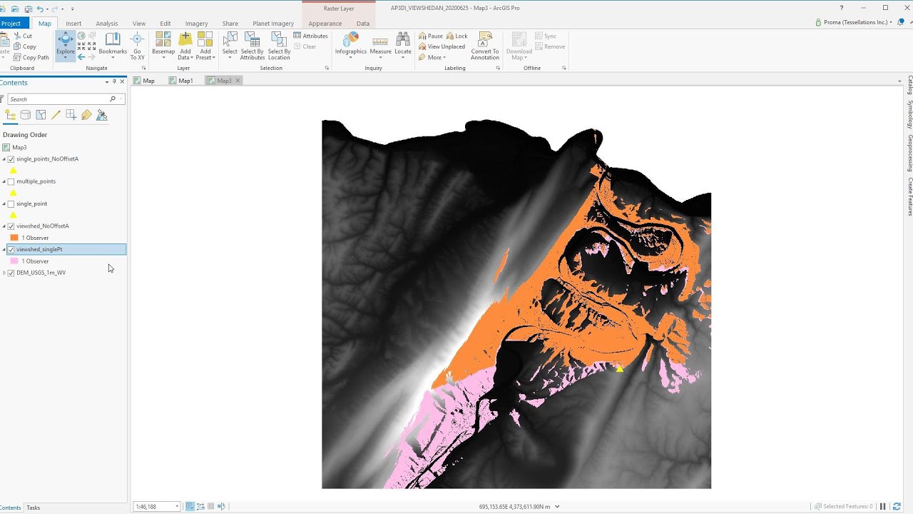
Interactive viewsheds are used to determine the visible areas of a 3D view from a given viewpoint. For example, you might need to place security cameras to monitor a park, film cameras throughout a sporting event, or police officers around a political rally. In all these cases, you want to optimize their locations to avoid missed coverage and reduce areas with double coverage.

In our example, we’ll be determining visibility from ground level within an empty lot and at a neighboring mid-street crossing. The viewshed will reflect green for anything that can be seen from the observer point, magenta for anything it cannot see, or yellow for anything that is seen by more than one viewshed.

In this short video, you will learn how to:
• Interactively place one or more viewshed observers
• Resize, rotate, and reposition a viewshed using its interactive handles
• Use the C key to quickly navigate without changing active tools

After watching this lesson, you might be interested in other lessons in the series that cover other Exploratory Analysis tools in more detail.

For more information, please visit: http://ow.ly/ogfl50CmlE1

---------------------------------------------------------------------------------------------------
Follow us on Social Media!
Twitter:   / esri  
Facebook:   / esrigis  
LinkedIn:   / esri  
Instagram:   / esrigram  

The Science of Where: http://www.esri.com

Не удается загрузить Youtube-плеер. Проверьте блокировку Youtube в вашей сети.
Повторяем попытку...
Exploratory Analysis – Viewshed Tool Basics

Поделиться в:

Доступные форматы для скачивания:

Скачать видео

  • Информация по загрузке:

Скачать аудио

Похожие видео

Исследовательский анализ – Основы инструмента профиля рельефа

Исследовательский анализ – Основы инструмента профиля рельефа

Performing a visibility analysis in ArcGIS Pro

Performing a visibility analysis in ArcGIS Pro

Viewshed analysis in QGIS 3 | visibility analysis | part-1

Viewshed analysis in QGIS 3 | visibility analysis | part-1

Point Clouds - 30 min BricsCAD In Depth Session

Point Clouds - 30 min BricsCAD In Depth Session

Как создать области видимости в ArcGIS Pro

Как создать области видимости в ArcGIS Pro

How to Perform Service Area and Location-Allocation Analysis in ArcGIS Pro?

How to Perform Service Area and Location-Allocation Analysis in ArcGIS Pro?

Наиболее эффективные способы использования Google Earth Pro с Nano Banana AI в Google AI Studio f...

Наиболее эффективные способы использования Google Earth Pro с Nano Banana AI в Google AI Studio f...

ArcGIS Pro: Viewshed, Observer Points and Visibility

ArcGIS Pro: Viewshed, Observer Points and Visibility

Deep House Mix 2024 | Deep House, Vocal House, Nu Disco, Chillout Mix by Diamond #3

Deep House Mix 2024 | Deep House, Vocal House, Nu Disco, Chillout Mix by Diamond #3

Select by Location ArcGIS Pro. Spatial Analysis ArcGIS Pro.

Select by Location ArcGIS Pro. Spatial Analysis ArcGIS Pro.

3D-визуализации в ArcGIS Pro

3D-визуализации в ArcGIS Pro

SHAZAM Top 50🏖️Лучшая Музыка 2025🏖️Зарубежные песни Хиты🏖️Популярные Песни Слушать Бесплатно #40

SHAZAM Top 50🏖️Лучшая Музыка 2025🏖️Зарубежные песни Хиты🏖️Популярные Песни Слушать Бесплатно #40

Abstract Black and White wave pattern| Height Map Footage| 3 hours Topographic 4k  Background

Abstract Black and White wave pattern| Height Map Footage| 3 hours Topographic 4k Background

$12 Миллиардов, Но Бесплатно Для Всех. Что Скрывает GPS?

$12 Миллиардов, Но Бесплатно Для Всех. Что Скрывает GPS?

Сисадмины больше не нужны? Gemini настраивает Linux сервер и устанавливает cтек N8N. ЭТО ЗАКОННО?

Сисадмины больше не нужны? Gemini настраивает Linux сервер и устанавливает cтек N8N. ЭТО ЗАКОННО?

Animate Your Maps with ArcGIS Pro

Animate Your Maps with ArcGIS Pro

Security Camera Visibility Analysis in ArcGIS Pro

Security Camera Visibility Analysis in ArcGIS Pro

3D Visualization of a DEM in ArcGIS Pro

3D Visualization of a DEM in ArcGIS Pro

Vector Geoprocessing in ArcGIS Pro: Buffer & Overlay

Vector Geoprocessing in ArcGIS Pro: Buffer & Overlay

ArcGIS Pro Exploratory Analysis – Line of Sight Tool Basics

ArcGIS Pro Exploratory Analysis – Line of Sight Tool Basics

© 2025 ycliper. Все права защищены.


  • Контакты
  • О нас
  • Политика конфиденциальности


Контакты для правообладателей: [email protected]