MAJOR Winter Storm Update: 18" Snow Forecast | Atlanta, Raleigh, Charlotte
Автор: NEDD
Загружено: 2026-01-29
Просмотров: 438
Описание:
🌨️ CRITICAL WEATHER UPDATE: The most significant winter storm in over a decade is targeting the Southeast and East Coast with potentially historic snowfall totals. Arctic air from the polar circle is colliding with a developing coastal storm system that could undergo bombogenesis, bringing 18+ inches of snow to multiple major cities and paralyzing travel across the Eastern United States.
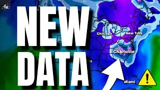
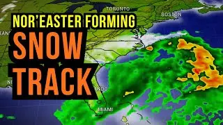
EXACT TIMING BY CITY: Knoxville TN - Friday 4 PM start, 7-12" expected. Nashville - Friday 8 PM, heavy overnight, 5-9" metro area. Atlanta - Saturday 4 AM start, 4-8" downtown, 6-10" northern suburbs including Marietta, Roswell, Alpharetta. Augusta GA - Saturday 6 AM, potential bullseye with 8-13", most since 2014. Columbia SC - Saturday 7 AM, historic 12-18" possible. Charlotte NC - Saturday 9 AM, 10-15" expected. Raleigh NC - Saturday noon, heavy by 3 PM, 10-16" forecast. Virginia Beach - Saturday 10 PM start. Richmond VA - Sunday 6 AM. Washington DC - Sunday 10 AM, 6-11" expected. Philadelphia - Sunday noon. Boston - Sunday 2 PM. Cape Cod - Sunday afternoon into Monday, catastrophic 14-22" with 85 mph wind gusts. The National Weather Service confirms this low will reach 968mb pressure - Category 2 hurricane equivalent strength. Widespread blizzard warnings and winter storm warnings are in effect from Tennessee to Maine.
DANGEROUS COLD FOLLOWS: Miami dropping to 23°F Sunday morning - citrus freeze damage expected. Tampa hard freeze at 32°F. Atlanta 20°F. Charlotte wind chill 8°F. Raleigh wind chill 12°F. New York City wind chill 5°F. Boston wind chill -5°F. These are life-threatening temperatures for the Southeast. Burst pipe risks extremely high. Protect outdoor plants and pets immediately.
PREPARE NOW - NOT TOMORROW: Grocery stores will be cleared out by Friday evening. Get water, non-perishable food, batteries, flashlights, candles, medications, and pet supplies today. Fill vehicles with gas. Charge backup batteries. Download offline maps. Power outages likely to last multiple days in hardest hit areas due to heavy snow on trees and power lines combined with wind. Do not travel Saturday-Monday unless life-threatening emergency.
🔔 DROP YOUR CITY BELOW for personalized forecast! | SUBSCRIBE + notifications ON | Share with neighbors
#WeatherToday #WeatherForecast #WinterStormWarning #SevereWeatherAlert #EastCoastWeather #AtlantaWeather
Повторяем попытку...

Доступные форматы для скачивания:
Скачать видео
-
Информация по загрузке: