Auden's Col June 2018 - Full Video
Автор: Mayank Pareek
Загружено: 2018-06-28
Просмотров: 5758
Описание:
Auden’s Col is a high altitude mountain pass connecting Rudugaira valley and Bhilangna valley. It is situated at 5,490 metres (18,010 ft) elevation and connects the ridge coming from Gangotri III (6580 m) peak on the north-west and the ridge coming from Jogin I (6465 m) on the east, and also binds a glacier coming from Jogin I on the north side of Rudugaira valley, and deadly Khatling glacier on the south side of Bhilangna valley.
We drove to Gangotri and started trek next morning. Although we did not, I would highly recommend planning for an additional acclimatization day in Gangotri - this would make the life a lot easier in the first few days...
First 2 days were moderate - walk of 5-6 hours and an elevation of about 500-600 m each day with some steep patches. The trail was mostly marked and the route was through forest and meadow. We reached Rudugaria camp at an elevation of ~4.5k - beautiful campsite with the first view of snow covered Jogin and Gangotri peaks.
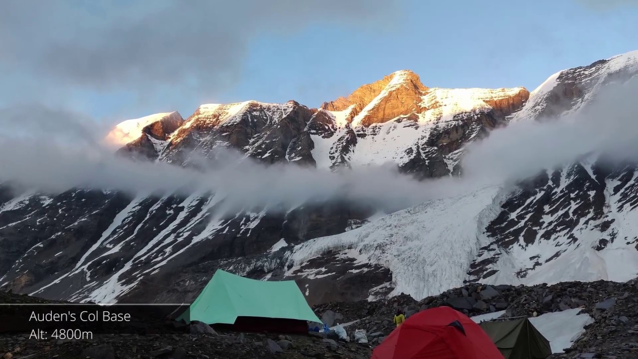
We spend next day acclimatizing, which was much needed before moving ahead. Day 4, we moved to Auden's col base camp at 4.9k after a walk through boulders and some steep parts.
The next day was the D day - we started early, took us ~6 hours after a very tiring walk to reach the top. The weather was good but the soft snow made it difficult to walk. Crossing the other side of the col was a task - the descent was very steep and we had to use fixed ropes. A couple of hour walk after the descent, we setup the camp on the Khatling glacier.
The aim for the next day was crossing Khatling Glacier - after some walk on the hard snow, it was walk in the moraine - slippery black ice and rocks. The route was not marked at all (we were probably the first group to cross this season). This is where it's a must to have experienced guides. It took us strenuous 12 hours to reach the zero point.
One of our team members had gotten sick (it's not tough to catch mountain sickness) on the pass day and crossed the Khatling Glacier with great difficulty (reaching campsite post-midnight). We decided to take a rest day at zero point.
Next day was a level walk alongside the river Bhilangana to Chowki. We were now back in the pleasant vegetation zone. Just before Chowki, there is a makeshift bridge to cross the river. The bridge was not in the best conditions and was too risky to cross (we even thought of setting up a safety rope, but turned out it wasn't feasible). The river could have been crossed at the start of the day where the flow was low, but we had already walked 5 hours post that point. So, with no other option, we decided to skip the Mayali pass and continue the descent through Gutthu route.
It took us 2 more long (8-9 hour walk each day) but beautiful to reach the first village in Bilangana valley - Gangi. From Gangi, we descended to a place called Reh and from there we drove to Gutthu and further to Ghansali (which is a fairly big town with hotels and bus connectivity to Rishikesh). There is a road that's being constructed from Gutthu to Gangi (expected date of completion is in 2020) post which I believe vehicles can be arranged in Gangi.
Auden's col is not easy by any means - it's long, it's high and it's remote. And there is some objective danger after crossing the pass on the Khatling Glacier.
Повторяем попытку...
Доступные форматы для скачивания:
Скачать видео
-
Информация по загрузке: