360 Acres of Urban Breaklines — Tuscan Village Point Cloud Fly-Through (ROCK Ultra Drone LiDAR)
Автор: ROCK Robotic
Загружено: 2025-12-23
Просмотров: 121
Описание:
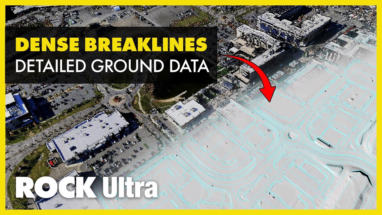
360 acres. Complex urban breaklines. Captured in ~45 minutes.
Experience a dataset fly-through of Tuscan Village (Salem, NH) — a multi-phase urban redevelopment captured by Chris Stein (Senior Survey Technician, GPI) using the ROCK Ultra.
This visualization showcases the actual processed dataset from the project, rendered through multiple views (RGB, elevation, classification, and breakline/surface outputs). You’ll see curb networks, hardscape transitions, and dense edge detail—the features that define engineering-grade surface models.
In this project, the ROCK Ultra captured the full site at 380 ft AGL (≈115 m) and 10 m/s, covering 360 acres with speed, stability, and detail. The workflow continues beyond capture: the dataset supports rapid classification, surface modeling, and breaklines at scale through ROCK Pro Services—even through the holiday turnaround window.
“I think you guys have done an awesome job at this. This is a very complex data set. It's done well.” ⭐⭐⭐⭐⭐ — Chris Stein, Senior Survey Technician, GPI
📊 Dataset Highlights
→ Collected By: GPI (Chris Stein, Senior Survey Technician)
→ Job Site: Tuscan Village Urban Redevelopment, Salem, NH
→ Total Area: 360 acres (multi-phase development site)
→ Flight Height: 380 ft AGL (≈115 m)
→ Flight Speed: 10 m/s
→ Dataset Features:
✓ Dense breaklines + curb detail across complex urban surfaces
✓ Highly accurate surface model tied to ground control
✓ Classified point cloud with ground, vegetation, and building layers
🔎 Explore the dataset + read the case study:
https://www.rockrobotic.com/articles/...
🎥 Watch the full-length discussion on YouTube:
• How a Surveyor Mapped a Huge Urban Redevel...
ℹ️ Learn more about ROCK Ultra:
https://www.rockrobotic.com/hardware/...
💬 Talk to a ROCK LiDAR expert:
https://www.rockrobotic.com/talk-to-s...
#ROCKUltra #ROCKRobotic #DroneLiDAR #AerialLiDAR #LiDAR #Surveying #LandSurveying #Geomatics #Geospatial #RealityCapture #PointCloud #PointCloudProcessing #DTM #DEM #Breaklines #SurfaceModeling #CivilEngineering #Construction #ConstructionTechnology #UrbanDevelopment #DroneMapping #UAV #ROCKCloud #ROCKProServices #ROCKUltraDemoTour
Повторяем попытку...
Доступные форматы для скачивания:
Скачать видео
-
Информация по загрузке: