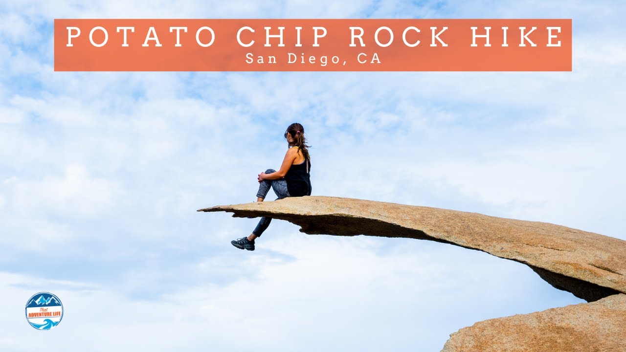
Potato Chip Rock via HWY 67 | Trail Recap | Ramonca, CA | 4K
Автор: Daniel Kusper
Загружено: 2023-05-09
Просмотров: 2006
Описание:
Woodson Mountain and Potato Chip Rock via Hwy 67 is a 4.24-mile trail with 1,230 feet of elevation gain and is located in Ramona, California. This quick way to get to Potato Chip Rock involves mostly hiking up a fire road.
#potatochiprock #potatochiptrail #mtwoodson #hikereview #hikesandiego
Virtual / Extended Cut Video: • Potato Chip Rock via HWY 67 | Full Hike | ...
Blog Post: Coming Soon
==== My Gear & Support The Channel ====
Disclosure: Some of the links below are affiliate links, meaning, at no additional cost to you, I will earn a commission if you click through and make a purchase.
Buy anything from Amazon: https://amzn.to/3ymIprx
** Activity Tracking **
Garmin InReach: https://amzn.to/2SUFk1s
Garmin InReach Screen Protector: https://amzn.to/3v6GxBg
Garmin Instinct Watch : https://amzn.to/3yxo3vV
Garmin Instinct Watch Band: https://amzn.to/3ftpCSN
** Main Trail Camera Setup **
GoPro Hero7 Black: https://amzn.to/2T53zu4
GoPro Karma Grip x2: https://amzn.to/3wlDK7w
ND Filters (helps cut harsh light & improve video quality): https://amzn.to/3osPqCA
MicroSD: https://amzn.to/2ScUCP2
Chest Mount for Biking: https://amzn.to/3cLOkwX
Extension Cable for Biking: https://amzn.to/3zFoSTU
** Iphone Vlogging **
Iphone 12 Pro Max 256GB: https://amzn.to/2Ty4ByT
Iphone Stand: https://amzn.to/3wu9PKt
Iphone Tripod Mount: https://amzn.to/3ww5sij
Video Micro: https://amzn.to/3wGZrPC
** Studio Setup **
Main Camera (EOS R): https://amzn.to/3zuZQ9S
RF 15-35mm (lens): https://amzn.to/3vu8Rg3
Zoom H6 (audio): https://amzn.to/3pZUak0
Sennheiser MKE600 (mic): https://amzn.to/3gyI0eR
** Hiking Gear **
Water Bladder: https://amzn.to/3cKu9zC
Trecking Poles: https://amzn.to/3cKu9zC
Headlamp: https://amzn.to/2TB0j9S
Flashlight: https://amzn.to/3pXVLqd
First Aid Kit: https://amzn.to/3gC4TfZ
Knife: https://amzn.to/3q4Yq1t
Sunscreen: https://amzn.to/3iLbA1S
Paracord: https://amzn.to/35pdTzZ
Hiking Backpack: https://amzn.to/3xsAreW
** Connect with Me **
AllTrails: https://bit.ly/39ez9um
Instagram: https://bit.ly/2P7k8Un
Facebook: https://bit.ly/3soa1Jc
Twitter: https://bit.ly/3fqFCGT
Newsletter Signup: https://bit.ly/2Pt3pLj
Please Note: The Map Overlay, GPS Coordinates, Elevation Change are all custom coded and synced to the video. These values are approximations. I do my best to make them as accurate as possible, and hope to make it better overtime. You may notice some obvious mistakes, it happens... I hope you enjoy, it took A LOT of time to make with the help of several friends! :)
This is presented for informational use only. Please make sure to do your own research before attempting this adventure. While I try to present this information as accurate as possible, I may have missed important details (comment below if that is the case to help others out). I make no warranties on this information as the adventure details could change without notice.
Make sure to drop a comment below and let me know what trail you want to see next!
Повторяем попытку...

Доступные форматы для скачивания:
Скачать видео
-
Информация по загрузке: