Creating Terrain From Elements | Processing Terrain From Raw Survey Data in OpenRoads
Автор: Civil Soft
Загружено: 2021-10-26
Просмотров: 811
Описание:
★★Skills taught in this video★★
❖Processing Terrain From Raw Survey Data in OpenRoads
◆0:00➜ Intro
◆0:45➜Edit terrain model in openroads
◆10:15➜Report crossing features in openroads
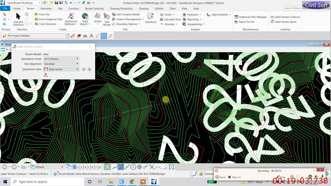
◆18:25➜how to label contours in openroads
◆21:25➜change contour interval openroads
➤ ►Creating Horizontal and Vertical Geometry with Corridor and Cross sections in OpenRoads | Report--- • Creating Horizontal and Vertical Geometry ...
➤ ►What is Feature definition OpenRoads? | create profile in ORD | OpenRoads feature definition library---- • What is Feature definition OpenRoads? | cr...
➤ ►How to take offset from an alignment in OpenRoads with different options | how to draw taper ROW---- • How to take offset from an alignment in Op...
➤ ►Horizontal Geometry Report in OpenRoads | How to generate reports in OpenRoads-- • Horizontal Geometry Report in OpenRoads | ...
➤ ►Creating vertical geometry using openroads designer | design profile | Vertical profile in OpenRoad- • Creating vertical geometry using openroads...
➤ ►Horizontal Geometry Report in OpenRoads | How to generate reports in OpenRoads- • Horizontal Geometry Report in OpenRoads | ...
➤ ►How to add multiple breakline to terrain model in OpenRoads | Break Line feature to a Terrain Model-- • How to add multiple breakline to terrain m...
➤ ►General features of alignment in OpenRoads | Feature definition in openroad designer connectedition-- • General features of alignment in OpenRoads...
➤ ►How to export terrain model to tin format | dgn to tin format |Export Terrain Model to Native Format-- • How to export terrain model to tin format ...
➤ ►importing survey data into Bentley OpenRoad-- • importing survey data into Bentley OpenRoad
➤ ►Introduction to OpenRoad Designer Features | Bentley OpenRoads training videos for beginners-- • Introduction to OpenRoad Designer Features...
➤ ►how to add/create levels in Bentley OpenRoad Designer-- • How to add/create levels in Bentley Open ...
➤ ►Creating and Annotating a Horizontal Alignment | How to create horizontal alignment in OpenRoad-- • Creating and Annotating a Horizontal Align...
➤ ►How do I create a terrain in Openroads ? | Create Terrain from point data | Terrain Model Feature-- • How do I create a terrain in Openroads ? |...
➤ ►how to use fence tool in open road for deleting different element in Bentley openroad microstation-- • How to use fence tool in Openroad for dele...
➤ ►how to add/create levels in Bentley OpenRoad Designer-- • How to add/create levels in Bentley Open ...
➤ ►how to create contours in bentley openroad using survey data | creating contour levels & major/minor-- • how to create contours in bentley openroad...
➤ ►OpenRoads Designer: How to export terrain model to inroad dtm | InRoads (DTM)" vs .dgn - OpenRoads-- • OpenRoads Designer: How to export terrain ...
➤ ►How to export terrain model to tin format | dgn to tin format |Export Terrain Model to Native Format- • How to export terrain model to tin format ...
Повторяем попытку...
Доступные форматы для скачивания:
Скачать видео
-
Информация по загрузке:


![Как сжимаются изображения? [46 МБ ↘↘ 4,07 МБ] JPEG в деталях](https://imager.clipsaver.ru/Kv1Hiv3ox8I/max.jpg)


