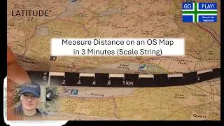
Map Distance vs Real Distance – Why Your Hike Is Longer Than It Looks!
Автор: Latitude 57 official
Загружено: 2025-12-15
Просмотров: 45
Описание:
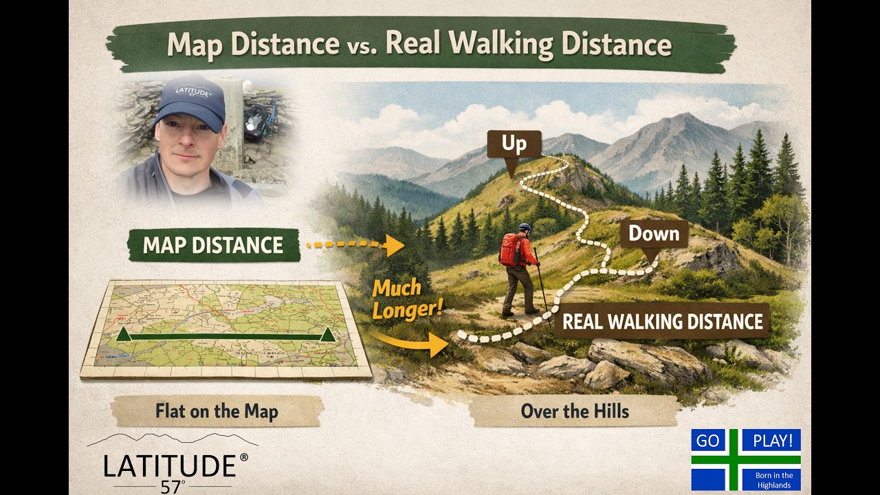
Ever measured a route on a map and wondered why it always feels longer in real life?
In this video, Dale from Latitude 57° demonstrates how to measure distance on Ordnance Survey (OS) maps using string or the edge of a piece of paper — both showing bird’s-eye (map) distance — and then compares it to the real ground distance when height and terrain are added.
You’ll see how:
🗺️ The map shows a straight line across the landscape
🏔️ Real-world hills and obstacles make that same route much longer
📏 Measuring tools on both paper maps and OS Maps Online give a “flat” distance
This simple demonstration clearly shows why the distance you walk is always longer than what the map suggests.
Filmed in the Scottish Highlands by Latitude 57° — inspiring outdoor education, map skills, and adventure for everyone.
⏩ Don’t forget — you can speed up the video! I normally teach real students in front of me and can gauge how well they’re following along, so I take it a bit slower here.
GO PLAY!
#Latitude57 #GoPlay #MapSkills #OSMap #HikingScotland #OutdoorEducation #NavigationTips #ScottishHighlands #MapReading #DistanceMeasurement
👇Share your comments below, as always we will endeavour to answer as many as we can.
0:00 Intro
0:44 Workout💪
1:16 If you don't understand- Ask!⁉️
1:47 What is a map?🗺️
2:41 Measuring distance with a piece of string
4:00 Using the scale bar📏
08:00 Work out the distance measured with the string using the scale bar
12:30 Measuring distance using a piece of paper and pencil
13:45 Using the pencil as a pivot point
17:20 Measuring distance using map case carrying string scale
21:45 Understanding scale and what it actually means
25:00 Easy scale calculation
25:40 Measuring distance using OS mapping software on desktop
28:00 Straw bale demonstration explanation
29:40 Distance demonstration using tape measure and 2D map view
31:00 Real life as opposed to the map
31:30 Distance demonstration using tape measure and simulated mountains
33:00 Outro
33:45 GO PLAY!
🗺️📍🧭- OS Maps- https://osmaps.com/
🗺️ Silva Map Case- https://amzn.eu/d/dvGyX3J
🧭 Map-reading resources available at- https://www.latitude57.co.uk/downloads
🔔Please like and share, be a member of our community of outdoor lovers, help us grow and keep each other safe in the wild.
All of us @ Latitude 57 ° invite you to follow us for additional educational videos and to join us on this journey.
/ @latitude57official
https://www.latitude57.co.uk
/ latitude57official
https://www.facebook.com/profile.php?...
Повторяем попытку...
Доступные форматы для скачивания:
Скачать видео
-
Информация по загрузке: