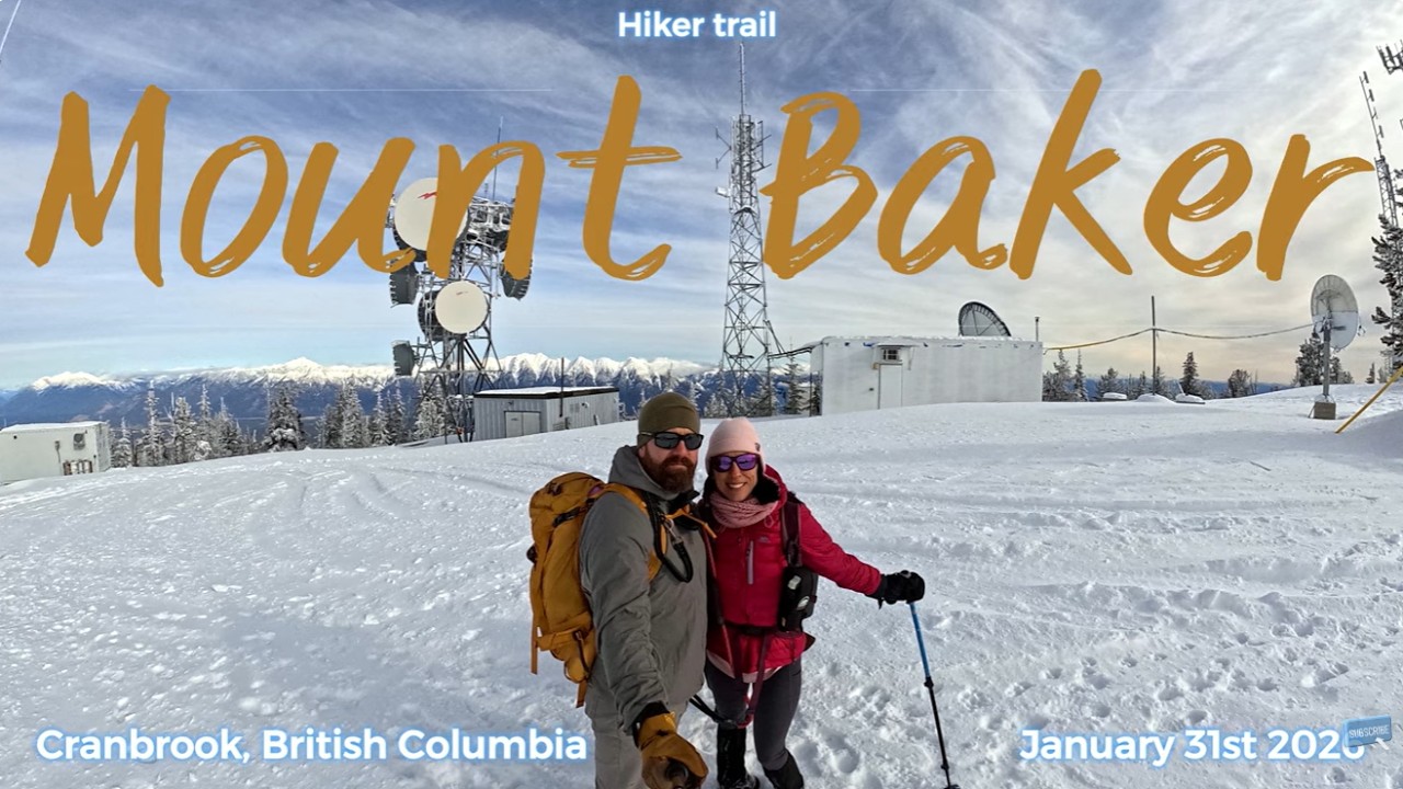
Mount Baker, Cranbrook, BC - January 31st 2026
Автор: Annie Ouellet
Загружено: 2026-02-06
Просмотров: 86
Описание:
Mount Baker - Hiker route
Date : January 31st 2026
Location : Cranbrook, BC
Trailhead location : Off Gold Creek Rd, about 13 min South East of Cranbrook downtown
Distance : 13.9 km
Elevation gain : 1318 m
Time to summit : 3h40 (slow slogging in the deep snow on last 2 km, post holing at its best😑)
Total time to complete including 20 min lunch and hanging out at summit : 6h34
Difficulty: Very hard hike in these conditions, nothing technical, just physical/ no scrambling
Trail traffic : none
Let’s start with the moral of the story: bring your snowshoes… even if the trailhead is completely dry 😩
That said… we’re not originally from Cranbrook. This hike happened during a road trip from Cochrane, AB, to watch our boy play hockey: the Spruce Grove Saints vs the Cranbrook Bucks. And let me tell you… a 4-hour drive was absolutely worth it when the Saints walked away with an 8–2 win 😁
We drove from Cochrane Friday night and winter-camped in Radium to split the trip. Early Saturday morning, we hit the road again and reached the Baker trailhead just before 9 a.m. A late start for us, but unavoidable after all the driving. Add in thick fog slowing us down, because winter loves to keep things unpredictable. The silver lining? Once the fog lifted, we were rewarded with a stunning sunrise along the way.
At the trailhead, everything looked dry and harmless… so we collectively agreed to risk leaving the snowshoes behind.
FAIL.
If you’re 120 lbs like me, you might survive with some post-holing, nothing too crazy. But if you’re a 215-lb athletic husband carrying a heavy pack, that’s a whole different level of suffering. Holy dear crap… it was BAD 😩 Lesson learned (again), even though we should absolutely know better by now. Experienced hikers or not.
The road to the trailhead is fine, but expect muddy conditions right now. We definitely earned a car wash afterward. Parking is available at a small pull-out just before the trailhead. From there, the trail wastes no time, it goes straight up with only a few switchbacks to catch your breath. And yes… it is STEEP.
Blue ribbons and red square markers make route-finding easy. You gain about 1200 m in just a bit under 7 km, with a few downhill sections that you know will be awful on the way back (spoiler: they are). Snow starts appearing as you gain elevation, and it stays fairly packed but slippery and icy until about 2 km from the summit. After that? Deep snow. No snowshoes = you’re screwed.
By the time we reached the summit, my husband, who is in phenomenal shape (military Armor guy, very familiar with hardship), was completely drained. I offered to turn around more than once, but the warrior in him refused. We summited with absolutely zero juice left, knee-deep post-holing on nearly every step.
Our original plan was to descend via the powerline to reach the road faster… until we realized the snow was even worse. Waist-deep post-holing quickly killed that idea, so we backtracked the way we came. Going down is usually easier, but the post-holing still was at its best 😩 lol.
Views along the trail are limited, but when they open up, they’re beautiful. Seeing Cranbrook from above was pretty cool, along with views of the surrounding mountain ranges. The summit itself is interesting, with several towers and an old fire lookout that’s in very rough shape. Access is officially prohibited… the door was open, so I took a quick peek inside, and yeah… it’s not in good condition.
On the way down, even though my husband’s spirit was at an all-time low, we still managed a good chuckle when he reminded me of Bernie from Weekend at Bernie’s…. dead walking his way down the mountain 😂😂😂
All in all, it was quite the adventure. No regrets on my end, I love a good workout! Don’t ask my hubby though 🤣
Повторяем попытку...
Доступные форматы для скачивания:
Скачать видео
-
Информация по загрузке: