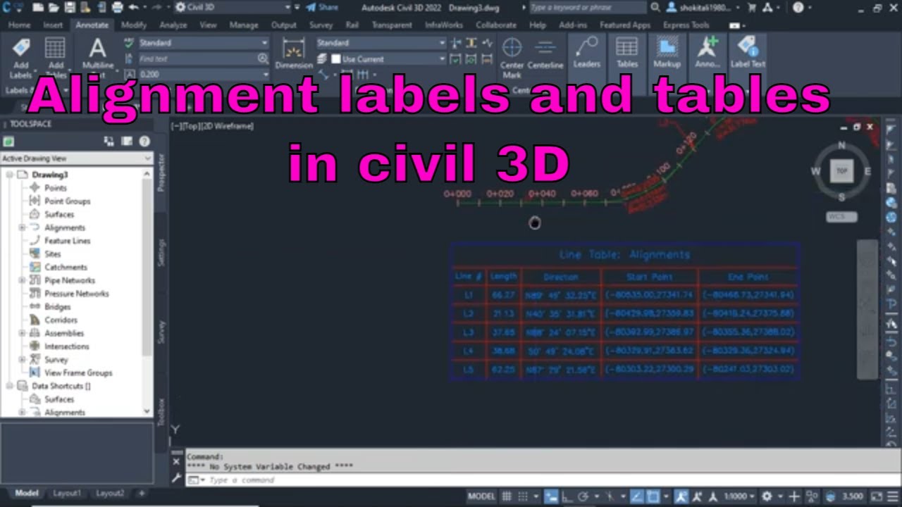
Display Labels on On-Road Alignment or any Alignment and Create an Alignment label table in Part 2
Автор: Murad Farooq
Загружено: 2021-08-20
Просмотров: 1092
Описание:
In This Video, I will explain how to Display Labels on On-Road Alignment or any Alignment and Create an Alignment labels table in Civil 3D. Part-2
#Alignment,#labels,#roaddesign
Part-1 Video
• Display Labels on On-Road Alignment or any...
Udemy Course link:-
https://www.udemy.com/course/road-des...
Complete Road design + open channel + Roundabout Design with very details Course on Udemy is live now and I am offering my youtube students with discount hurry up and enroll now for a limited time offer best of luck. I am offering a 50% discount for my youtube Students.
Related Videos:-
1)How to Change Background Color Settings in Civil 3d
• How to Change background Color Settings in...
2)How To Import Points In Civil 3D Ch# 01
• How To Import Points In Civil 3D. CH# 01
3)How to Create Surface with Contours and Basic Drawing settings Ch# 02
• How to Create Surface with Contours and Ba...
4)How To Draw Road Alignment In Civil 3D CH# 03
• How To Draw Road Alignment In Civil 3D. C...
5)How To Draw and Prepare Survey As built Data in Civil 3D and Export Data to Excel
• How To Draw and Prepare Survey As built Da...
6) How To Calculate Volume In Civil 3D. CH# 05
• How To Calculate Volume In Civil 3D. Autod...
7)How To Draw Simple Road Profile By Using Lisp. CH# 06
• How To Draw Simple Road Profile By Using L...
8)How To Prepare Leveling Control Report Road alignment,as-built, Export data to Excel. CH# 07
• How To Prepare Leveling Control Report Roa...
9) How To Import X,Y,Z Coordinates From Excel To Auto cad. CH# 08
• How To Import X,Y,Z Coordinates From Excel...
10) HOW TO DRAW COORDINATES ON ROAD ALIGNMENT / CENTERLINE. CH# 09
• HOW TO DRAW COORDINATES ON ROAD ALIGNMENT ...
11) 1)How to Change Background Color Settings in Civil 3d
• How to Change background Color Settings in...
2)How To Import Points In Civil 3D Ch# 01
• How To Import Points In Civil 3D. CH# 01
3)How to Create Surface with Contours and Basic Drawing settings Ch# 02
• How to Create Surface with Contours and Ba...
4)How To Draw Road Alignment In Civil 3D CH# 03
• How To Draw Road Alignment In Civil 3D. C...
5)How To Draw and Prepare Survey As built Data in Civil 3D and Export Data to Excel
• How To Draw and Prepare Survey As built Da...
6) How To Calculate Volume In Civil 3D. CH# 05
• How To Calculate Volume In Civil 3D. Autod...
7)How To Draw Simple Road Profile By Using Lisp. CH# 06
• How To Draw Simple Road Profile By Using L...
8)How To Prepare Leveling Control Report Road alignment,as-built, Export data to Excel. CH# 07
• How To Prepare Leveling Control Report Roa...
9) How To Import X,Y,Z Coordinates From Excel To Auto cad. CH# 08
• How To Import X,Y,Z Coordinates From Excel...
10) HOW TO DRAW COORDINATES ON ROAD ALIGNMENT / CENTERLINE . CH# 09
• HOW TO DRAW COORDINATES ON ROAD ALIGNMENT ...
11) Create Surface Profile and Profile Views. CH# 10
• Create Surface Profile and Profile Views. ...
12) How To Draw Road Widening In Civil 3D. CH#11
• How To Draw Road Widening In Civil 3D. CH#11
13) How To Do Link Excel Data To AutoCAD. CH# 12
• How To Do Link Excel Data To AutoCAD. CH# 13
14) How to Create Road Profile in AutoCAD Civil 3D Road Design Profile on Existing CH# 13
• How to Create Road Profile in AutoCAD Civi...
15) How to Create Surface Profile from File In AutoCAD Civil 3D. CH# 14
• How to Create Surface Profile from File In...
16) 5 Best Ways To Create Best Fit Alignment and Profile In Autocad Civil 3D. CH#15
• 5 Best Ways To Create Best Fit Alignment a...
17) How To Create Superimposed Profile|Road Alignment in Autocad Civil 3D. CH#16
• How To Create Superimposed Profile|Road Al...
18) How To Add and Edit New Profile Bands In AutoCAD Civil 3D. CH#17
• How To Add and Edit New Profile Bands In A...
19) Display Horizontal and Vertical Geometry Data in Profile Bands AutoCAD Civil 3D. Ch#18
• Display Horizontal and Vertical Geometry D...
20) How to Save and Import Profile Bands In AutoCAD Civil 3D. CH#19
• How to Save and Import Profile Bands In Au...
21) How to Create Road Assembly in AutoCAD Civil 3D . CH#20
• How to Create Road Assembly in AutoCAD Civ...
22) How to Create Corridor |Road| in AutoCAD Civil 3D. CH#21
• How to Create Corridor |Road| in AutoCAD C...
23) How To Create Corridor Surface and Sample Lines. CH#22
• How To Create Corridor Surface and Sample ...
24) How to Draw Road Cross Sections In AutoCAD Civil 3D. CH#23
• How to Draw Road Cross Sections In AutoCAD...
25) How To Calculate Road Cross Section Volume In AutoCAD Civil 3D. |Earth Work, Table and Report| CH#24
• How To Calculate Road Cross Section Volume...
26) How to Draw Existing Ground, Finish Ground and Cut Fill Surface Elevation In AutoCAD Civil 3D CH# 25
• How to Draw Existing Ground, Finish Ground...
27) How To Calculate Cut and Fill Surface Volume With Spot Elevation In AutoCAD Civil 3D. CH#26
• How To Calculate Cut and Fill Surface Volu...
Повторяем попытку...

Доступные форматы для скачивания:
Скачать видео
-
Информация по загрузке: