ycliper

Популярное

Музыка Кино и Анимация Автомобили Животные Спорт Путешествия Игры Юмор

Интересные видео

2025 Сериалы Трейлеры Новости Как сделать Видеоуроки Diy своими руками

Топ запросов

смотреть а4 schoolboy runaway турецкий сериал смотреть мультфильмы эдисон
Скачать

Tutorial - Qgis Orfeo ToolBox Classification Step 1/5: Compute raster statistics data

Автор: ONF International

Загружено: 2015-02-05

Просмотров: 12116

Описание: This video tutorial is inside a serie of 6 video which describe each step of the classification process given by Orfeo ToolBox in Qgis.

Step 0: Load data
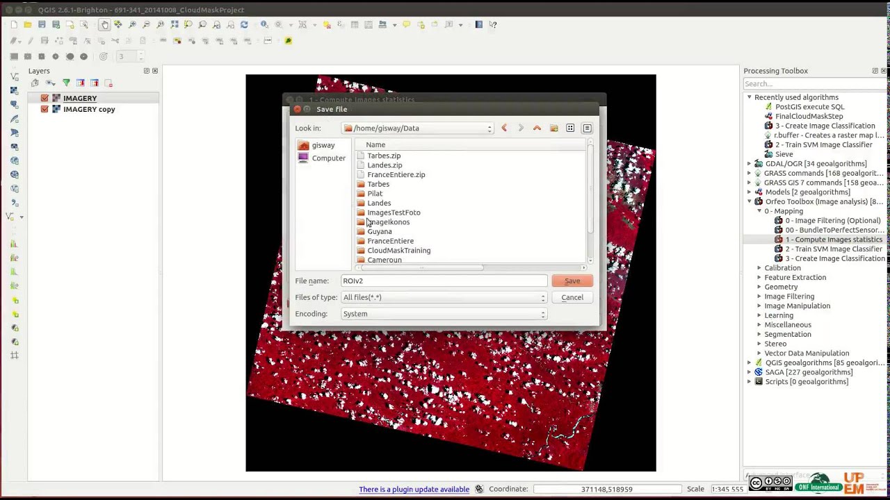
Step 1: Compute Raster Statistics
Step 2: Create ROI shape file
Step 3: Train SVM classifier to build training model
Step 4: Create Classification file
Step 5: Sieve filtering - Remove small pixel agregate

To use it you need
1- install Qgis with this tutorial    • Tutorial - Step 1/2 Qgis installation with...  
2- Customize OTB menu with this Tutorial    • Tutorial - Step 2/2 Orfeo ToolBox classifi...  

Step 1/5 explain how to make Raster Statistic file.

Previous Step: Load data    • Tutorial - Qgis Orfeo ToolBox Classificati...  
Next Step: Create Shape ROI    • Tutorial - Qgis Orfeo ToolBox Classificati...  

http://www.onfinternational.org/en/

Не удается загрузить Youtube-плеер. Проверьте блокировку Youtube в вашей сети.
Повторяем попытку...
Tutorial - Qgis Orfeo ToolBox Classification Step 1/5: Compute raster statistics data

Поделиться в:

Доступные форматы для скачивания:

Скачать видео

  • Информация по загрузке:

Скачать аудио

Похожие видео

Tutorial - Qgis Orfeo ToolBox Classification Step 2/5: how to create ROI shape file

Tutorial - Qgis Orfeo ToolBox Classification Step 2/5: how to create ROI shape file

OOC in QGIS with ORFEO, Part 1

OOC in QGIS with ORFEO, Part 1

Hania Rani live at Invalides in Paris, France for Cercle

Hania Rani live at Invalides in Paris, France for Cercle

POLAK DAŁ SYGNAŁ! BARCA GROMI RYWALA! BARCELONA - KOPENHAGA, SKRÓT MECZU

POLAK DAŁ SYGNAŁ! BARCA GROMI RYWALA! BARCELONA - KOPENHAGA, SKRÓT MECZU

LiDAR Point Cloud Vectorization: 3D Python Tutorial (+ LoD City Models)

LiDAR Point Cloud Vectorization: 3D Python Tutorial (+ LoD City Models)

Land Use Land Cover Classification in QGIS

Land Use Land Cover Classification in QGIS

Sade - Ultimate

Sade - Ultimate

Performing stand counts using multispectral data and index thresholding in QGIS

Performing stand counts using multispectral data and index thresholding in QGIS

Object-Based Classification Using OTB || Orfeo Toolbox QGIS

Object-Based Classification Using OTB || Orfeo Toolbox QGIS

How to Install Orfeo Toolbox in QGIS and Perform MeanShift Segmentation

How to Install Orfeo Toolbox in QGIS and Perform MeanShift Segmentation

Unsupervised Classification Using the SCP Plugin in QGIS 3.10 (Lab 5- V2)

Unsupervised Classification Using the SCP Plugin in QGIS 3.10 (Lab 5- V2)

Activar las herramientas de Orfeo Toolbox(OTB) EN QGIS  3.8

Activar las herramientas de Orfeo Toolbox(OTB) EN QGIS 3.8

GOL BRAMKARZA W DOLICZONYM CZASIE! SCENY ABSOLUTNE W LIZBONIE! BENFICA  - REAL MADRYT, SKRÓT MECZU

GOL BRAMKARZA W DOLICZONYM CZASIE! SCENY ABSOLUTNE W LIZBONIE! BENFICA - REAL MADRYT, SKRÓT MECZU

Smoke Mood — Just Relax | Deep House Mix 2026 • Chill / Night Vibes / Stress Relief  #3

Smoke Mood — Just Relax | Deep House Mix 2026 • Chill / Night Vibes / Stress Relief #3

2Hour UHD Relaxing Aesthetic Hydrochrome  Pastel Liquid  Gradient with   LED Mood Light

2Hour UHD Relaxing Aesthetic Hydrochrome Pastel Liquid Gradient with LED Mood Light

ГЛУБОКОЕ ОБУЧЕНИЕ в QGIS: сегментация изображений (аэрофотоснимков и спутниковых снимков) с помощ...

ГЛУБОКОЕ ОБУЧЕНИЕ в QGIS: сегментация изображений (аэрофотоснимков и спутниковых снимков) с помощ...

Abstract Black and White wave pattern| Height Map Footage| 3 hours Topographic 4k  Background

Abstract Black and White wave pattern| Height Map Footage| 3 hours Topographic 4k Background

Flying Through Clouds — 4K UHD Amazing Nature Screensaver (No Sound)

Flying Through Clouds — 4K UHD Amazing Nature Screensaver (No Sound)

Landsat 9 Image Classification with QGIS (Unsupervised)

Landsat 9 Image Classification with QGIS (Unsupervised)

Как создать почвенную карту в QGIS

Как создать почвенную карту в QGIS

© 2025 ycliper. Все права защищены.


  • Контакты
  • О нас
  • Политика конфиденциальности


Контакты для правообладателей: [email protected]