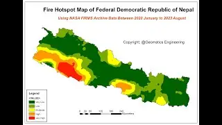
Forest Fire Hotspot Analysis with Data from NASA FIRMS (VIIRS 2024)
Автор: Geomatics Engineering Nepal (ROGE)
Загружено: 2024-05-03
Просмотров: 327
Описание:
"Welcome to Our Geomatics Engineering Nepal YouTube channel"
"Forest Fire Hotspot Analysis with Data from NASA FIRMS (VIIRS 2024)"
Harnessing the power of cutting-edge technology and satellite imagery, the Forest Fire Hotspot Analysis with Data from NASA FIRMS (VIIRS 2024) offers a comprehensive and dynamic tool for monitoring, analyzing, and responding to forest fires globally. Utilizing data from the Visible Infrared Imaging Radiometer Suite (VIIRS) onboard NASA's satellites, this analysis provides real-time and historical insights into the distribution, intensity, and progression of forest fires.
At its core, this analysis combines advanced algorithms with high-resolution satellite imagery to detect thermal anomalies indicative of active fires. By pinpointing these hotspots with remarkable accuracy, it enables timely and targeted intervention efforts to mitigate the impact of forest fires on ecosystems, communities, and infrastructure.
Key features of the Forest Fire Hotspot Analysis include:
1. **Real-time Monitoring**: Continuously updated data allows for the instant detection and tracking of forest fire hotspots, enabling rapid response and resource allocation.
2. **Historical Analysis**: Access to historical fire data facilitates trend analysis, pattern identification, and the assessment of fire behavior over time, empowering stakeholders with valuable insights for long-term planning and risk management.
3. **Geospatial Visualization**: Interactive maps and visualizations present forest fire hotspots in spatial context, enhancing situational awareness and facilitating informed decision-making by policymakers, emergency responders, and conservationists.
4. **Risk Assessment**: By integrating environmental variables such as temperature, humidity, and vegetation cover, this analysis supports comprehensive risk assessment models, enabling proactive measures to prevent and mitigate forest fire incidents.
5. **Customized Alerts**: Tailored alert systems notify users of new hotspot detections, significant changes in fire behavior, or the proximity of fires to designated areas of interest, ensuring timely intervention and response coordination.
6. **Collaborative Platform**: Designed for interdisciplinary collaboration, the analysis platform facilitates data sharing, knowledge exchange, and coordination among stakeholders, fostering a collective approach to forest fire management and response.
7. **Scalability and Accessibility**: Cloud-based architecture ensures scalability to handle large volumes of data and enables seamless access from any location with internet connectivity, promoting widespread adoption and utilization across diverse user groups.
The Forest Fire Hotspot Analysis with Data from NASA FIRMS (VIIRS 2024) represents a powerful fusion of satellite technology, data analytics, and environmental science, empowering stakeholders worldwide to monitor, analyze, and address the complex challenges posed by forest fires with unprecedented precision and effectiveness.
Повторяем попытку...

Доступные форматы для скачивания:
Скачать видео
-
Информация по загрузке: