4K Seoul Drive | Scenic Han River Route via North Riverside Expressway 서울 강변북로 드라이브 전구간 주행 영상
Автор: Driving Hamsters: 4K GPS Drive
Загружено: 2022-04-20
Просмотров: 3518
Описание:
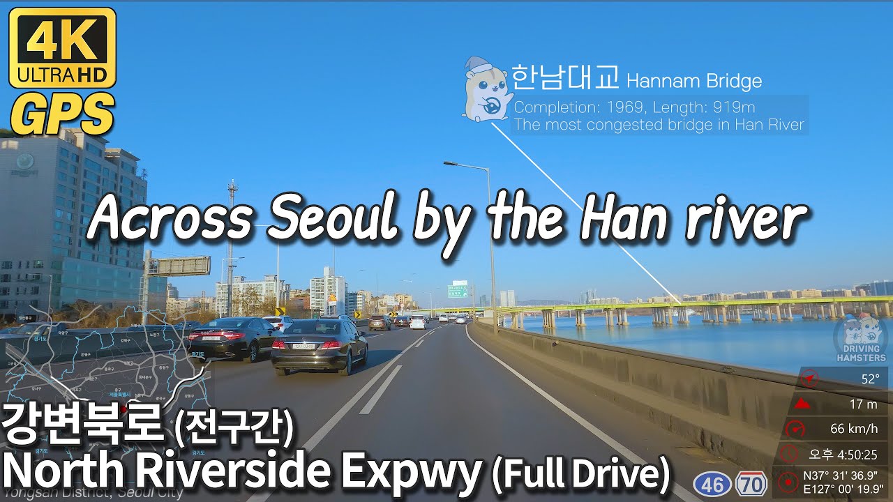
North riverside expressway(Korean: Gangbyeonbuk-ro) 4K Road trip video with GPS overlay and Landmark Tags!
North riverside expressway(Korean: 강변북로; Gangbyeonbuk-ro) is a expressway located in Seoul, South Korea. It opened in 1972. This route connects Seoul City to Namyangju City, with a total length of 37.37 km(23.22 mi). The highway is the main arterial road that connects northern Seoul City with satellite cities such as Goyang, Paju, and Namyangju City. Currently this road has the highest traffic volume in downtown Seoul. In 2012, road improvement projects were proposed including the underground relocation of the road construction by Seoul City. Along this road, you can find almost all Han River bridges such as Mapo and Olympic Bridge and beautiful riverside scenaries including Yeoui Island, Haneul(Sky) Park, Lotte World Tower. Find these landmarks in this video.
Chapters:
00:00 Highlight
00:21 Goyang City, Gyeonggi Province
00:38 Starting point of the North riverside expwy
00:57 Mapo District, Seoul City
11:47 Yeongdeungpo District, Seoul City
12:01 Yongsan District, Seoul City
22:43 Seongdong District, Seoul City
26:19 Gwangjin District, Seoul City
31:51 Guri City, Gyeonggi Province
37:08 Namyangju City, Gyeonggi Province
38:48 Endpoint of the North riverside expwy
Filmed: Late-January 2022.
Temp.: 4℃(39℉)
Повторяем попытку...
Доступные форматы для скачивания:
Скачать видео
-
Информация по загрузке:


![[4k]지금에 머무는 시간.Ep. 148_100분 풀버전 _ASMR](https://imager.clipsaver.ru/X6YGSI80qVY/max.jpg)

![[4K] Relaxing Evening Drive | Lexus Hybrid Spatial Audio | Crossing Huangjuewan Interchange治愈系静谧盘龙立交](https://imager.clipsaver.ru/0PpGqKipF_E/max.jpg)


![[4K] Driving Downtown Seoul Gangnam, Teheran, Cheongdam POV](https://imager.clipsaver.ru/WVb-cQUID2A/max.jpg)

