Скачать
RF planning with Google Earth - 2011
Автор: cloudrfdotcom
Загружено: 2023-06-16
Просмотров: 1951
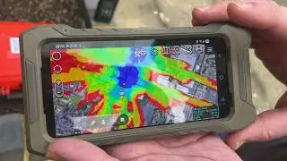
Описание: Historic demonstration of the Google Earth interface at cloudrf.com. This interactive overlay allows registered users to perform VHF/UHF RF coverage predictions with several clicks. The crosshairs in the centre of the screen are used for siting the antenna, a pop-up form allows RF parameters to be entered. Clicking calculate sends the data to cloudrf.com for processing. The entire process takes several seconds and is powered by SPLAT!
Не удается загрузить Youtube-плеер. Проверьте блокировку Youtube в вашей сети.
Повторяем попытку...
Повторяем попытку...

Доступные форматы для скачивания:
Скачать видео
-
Информация по загрузке: