ycliper

Популярное

Музыка Кино и Анимация Автомобили Животные Спорт Путешествия Игры Юмор

Интересные видео

2025 Сериалы Трейлеры Новости Как сделать Видеоуроки Diy своими руками

Топ запросов

смотреть а4 schoolboy runaway турецкий сериал смотреть мультфильмы эдисон
Скачать

Prediction of Land Use/Land Cover Change using QGIS and ArcGIS (2010-2020-2030)

GIS

Remote sensing

arcgis

gisrs

learn arcgis

how to create map in arcgis

arcgis bangladesh

GIS youtube channel

Geography

spatial science

geospatial science

lulc prediction

how to predict land use and land cover

MOLUSCE plugin

Land use and land cover change prediction using QGIS

LULC prediction using GIS

how to simulation LULC

Land use and land cover map prediction

LULC Prediction

LULC time series prediction

Автор: GIS & RS Solution

Загружено: 2020-11-15

Просмотров: 170683

Описание: 
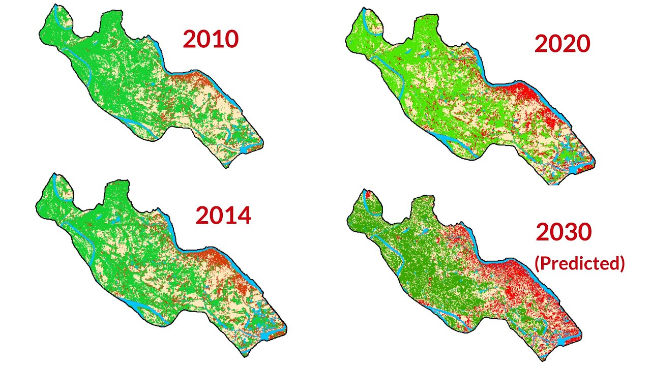
Today I’ll show you how to prepare Land use and land cover prediction map using MOLUSCE Plugin of QGIS (Modules for Land Use Change Evaluation).

In this tutorial I will do prediction map for the year of 2030.
For doing this, along with LULC map, you need to create some variable maps like DEM, Distance from Road, Distance from River, Slope, distance from settlement etc. that can be influenced to change the future land use and land cover. Here I am using Distance from road and DEM as variables.
Remember that, All Maps need to be prepared and saved in same spatial resolution and geographical references.

I have prepared a manual for Land use change prediction. IF YOU Need then, write your email in the comment section of this video. I’ll send you then. If you like this video, then you can consider SUBSCRIBING this channel to get cool GIS.

Watch my video along with the instruction and then try to make your LULC prediction map. If you don’t know how to prepare LULC map, check my videos. Also, if you don’t have country shapefile, road shapefile etc. just check my videos how to download shapefiles for any country.

LULC by Supervised classification:   • Supervised Image Classification | Land Use...  
LULC by Unsupervised Classification:    • Unsupervised Classification | Land Cover M...  
Accuracy Assessment:    • Accuracy Assessment | Kappa Coefficient | ...  
GIS Shapefile for any country:    • GIS Shapefile of any Country  

Related Tags: lulc prediction, how to predict land use and land cover, MOLUSCE plugin, Land use and land cover change prediction using QGIS, LULC prediction using GIS, how to simulation LULC, Land use and land cover map prediction, LULC Prediction, LULC time series prediction

#LULC_prediction #ArcGIS_Tutorial #GIS_RS_SOLUTION

Не удается загрузить Youtube-плеер. Проверьте блокировку Youtube в вашей сети.
Повторяем попытку...
Prediction of Land Use/Land Cover Change using QGIS and ArcGIS (2010-2020-2030)

Поделиться в:

Доступные форматы для скачивания:

Скачать видео

  • Информация по загрузке:

Скачать аудио

Похожие видео

How to Increase Image Resolution in ArcGIS

How to Increase Image Resolution in ArcGIS

Predict Future Land Cover in Google Earth Engine

Predict Future Land Cover in Google Earth Engine

MOLUSCE 4 — LULC change detection and prediction with free QGIS tool. Land Use Change Simulations

MOLUSCE 4 — LULC change detection and prediction with free QGIS tool. Land Use Change Simulations

LULC change detection using ArcGIS | 2001 & 2021

LULC change detection using ArcGIS | 2001 & 2021

Prediction of Land Use/Land Cover Change using QGIS and ArcGIS (2010-2020-2030)

Prediction of Land Use/Land Cover Change using QGIS and ArcGIS (2010-2020-2030)

Азербайджан и Россия — дальше будет хуже | Рейды в Екатеринбурге, задержания в Баку

Азербайджан и Россия — дальше будет хуже | Рейды в Екатеринбурге, задержания в Баку

Prediction Of Land Use / Land Cover Change Using QGIS and ArcGIS (2010- 2020- 2030)

Prediction Of Land Use / Land Cover Change Using QGIS and ArcGIS (2010- 2020- 2030)

Итоги дня | Обыски у главы МВД | Взрыв в центре Москвы | Кремль про конфликт с Баку

Итоги дня | Обыски у главы МВД | Взрыв в центре Москвы | Кремль про конфликт с Баку

Трамп объявил о прекращении огня / Конец российского наступления?

Трамп объявил о прекращении огня / Конец российского наступления?

PREDICT FUTURE LAND COVER CHANGE IN QGIS || MOLUSE PLUGIN

PREDICT FUTURE LAND COVER CHANGE IN QGIS || MOLUSE PLUGIN

© 2025 ycliper. Все права защищены.


  • Контакты
  • О нас
  • Политика конфиденциальности


Контакты для правообладателей: [email protected]