MR GIS Official
Hello! I am Sajjad Gondal, I have experience in troubleshooting and configuring wordpress, i can install, customize, migrate, Edit or update Your Wordpress websites. I'm also a GIS Analyst and cartographer having experience in ArcGIS, QGIS, ERDAS for Remote sensing, PostgreSQL, POstGIS, and other spatial software's. Have done so many GIS related projects and searching online work for Data analysis, Visualization,GIS Modelling, Web Mapping or any GIS task. MESSAGE ME ANYTIME!!

University of Gujrat Admissions update 2025 / #geography #remotesensing #gis

How to Change Map Projection Coordinate System of a Raster in ArcGIS in Hindi

How To Create Point Density Map using ArcGIS | Urdu|Hindi

How to Add Horizontal Legend in ArcMap in Urdu/Hindi

How to Download Landsat 9 Imagery for free in Urdu/Hindi

How to convert KMZ to shapefile (layer) in ArcGIS in urdu/hindi

How to create random points using ArcGIS in Urdu/Hindi

How to Increase Image Resolution in ArcGIS in Urdu & Hindi

How to clip any district from country shapefile in ArcGIS in Urdu & Hindi || Part 3 ||

How to clip any district from country shapefile in ArcGIS in Urdu & Hindi || Part 2 ||

Online clearance system in Uog

How to clip any district from country shapefile in ArcGIS in Urdu & Hindi || Part 1 ||

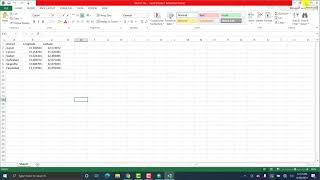
How to drag in excel || Excel fill series in Urdu/Hindi
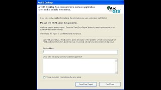
ArcGIS Desktop has encountered a serious application error and is unable to continue in Urdu/Hindi

How excel function and formulas works for beginners | level II

Basic parts of Microsoft Excel for beginner's | Level 1

How to calculate NDBI using ArcGIS in Urdu/Hindi || Lecture Number 40

How to add XY coordinate value in ArcGIS in Urdu/Hindi || Lecture Number 39

How to convert Table to Excel file in ArcGIS in Urdu/Hindi || Lecture Number 38

Amazon Rainforest Facts
How to convert Excel file to Table in ArcGIS in Urdu/Hindi || Lecture Number 37

Kernel Density in ArcGIS in Urdu/Hindi || Lecture Number 36

Point Density in ArcGIS in Urdu/Hindi || Lecture Number 35

Environmental pollution its types causes effects || Part 1

How to calculate NDSI using ArcGis in urdu/hindi || Lecture Number 34

How to calculate NDWI using ArcGis in urdu/hindi || Lecture Number 33

How to create choropleth (thematic) map in ArcGIS in urdu/hindi || Lecture Number 32

How to create point line polygon KML/KMZ Files in Google Earth in English

How to Convert layers to kml/kmz (Google Earth) | By Mr. GIS

How to Convert layers to kml/kmz (Google Earth) in ArcGIS in Urdu/Hindi || Lecture Number 31