gNext

Substation short

gNext - ESRI Integration: ArcGIS Online Example

Highway Bridge Management and Inspection: Digital Twin + A.I.

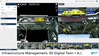
Telecom Infrastructure Management: 3D Digital Twin + AI

Slope Stability Inspection

Power Grid Infrastructure Management: 3D Digital Twin - Skydio X10

Airport Runway Inspection and Management: Digital Twin + AI

Nighttime and Low-Light Tunnel Infrastructure Inspection - Skydio X10 L Model

Highwall Inspection

Runway Approach Clearance: Managing Vegetation for Optimal Safety - WingtraOne Drone Sony RX1R II

High Mast Light Pole Inspection via Drone - Data Collected by CONSOR Engineers with Skydio 2+
Infrastructure Management and Inspection - Skydio 2 Data

3D Digital Infrastructure Inspection - Phase One iXM-100 Camera

3D Digital Model + AI for Bridge Inspection

Overlay Visualizations + Drone and Mobile Surveys

Document Management System + Drone and Mobile Surveys

Power Grid Infrastructure Management: GIS + 3D Digital Twin + AI.

Accident Reconstruction: 3D Digital Twin. Data Collected with Skydio Drone

Efficiently document evidence of damage and quantify loss and risk exposure using Drones

Digital Twin + AI for Cell tower Management and Inspection Using Drones (Lattice Cell Tower)

Digital Twin + AI for Cell tower Management and Inspection Using Drones (Monopole Cell Tower)

quarry stockpile volumetric measurement

High Resolution Digital Twin - Quarry - Phase One iXM-100 (100 Megapixels) Camera - Drones

Dam Inspection & Management: 3D Digital Twins + AI (Drones)

Property Inspection & Facility Management: Digital Twin + AI (DJI Drone)

Image Navigation Tools for Bridge Inspections Using 3D Digital Twins (Skydio 2 with Skydio 3D Scan).

Property Inspection & Facility Management: Digital Twin + AI (DJI Drone)

gNext. Empowering Infrastructure Management

3D Digital Model + AI for Bridge Inspection and Management.

Rail Infrastructure Management: 3D Digital Model + AI