CAD SURVEY
My videos depends upon learning all about professional LAND SURVEYORS
contactact info:-
[email protected]

Convert millimeter drawing to meter in autocad

Basic assembly and subassembly in civil3d #42

Display distance and azimuth of polyline in autocad

Elevation marker autolsp

Superelevation labels of alignment civil3d #41

Superelevation band style in civil3d #40

Superelevation level calculation by excel sheet

Superelevation grade calculation by excel sheet

Superelevation of alignment civil3d #39

Profile labels in civil3d (L-38)

How to import and export band set in civil3d

How to add horizontal and vertical alignment data in profile band style civil3d (L-37)

Design profile geometry editor in civil3d (L-36)

Draw design profile and cut fill band style in civil3d (L-35)

Create new profile band style civil3d station and elevation (L-34)

Split profile automatic and manual in autocad civil3d (L-33)

Profile view style in autocad civil3d (L-32)

Create surface profile in civil3d (L-31)

Alignment report coordinates and elevation from surface in civil3d (L-30)

Alignment label in civil3d (L-29)

Properties and alignment style civil3d (L-28)

How to rotate cross hair in autocad with command

Draw alignment by multiple method in civil3d (L-27)

Why not select multiple object in autocad what is solution

Add spiral to alignment of civil3d (L-26)

Best app for Quantity calculation,concrete,bricks,plaster,steel

Floating line and curve with spiral to an alignment of civil3d (L-25)
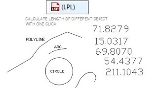
Total length of multiple object in autocad

Floating lines and curves to an alignment of civil3d (L-24)

Fixed line and fixed curve to an alignment of civil3d (L-23)