OpenGeoHub Foundation Official Channel
OpenGeoHub is a not-for-profit research foundation with headquarters in Wageningen, the Netherlands (Stichting OpenGeoHub, KvK 71844570). The main goal of the OpenGeoHub is to promote publishing and sharing of Open Geographical and Geoscientific Data and using and developing of Open Source Software. We believe that the key measure of quality of research in all sciences (and especially in geographical information sciences) is in transparency and reproducibility of the computer code used to generate results.

Nils Broothaerts and The EU Soil Observatory

Luis de Sousa: GRASS GIS automation for Earth Observation with Python, R and Julia

Yu Feng Ho: Introduction of cloud native vector format hands on in Python environment

Edzer Pebesma: Cloud based analysis of Earth Observation data using open source software

Tom Hengl: Spatiotemporal ML 15 practical lessons on how to organize monitoring modelling

Wouter van der Wal: Introduction to the EO Council

Edzer Pebesma: Raster and vector data cubes in R and Python

Nico Lang: Learning From Global Earth Observation Data

Leandro Parente: Monitoring global grassland and pasture areas An integrated approach

NSO Companies Fair Networking borrel

Sander Houweling: Data use in remote sensing of the atmosphere

Deborah C. Stein Zweers: What does high resolution mean? Space-based spectrometry for air quality

Ralf Kohlhaas: Passive optical instruments for Earth Observation

Haili Hu: Introduction to SURF

Serkan Girgin: Monitoring EO workflows with precision for better performance & resource utilization

Maarten Pronk: An introduction to Julia

Pratichhya Sharma: Advanced EO Workflows with Custom Functions in openEO within CDSE

Steffen Fritz: Preventing Catastrophic Climate Change: The Role of In-Situ & citizen science data

Tom Hengl & Alexandre Wadoux: terra package / generating sampling designs using R

Luis de Sousa: Introduction to GRASS GIS as a spatial analysis engine

Pratichhya Sharma: Introduction to openEO within the Copernicus Data Space Ecosystem
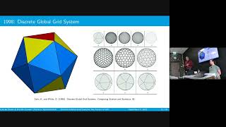
Luis de Sousa: Discrete Global Grid Systems Awareness raising about the future of GIS

Yu-Feng Ho: Geomorphometry high performance computing using GRASS GIS, and WhiteboxTools in Python
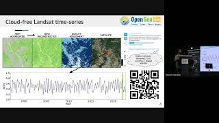
Davide Consoli: Space time mapping at 30 m resolution based on Landsat ARCO data

Pontus Lurcock: Application Packages in the xcube ecosystem

Marc Middendorp: Introduction to NSO

Jeroen Rietjens: Processing PACE data with Python get a polarized hyperspectral view of the Earth

Ad Stoffelen: Observing earth system dynamics on weather and climate scales

Nico Lang: Learning Representations From Engineering Features to Engineering Pretext Tasks

Jochen Landgraf: Greenhouse Gas Remote Sensing using Absorption Spectroscopy Hands on experience